Uttarakhand
Officials Asked to Shift Government Buildings From Red Zone in Joshimath
- 21 Mar 2024
- 4 min read
Why in News?
Recently, Chamoli District Magistrate (DM) asked officials to conduct a survey of government buildings and properties in the unsafe red zone in land-subsidence hit Joshimath and shift them to safe locations.
Key Points
- The DM also asked officials to offer all rehabilitation options to the subsidence-affected families falling under the red zone in Joshimath.
- Joshimath Bachao Sangharsh Samiti and Joshimath Mool Niwasi Swabhiman Sangathan have opposed the state government's rehabilitation policy and put forth 15 demands, including initiating remedial measures for the land-subsidence problem in Joshimath, and a displacement allowance for the affected people.
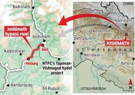
Joshimath
- Joshimath is a hilly town located on the Rishikesh-Badrinath National Highway (NH-7) in Chamoli district of Uttarakhand.
- The city serves as a tourist town as it acts as an overnight rest stop for people visiting Badrinath, Auli, Valley of Flowers, and Hemkund Sahib, among other important religious and tourist locations in the state.
- Joshimath is also of great strategic importance to the Indian armed forces and is home to one of the Army's most important cantonments.
- The town (fall in high-risk seismic Zone-V) is traversed by running streams with a high gradient from Vishnuprayag, a confluence of the Dhauliganga and the Alaknanda rivers.
- It is home to one of the four cardinal maths or monasteries established by Adi Shankara - Sringeri in Karnataka, Dwarka in Gujarat, Puri in Odisha and Joshimath near Badrinath in Uttarakhand.
Joshimath Sinking
- Background:
- Cracks on walls and buildings were first reported in 2021, as Chamoli district of Uttarakhand experienced frequent landslides and flooding.
- As per reports, the Uttarakhand government's expert panel in 2022 found that several pockets of Joshimath are "sinking" owing to man-made and natural factors.
- It was found that a gradual settling or sudden sinking of the earth's surface due to the removal or displacement of subsurface materials — has induced structural defects and damage in almost all wards of the city.
- Reasons:
- Site of an Ancient landslide: According to the 1976 Mishra Committee report, Joshimath lies on a deposit of sand and stone,not on the main rock. It lies on an ancient landslide. The report added that undercutting by river currents of Alaknanda and Dhauliganga are also playing their part in bringing landslides.
- The committee had recommended that restrictions be placed on heavy construction work, blasting or digging to remove boulders for road repairs and other construction, felling of trees.
- Geography: Scattered rocks in the area are covered with old landslide debris comprising boulders, gneissic rocks, and loose soil, with a low bearing capacity.
- These gneissic rocks are highly weathered and have a low cohesive value with a tendency of high pore pressure when saturated with water, especially during monsoons.
- Construction Activities: Increased construction, hydroelectric projects, and the widening of the NH have made the slopes highly unstable in the last couple of decades.
- Land Erosion: Due to the running streams from Vishnuprayag and sliding along the natural streams are the other reasons behind the city's fate.
- Site of an Ancient landslide: According to the 1976 Mishra Committee report, Joshimath lies on a deposit of sand and stone,not on the main rock. It lies on an ancient landslide. The report added that undercutting by river currents of Alaknanda and Dhauliganga are also playing their part in bringing landslides.
- Impact:
- At least 66 families have fled the town while 561 houses have reported cracks. A government official said that over 3000 people have been affected so far.


