-
20 Jan 2023
GS Paper 1
Geography
Day 63
Question 1. Discuss the direct and indirect sources to study interior of earth. (150 words)
Question 2. What do you understand by volcanos. Discuss the intrusive and extrusive volcanic landform. (250 words)Answer 1
Approach
- Start your answer by explaining different layers of interior of the earth.
- Discuss the direct and indirect sources to study interior of earth.
- Conclude suitably.
Introduction
- A large number of hypotheses were put forward regarding the origin of the earth like Laplace’s theory of Nebular Hypothesis and Otto Schmidt and Carl Weizascar’s nebular hypotheses.
- The earth is made up of three different layers: the crust, the mantle and the core. There is very little information is available about the interior structure and composition of the earth because the interior of the earth can be understood only by direct and indirect evidence as neither anyone has nor anyone can reach the interior of the earth.
Body
Direct Sources of Earth’s interior:
- Mining: The most easily available solid earth material is surface rock or the rocks we get from mining areas. Gold mines in South Africa are as deep as 3 - 4 km.
- Drilling: Number of projects have been taken to penetrate deeper depths to explore the conditions in the crustal portions such as “Deep Ocean Drilling Project” and “Integrated Ocean Drilling Project”.
- The deepest drill at Kola, in Arctic Ocean, has so far reached a depth of 12 km. This deep drilling projects have provided large volume of information through the analysis of materials collected at different depths.
- Volcanic eruption: When the molten material (magma) is thrown onto the surface of the earth, during volcanic eruption it becomes available for laboratory analysis. However, it is difficult to ascertain the depth of the source of such magma.
Indirect Sources of Earth’s interior:
- Variations in physical properties: The temperature and pressure increase with the increasing distance from the surface towards the interior in deeper depths. And the density of the material also increases with depth of materials. And variation in these properties indicates the change in properties of material as well.
- Meteors: Meteors that reach the earth provide material for analysis. The material and the structure observed in the meteors are similar to that of the earth, though it is not from the interior of the earth.
- They are solid bodies developed out of materials same as, or similar to, our planet. Hence, this becomes yet another source of information about the interior of the earth.
- Analysis of several forces and waves: The gravitation, magnetic field, and seismic activity.
- Seismic activity: It is one of the most important sources of information about the interior of the earth. The study of seismic waves provides a complete picture of the layered interior.
- A zone between 105° and 145° from epicentre was identified as the shadow zone for both Primary & Secondary (P&S) waves. The entire zone beyond 105° does not receive S-waves. The shadow zone is a depiction of material inside earth with different densities.
- Gravity Anomaly: The gravitation force (g) is not the same at different latitudes on the surface. The gravity values differ according to the mass of material, poles and the equator.
- Gravity anomalies give us information about the uneven distribution of mass of the material in the crust of the earth and within the earth.
- Magnetic surveys: It also provide information about the distribution of magnetic materials in the crustal portion, and thus, provide information about the distribution of materials in this part.
- Seismic activity: It is one of the most important sources of information about the interior of the earth. The study of seismic waves provides a complete picture of the layered interior.
Conclusion
Volcanic eruption, gravity anomaly, and magnetic screening of other celestial planets like Mars and Venus can bring a clearer picture of the earth’s interior and accelerate geo-physical and geological research and development.
Answer 2
Approach
- Start the answer with what do you understand by Volcanoes.
- Discuss the intrusive and extrusive volcanic landform.
- Conclude suitably.
Introduction
A volcano is a vent (opening) in the earth’s crust through which molten material erupts suddenly from a magma chamber below the surface. Due to very high temperature, some rocks slowly melt and turn into a thick flowing matter known as magma. Since it is lighter than the solid rock around it, the magma rises and gets collected in magma chambers which eventually pushes through fissures and vents in the earth’s surface.
They are generally found where tectonic plates (like Eurasian, Pacific, Somali, etc.) diverge or converge. Examples- volcanoes occurring in mid-oceanic ridge and Ring of Fire.
Body
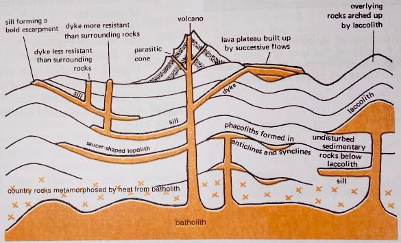
- The lava that is released during volcanic eruptions on cooling develops into igneous rocks. The cooling may take place either on reaching the surface or in the crustal portion.
- Igneous rocks are classified as volcanic rocks (cooling at the surface) and plutonic rocks (cooling in the crust). The lava that cools within the crustal portions assumes different forms. These forms are called intrusive landforms. The commonest intrusive landforms are-
- Sills: When an intrusion of molten magma is made horizontally along the bedding plains of sedimentary rocks, the resultant intrusions is called a sill.
- Dykes: Intrusions when injected vertically as narrow walls igneous rocks within the sedimentary layers are termed as dykes.
- Laccolith: It is large blister of igneous mound with a dome-shaped upper surface and a level base fed by a pip-like conduit from below.
- Lopolith: A lopolith is another variety of igneous intrusions with a saucer shape.
- Phacolith: It is a lenses-shaped mass of igneous rocks occupying the crest of an anticline or the bottom of a syncline and being fed by a conduit from beneath.
- Batholith: It is a huge mass of igneous rocks, usually granite, which after removal of the overlying rocks forms a massive and resistant upland region.
Extrusive Landforms:
- Cinder cones: Cinder cones are of low height and are formed of volcanic dust and ashes etc pyroclastic material. Falling under the influence of gravity, these particles accumulate around the vent, in a large pile.
- The form of a cinder cone is very distinctive, with steep straight sides and a crater (depression) at the top of the hill. E.g.: Volcano Parícutin, Mexico.
- Composite cones: A composite cone results when formative eruptions are sometimes effusive and sometimes explosive. Composite cones are therefore composed of a combination of lava flow and pyroclastic materials.
- They are also called stratovolcanoes because they are constructed of layers (strata) of pyroclastics and lava. They are formed due to deposition of alternate layers lava and fragmental material wherein lava acts as cementing material. E.g.: Mount Fuji in Japan.
- Shield volcanoes: When numerous successive basaltic lava flow occur in a given region, they can eventually pile up into the shape of a large mountain called a shield volcano. E.g.: Mauna Loa, Hawaii.
- Calderas: A caldera is a large, basin-shaped depression formed at the volcanic mouth. It forms when summit material on a volcanic mountain collapse inward after an eruption or other loss of magma. For example, Crater Lake, USA.
Conclusion
The seismic activities create the relief features of the first order like continents and ocean basins, which are fundamental relief features of the globe and develop other type of landforms which help in creation and sustenance of life on the earth.


