Science & Technology
China Launches BeiDou Navigation Satellite System
- 01 Aug 2020
- 6 min read
Why in News
China has formally launched full global services of its BeiDou-3 Navigation Satellite System (BDS).
Key Points
- Background:
- The name BeiDou comes from Chinese word for the Big Dipper or Plough constellation.
- China's BeiDou navigation project was launched in the early 1990s. The system then became operational within China in 2000 and in the Asia-Pacific region in 2012.
- The navigation satellite system was completed in three steps: BDS-1 which provided services to China, BDS- 2 to provide services to the Asia-Pacific region and BDS-3 which provides services worldwide.
- Features:
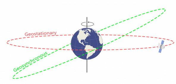
- A hybrid constellation consisting of around 30 satellites in three kinds of orbits: Geostationary Earth Orbit (GEO), Inclined Geo-Synchronous Orbit (IGSO) and Medium Earth Orbit (MEO).
- Provides navigation signals of multiple frequencies, and is able to improve service accuracy by using combined multi-frequency signals.
- Offers accurate positioning, navigation and timing, as well as short messaging communication, international search and rescue, satellite-based augmentation, ground augmentation and precise point positioning, etc.
- The services are used in various fields by China including defence, transportation, agriculture, fishing, and disaster relief.
- It will be the fourth global satellite navigation system after the USA GPS, Russia’s GLONASS and European Union’s Galileo.
- It is said to be much more accurate than the USA’s GPS.
- Global Navigation Satellite System (GNSS) is a general term describing any satellite constellation that provides Positioning, Navigation, and Timing (PNT) services on a global basis.
Implications
- Challenge to the Centrality of the USA: While China says it seeks cooperation with other satellite navigation systems, Beidou is being seen as a rival to America’s GPS, Russia’s GLONASS and the European Union’s Galileo networks.
- Military Implications: The development of its own secure and independent navigation system will boost China’s military strength, especially amidst rising US-China tensions.
- Economic Implications: The better accuracy and experience of BDS, as claimed by China will lure companies to sign-up for it. As the global market is being increasingly dominated by an information-based economy, China is expected to reap huge economic benefit from BDS.
- China’s Hold on Other Nations: China is promoting its use in the countries signed-up for its Belt and Road Initiative (BRI). Pakistan has already started using BDS. This will certainly give China economic and political leverage over nations adopting this system.
- Edge over India: This has also given China a competitive edge over India, whose IRNSS-NavIC is still a regional navigation system.
- Importance in Covid Times: The world is becoming heavily dependent on space infrastructure due to the impact of COVID-19 limitations on in-person physical meetings and travel restrictions. Thus, information and space-based services will gain importance in present times.
- China’s Authority in Space: The space program of China has seen rapid advancements in past few years with the launch of Tianwen-1 rover mission to Mars. China has also constructed an experimental space station and sent a pair of rovers to the surface of the moon (Chang’e-4). BDS is another step in marking China’s presence in Space.
IRNSS ― NavIC (India)
- The Indian Regional Navigation Satellite System (IRNSS), which was later given the operational name of NavIC or NAVigation with Indian Constellation, is the regional satellite navigation system of India.
- Launched and operated by the Indian Space Research Organisation (ISRO), IRNSS covers India and nearby regions extending up to 1,500 km.
- The constellation consists of 7 active satellites, out of which three are located in Geostationary Earth Orbit (GEO) and four in Inclined Geo-Synchronous Orbit (IGSO).
Satellite Orbits
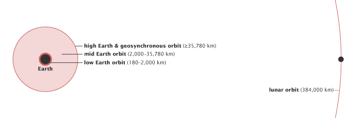
- An orbit is a regular, repeating path that an object in space takes around another one. An object moving around a planet in an orbit is called a satellite. According to the height of satellites from the earth, the orbits can be classified as
- High Earth orbit (mostly weather and communication satellites),
- Medium Earth orbit (most navigation satellites) and
- Low Earth orbit (Scientific satellites like NASA’s Earth observing Fleet).
- Geo-Synchronous orbit : A geosynchronous orbit is any orbit which has a period equal to the earth's rotational period.
- Geostationary Orbit: A Geostationary Orbit is a time of Geosynchronous orbit in the same plane as that of the equator.