Geographical Information System (GIS) | 01 May 2025
For Prelims: Geographical Information System, Spatial Data, Vector Data, Raster Data, Urban Planning, Environmental Management, Disaster Management, Agriculture, Space Research, Bhuvan, Bharat Maps, Gram Manchitra, Artificial Intelligence, IoT, Big Data, Cloud Computing, Open-Source GIS, SVAMITVA Scheme, National Geospatial Policy (NGP) 2022
For Mains: Geographical Information System (GIS): its significance in various sectors, related challenges and way forward.
What is a Geographical Information System (GIS)?
- About:
- A Geographical Information System (GIS) is a computer-based tool that allows users to capture, store, manipulate, analyze, manage, and visualize geographic or spatial data.
- It integrates hardware, software, and data for processing geographically referenced information.
- Types of GIS Data:
- Vector Data: One of the two primary data models used in GIS. It represents geographic features using points, lines, and polygons.
- Raster data: It represents the Earth's surface as a grid of cells or pixels, with each cell holding a value that represents a specific attribute, such as temperature, elevation, or land cover.
What are the Applications of GIS?
- Urban Planning:
- GIS is extensively used in urban planning to facilitate efficient and sustainable development. It helps in land-use mapping by identifying and categorizing areas into residential, commercial, industrial, and recreational zones.
- It supports infrastructure development by analyzing demographic trends, terrain, and existing utilities, thereby enabling the optimal placement of roads, public transportation, sewage systems, and other urban facilities.
- Environmental Management:
- GIS plays a vital role in conserving natural resources and environmental management.
- It is used to monitor deforestation by detecting changes in forest cover over time using satellite imagery.
- GIS also assists in tracking pollution, such as identifying the sources and spread of air, water, and soil pollutants.
- Furthermore, it supports the management of wildlife habitats by mapping migration routes, human encroachment, and biodiversity patterns.
- Disaster Management:
- GIS is a crucial tool in all phases of disaster management, i.e., prevention, preparedness, response, and recovery.
- It is employed in flood mapping to identify flood-prone areas by analyzing elevation and hydrological data.
- For earthquake risk assessment, GIS maps fault lines and identifies vulnerable structures and populations.
- During disasters, GIS supports relief and response operations by planning evacuation routes, locating shelters, and coordinating rescue efforts.
- Agriculture:
- In the field of agriculture, GIS enhances productivity and sustainability through data-driven decision-making.
- It enables precision farming by providing insights into crop health, soil conditions, and irrigation requirements.
- Soil analysis using GIS helps farmers determine soil fertility, pH levels, and moisture content.
- GIS is used for monitoring pest outbreaks, allowing for timely and targeted pesticide applications.
- Space Research:
- GIS is integral to space research, particularly in the planning and execution of space missions.
- It aids in planetary mapping by generating detailed maps of celestial bodies like the Moon and Mars, which are essential for scientific analysis and navigation.
- GIS also contributes to mission planning by helping researchers select safe and scientifically valuable landing sites.
- Moreover, when combined with remote sensing, GIS enhances the study of both Earth and extraterrestrial terrains.
How Does GIS Integrate with Other Technologies?
- AI and Machine Learning: GIS integrates with Artificial Intelligence (AI) and Machine Learning (ML) to enhance predictive modeling and spatial analysis.
- Predictive Modeling: AI can predict future trends, such as changes in land use, climate patterns, or urban growth, based on historical geospatial data.
- Image Classification and Object Detection: ML algorithms can classify land features, detect changes in satellite imagery, and automatically extract useful data from complex maps.
- Real-time Data Collection: The integration of the Internet of Things (IoT) with GIS allows for real-time data collection and monitoring of spatial phenomena.
- IoT devices, such as sensors and GPS trackers, generate continuous streams of geospatial data, which can be immediately analyzed and visualized on GIS platforms such as environmental monitoring, smart cities and disaster management.
- Big Data: Handling Large Geospatial Datasets: With the growth of large-scale geospatial data, Big Data technologies help handle and process massive datasets that traditional GIS tools may struggle with.
- GIS works with Big Data platforms to manage, analyze, and extract insights from vast amounts of geospatial information.
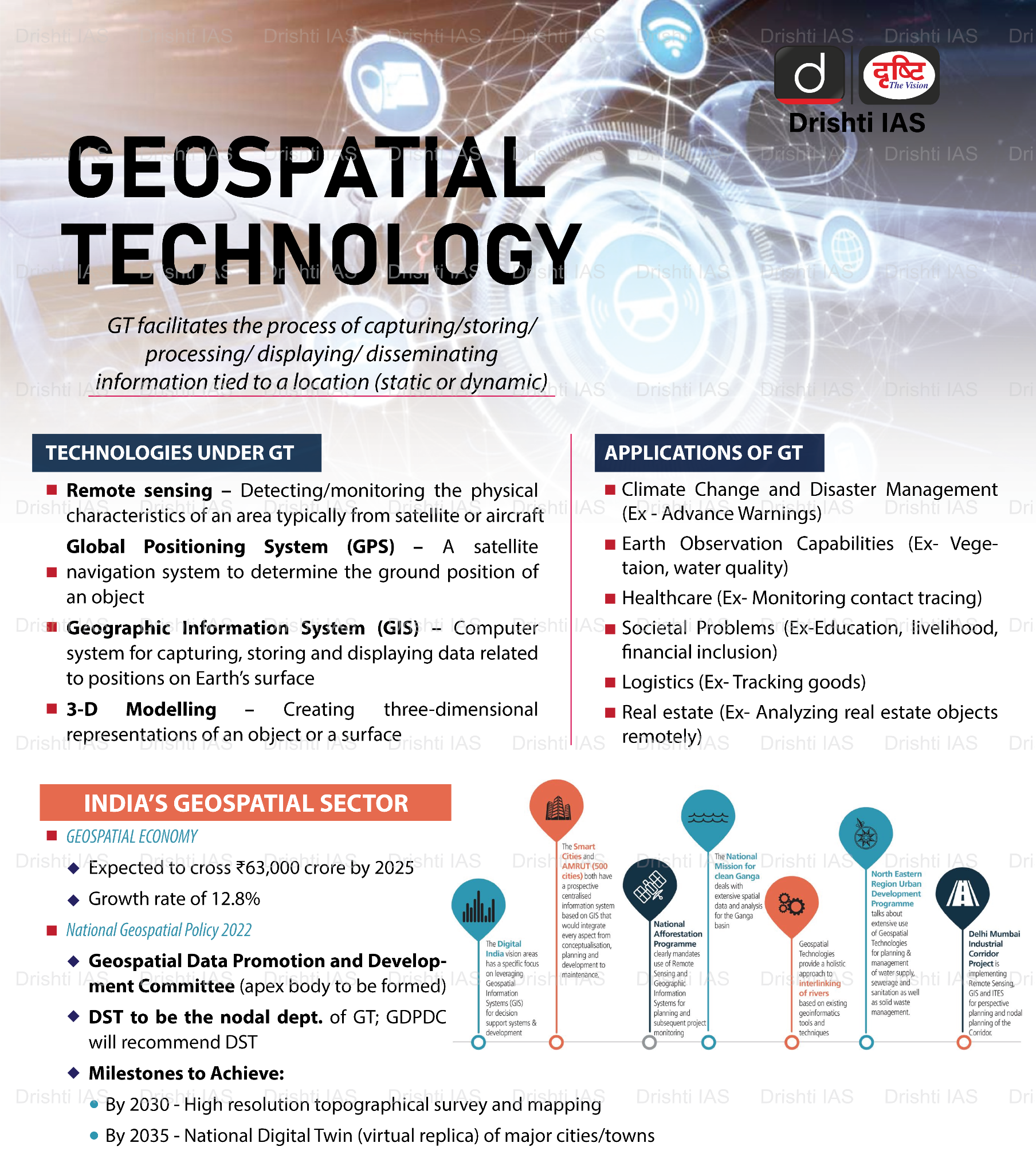
What are the Government Initiatives Related to GIS in India?
- National Geospatial Policy (NGP) 2022: Its objective is to position India as a global leader in the geospatial sector by promoting the use of geospatial data in public and private sectors.
- Its goal is to develop Geospatial infrastructures, Geospatial skill and knowledge, standards, and Geospatial businesses.
- SVAMITVA Scheme: Its objective is to provide property cards and digitize land records in rural areas using GIS and drone-based mapping.
- Its aim is to resolve property disputes, enhance financial inclusion, and support rural planning.
- Utilizes Continuously Operating Reference Stations (CORS) and drone surveys for accurate land mapping
- Bhuvan: The Bhuvan web portal provides extensive and comprehensive access to satellite imagery and geospatial data covering the entire country.
- It supports applications that provide detailed geospatial analysis and mapping features, which in turn facilitate developmental planning, disaster management, inventory management, environmental conservation etc.
- Bharat Maps: Bharat Maps is a multi-layer GIS platform developed by the National Informatics Centre (NIC) to support e-governance and digital infrastructure initiatives in India.
- SOI Online Maps and Data Portal: It is a digital initiative by the Survey of India (SOI), the national mapping agency.
- This portal provides online access to a wide range of topographic and thematic maps, geospatial datasets, and cartographic tools for public and government use.
- Sarthi: This is a Web-based GIS (Web GIS) platform developed to provide interactive geospatial tools and data visualization for informed decision-making across various sectors.
- Gram Manchitra: It is a GIS-based platform developed by the Ministry of Panchayati Raj to empower Panchayati Raj Institutions (PRIs) with spatial planning capabilities.
- Geospatial Energy Map of India: It was launched in 2021 by NITI Aayog in collaboration with the Indian Space Research Organization (ISRO).
- It provides a comprehensive GIS visualization of the country's energy resources and infrastructure.
- It aims to streamline energy sector planning, enhance policy-making, and foster efficiency gains.
What are the Challenges Related to GIS Implementation?
- Inadequate Data Quality: The major challenge in GIS implementation is the availability of accurate and up-to-date data.
- Geospatial data can become outdated due to environmental changes, urbanization, or natural disasters.
- Inaccurate or outdated data, such as obsolete land-use maps or incorrect population figures, can result in flawed analysis and poor decision-making, impacting urban planning and resource distribution.
- High Cost: The ongoing maintenance and software updates also add to the financial burden, making it difficult for many public or private sector entities to fully integrate GIS into their operations.
- The specialized software required for GIS analysis is often expensive, and there are additional costs for high-resolution satellite imagery, GPS equipment, and servers for data storage.
- Lack of Skilled Personnel: Another significant challenge is the lack of skilled professionals trained in GIS technologies.
- GIS implementation requires experts who can handle complex data analysis, map creation, and decision-making processes.
- There is a need for professionals who are proficient in both geospatial technologies and specific application areas such as urban planning, agriculture, or disaster management.
- The shortage of trained GIS professionals can hinder the effective use and adoption of GIS systems in many sectors.
- Privacy and Security Concerns: This includes risks of unauthorized access to sensitive location data, potential misuse of personal and critical infrastructure information, and vulnerabilities to cyberattacks that can compromise data integrity and national security.
How can GIS be Improved in India?
- Enhancing GIS Accuracy Through Advanced Technologies: Establish systems for frequent data collection and real-time updates using modern technologies like IoT sensors, satellite imagery, and drones.
- Use AI and ML algorithms for error detection and data validation to ensure accuracy and consistency in geospatial datasets.
- Open-Source Software: Promote the use of open-source GIS software like Quantum Geographic Information System (QGIS), which reduces the cost burden on organizations, especially in developing countries.
- Training and Capacity Building: Investing in GIS training programs and certifications, with collaboration between universities, institutes, and industry, can ensure a steady flow of skilled professionals.
- Geospatial Investment and Infrastructure: A geospatial investment fund will further boost startups, promote local manufacturing, and enhance India’s global competitiveness in the concerned sector.
- Indigenous Technology and Self-Sufficiency: There is a need for developing indigenous geospatial technologies to reduce reliance on foreign solutions.
- This includes promoting domestic software and hardware development to build a self-reliant geospatial industry in India.
- Data Protection: Strengthen data protection laws and enforce strict cybersecurity protocols for location-based services. Promote transparency and accountability among data handlers to safeguard national and individual interests.
Conclusion
Geographic Information Systems (GIS) are vital for informed decision-making across diverse sectors. With supportive policies, technological integration, and skilled manpower, India can harness GIS for sustainable development. Addressing current challenges will unlock its full transformative potential.
UPSC Civil Services Examination, Previous Year Question (PYQ)
Prelims
Q.1 In the context of space technology, what is “Bhuvan”, recently in the news? (2010)
(a) A mini satellite launched by ISRO for promoting the distance education in India
(b) The name given to the next Moon Impact Probe, for Chandrayaan-II
(c) A geoportal of ISRO with 3D imaging capabilities of India
(d) A space telescope developed by India
Ans: C
Mains
Q.2 Discuss India’s achievements in the field of Space Science and Technology. How the application of this technology helped India in its socio-economic development? (2016)