Perennial Disaster - Floods | 02 Jul 2022
This editorial is based on “Keeping head above water in Silchar” which was published in The Hindu on 02/07/2022. It talks about the floods in Assam, its effect on different spheres of life and suggests measures to tackle it.
For Prelims: Geographical Phenomena, Peninsular Rivers, Flood, Landslide, Topography of India
For Mains: Causes of floods, Impact on life and economy, Measures to tackle, Disaster Management Bodies
The Brahmaputra Valley that encompasses the Northeast part of India witnesses floods almost every year, leaving behind a tale of death and destruction.
Even before the onset of monsoon in Assam this year, never stopping rain has wreaked havoc, with much of Assam submerged, crops destroyed and lakhs displaced.
The Brahmaputra is also critical to the Kaziranga National Park as it is bound by the river on one side. In recent years, however, the extent of devastation due to floods has increased significantly.
Let’s understand how a state is being flooded heavily every year and analyze the factors behind it.
What do We Mean by Flood?
- A flood is an overflow of water that submerges land that is usually dry.
- In the sense of "flowing water", the word may also be applied to the inflow of the tide.
- There are three common type of floods:
- Flash Floods:
- Caused by rapid and extensive rainfalls.
- River Floods:
- Caused when consistente rain or snow melt forces a river to exceed capacity.
- Coastal Floods:
- Caused by storm surges associated with tropical cyclones and tsunami.
- Flash Floods:
- Between 1998 - 2017, 2 Billion people have been affected worldwide due to floods.
Why Assam Gets Flooded Every Year?
- The Brahmaputra factor:
- Assam is situated at the foothills of the Himalayas and comprises two valleys namely Brahmaputra and Barak, named after their names.
- The mighty Brahmaputra river originates from the Himalayas and enters India through Arunachal Pradesh before flowing into the Bay of Bengal.
- It flows through Assam over a length of around 650 km with an average width of 5.46 km, making it the principal river that crisscrosses the floodplains.
- Coming from the Kailash range (high elevation), the river gets highly sedimented by the time it enters Assam (low elevation).
- Due to this flattening of the slope, there is a sudden drop in velocity and the river deposits huge quantities of sediment and other debris collected from hilly terrains on the riverbed, raising its level.
- During summers, the sedimentation increases as soil erodes with the melting of glaciers.
- The Monsoon Factor:
- The monsoon is intense in the Northeast.
- According to the State Disaster Management Authority, annual rainfall averages around 2900 mm with maximum precipitation in June and July.
- The Water Resources Ministry of Assam states that 85% of the annual rainfall in the Brahmaputra basin takes place during the monsoon months.
- Besides, the valley gets a good amount of rainfall in April and May due to thunderstorm activities which account for flooding during heavy rain in June, when the soil is already saturated.
- The monsoon is intense in the Northeast.
- Riverbank Erosion:
- As sedimented rivers move through the state along with their tributaries, they take with them soil and sediment from banks.
- Soil erodes and rivers expand as it gets more area and this results in flooding. This erosion of the land alongside rivers has emerged as a serious problem for Assam:
- A major cause of the internal displacement of people due to the disappearance of villages.
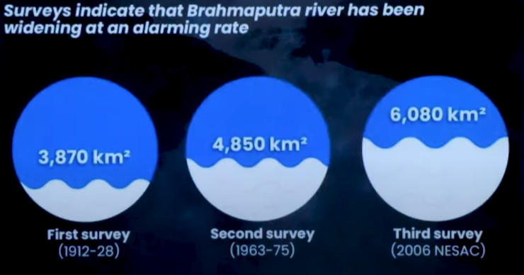
- The width of Brahmaputra has increased up to 15km due to bank erosion at some places in Assam.
- Human intervention
- Construction of Embankments:
- Embankments are constructed to confine the course of a river. This solution, however, has evolved to be an added challenge over time in Assam.
- Construction of embankments first started in Assam in the 1960s to control floods.
- Six decades later, most of these embankments have either outlived their utility or are in bad condition. Many others were washed away.
- Every year, as floods follow monsoon, river water breaches these barriers and inundates houses and land.
- Successive Governments in Assam have spent nearly Rs 30,000 crore on building embankments over the last six decades.
- One such incident is noted in Mahisha Beel, a town in Silchar where people cut the embankment at Bethukandi to drain out excess water into the Barak River that flows down from Manipur and meanders into Bangladesh.
- This is believed to be one of the core reasons for flooding in the Silchar region.
- Embankments led to encroachment of river banks with an increasing number of people building houses and setting up establishments close to the river.
- Population Boom:
- Population boom in the State which has put more pressure on the State’s ecology.
- The population density of Brahmaputra valley has increased from 9-29 people per sq. km. in 1940-41 to 398 per sq. km in the plain areas of Assam as per the 2011 census, according to a report by the Brahmaputra Board.
- The board under the Ministry of Jal Shakti monitors the Brahmaputra and Barak Valley and covers States under the Brahmaputra basin.
- The population density of Brahmaputra valley has increased from 9-29 people per sq. km. in 1940-41 to 398 per sq. km in the plain areas of Assam as per the 2011 census, according to a report by the Brahmaputra Board.
- Population boom in the State which has put more pressure on the State’s ecology.
- Other Factors:
- Other man-made factors like deforestation, hill cutting, encroachments and destruction of wetlands have also worsened the flood situation.
- Construction of Embankments:
- Climate change:
- A Report by the State government states that extreme rainfall events will increase by 38%.
- Heavy rainfall replacing continuous low or normal rainfall during monsoon combined with the melting of glaciers due to rising temperatures will mean:
- Rivers from the Himalayas will be carrying more water and sediment even before they enter Assam where smaller rivers are swelled up due to incessant rainfall.
- This increases the possibility of frequent flash floods in low-lying areas.
- Other Factors:
- Lack of drainage system in the state.
- Unplanned urban growth.
- Construction of Dams, Hydro Projects, Irrigation Projects etc.
How Floods Affect Assam Adversely?
- Kaziranga National Park:
- More than 15% of the Kaziranga National Park has been inundated with the Brahmaputra flowing above the danger level, an official statement noted.
- At least five animals, including a leopard, have been killed in floods in the national park so far this year.
- Although, excessive water is considered beneficial for the park as it would:
- help replenish Kaziranga’s water bodies and maintain its landscape.
- function as a breeding ground for fish.
- help get rid of unwanted plants such as water hyacinth.
- However, large frequent floods have started creating problems for the national park.
- NH-37:
- When the flood water hits a certain level, the animal moves towards safer, higher ground in the Karbi Anglong hills. However, they have to cross NH-37 which cuts across the park, which leads to the killing of animals in road accidents.
- Animals are also killed by poachers who take advantage of their vulnerability.
- When the flood water hits a certain level, the animal moves towards safer, higher ground in the Karbi Anglong hills. However, they have to cross NH-37 which cuts across the park, which leads to the killing of animals in road accidents.
- Human-animal Conflict:
- Animals also move towards villages in floods, this leads to human-animal conflict.
- NH-37:
- More than 15% of the Kaziranga National Park has been inundated with the Brahmaputra flowing above the danger level, an official statement noted.
- Effects on Infrastructure:
- Train services got disrupted as water affected railway tracks at several places.
- All modes of transport went on halt except Boats, which charged as much as ₹100 per 100 m in some areas to make up for their inability to fish or ferry people to rivers for a living.
- Food and potable water is not easily available.
- Roads and bridges have suffered serious damage.
- Almost all the power stations are invariably situated near the rivers because they draw water from the river to cool down the equipment and pump back the hot water into the river.
- The flooding damaged the electricity supply in many districts.
- Effects on Common Lives:
- More than 5,000 villages and croplands have been inundated, with the Brahmaputra river breaching its embankments due to incessant rainfall.
- Heavy rain has triggered landslides in Cachar, Dima-Hasao, Goalpara, Hailakandi, Kamrup (Metro) and Karimganj districts, throwing normal life out of gear.
- The destruction is not limited to humans alone. Some 60,000 animals have been washed away and around 36 lakh were affected in the current wave of floods, according to the ASDMA report.
What Measures Can be Taken in Future Flood Events?
- Information Communication:
- It should be ensured that more credible information is made available so that preparedness can be improved and residents can be alerted.
- Experts have indicated that the region needs more institutionalized and technologically advanced systems to allow for credible and fast warning systems.
- Protecting Kaziranga:
- Emphasis needs to be put on securing animal corridors and ensuring a safe passage to the Karbi hills.
- Need for a landscape-scale conservation approach that recognises the value of the Karbi Anglong hills.
- The highlands of Karbi Anglong, where the animals take refuge, are the lifeline of the park during the floods.
- Need for a landscape-scale conservation approach that recognises the value of the Karbi Anglong hills.
- Emphasis needs to be put on securing animal corridors and ensuring a safe passage to the Karbi hills.
- Constructing Sluice Gates:
- Sluice Gates should be constructed on tributaries of brahmaputra and other rivers like Barak etc. It would prove to be an effective step.
- Sluice Gate’s valves are designed to seal in one direction and commonly are used to control water levels and flow rates in rivers and canals. They also are used in wastewater treatment plants.
- Sluice Gates should be constructed on tributaries of brahmaputra and other rivers like Barak etc. It would prove to be an effective step.
- Other Measures:
- A Centre for Disaster Management should be established in Assam to carry out studies for effective implementation of measures.
|
Drishti Mains Question Assam’s unique topography, climate and socio-economic conditions make it more vulnerable to disasters like floods. Comment. |
UPSC Civil Services Examination, Previous Year Questions (PYQs)
Q. Which of the following is/are tributary/tributaries of Brahmaputra?
- Dibang
- Kameng
- Lohit
Select the correct answer using the code given below:
(a) 1 only
(b) 2 and 3 only
(c) 1 and 3 only
(d) 1, 2 and 3
Ans: (d)
Q. With reference to river Teesta, consider the following statements:
- The source of river Teesta is the same as that of Brahmaputra but it flows through Sikkim.
- River Rangeet originates in Sikkim and it is a tributary of river Teesta.
- River Teesta flows into Bay of Bengal on the border of India and Bangladesh.
Which of the statements given above is/are correct?
(a) 1 and 3 only
(b) 2 only
(c) 2 and 3 only
(d) 1, 2 and 3
Ans: (b)