Landslide near Eravikulam National Park | 08 Aug 2020
Why in News
Recently, landslides have been reported at the Nayamakkad tea estate at Pettimudy which is located about 30 km from Munnar, adjacent to the Eravikulam National Park (ENP), Kerala.
Key Points
- Features of ENP:
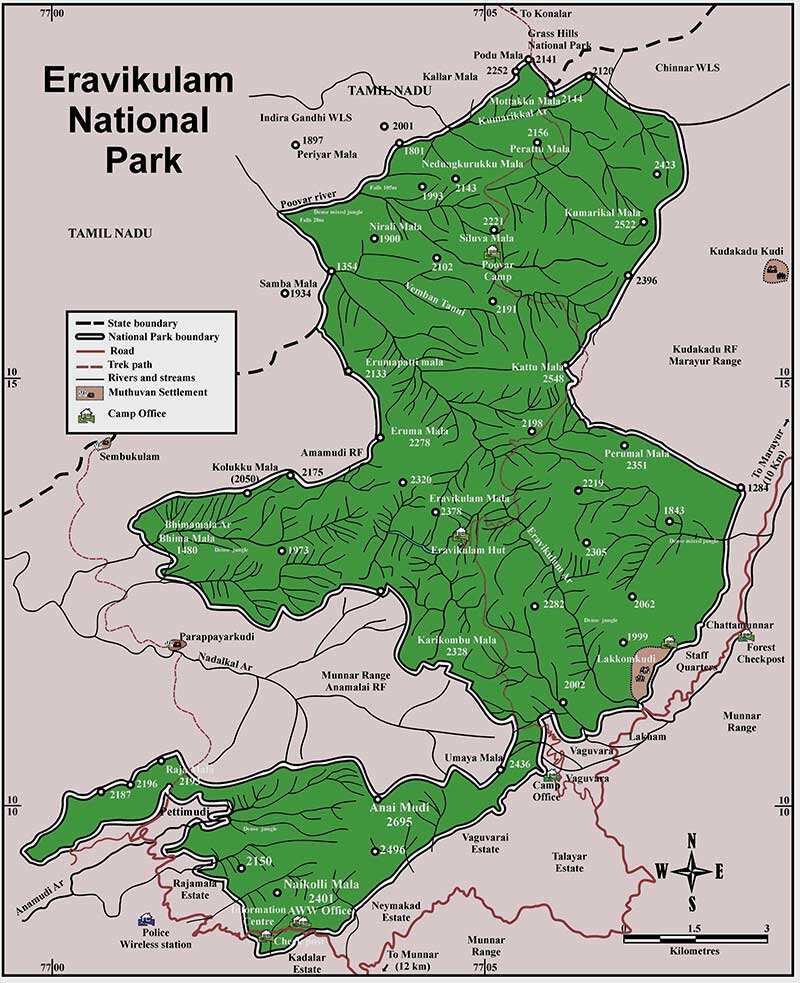
- It is located in the High Ranges (Kannan Devan Hills) of the Southern Western Ghats in the Devikulam Taluk of Idukki District, Kerala.
- It spreads over an area of 97 square km and hosts South India's highest peak, Anamudi (2695 m), in its southern area.
- The Rajamalai region of the park stays open to the public for tourism.
- History:
- The Government of Kerala acquired the area from the Kannan Devan Hills Produce Company under the Kannan Devan Hill Produce (Resumption of lands) Act 1971.
- It was declared as Eravikulam-Rajamala Wildlife Sanctuary in 1975 and was elevated to the status of a National Park in 1978.
- Topography:
- The main body of the park comprises a high rolling plateau (plateau at different elevation or with varying heights) with a base elevation of about 2000 m from mean sea level.
- Three major types of plant communities found in the park are: Grasslands, Shrub Land and Shola Forests (mosaic of montane evergreen forests and grasslands).
- The park represents the largest and least disturbed stretch of unique Montane Shola-Grassland vegetation in the Western Ghats.
- Flora:
- It houses the special Neelakurinji flowers (Strobilanthes kunthianam) that bloom once every 12 years and the next sighting is expected to be in 2030.
- Apart from that, it has rare terrestrial and epiphytic orchids, wild balsams, etc.
- An epiphyte is an organism that grows on the surface of a plant and derives its moisture and nutrients from the air, rain, water or from debris accumulating around it.
- Fauna:
- The park holds the largest viable population of the endangered Nilgiri Tahr (Nilgiritragus hylocrius).
- It has other little known fauna such as Nilgiri Marten, Ruddy Mongoose, Small Clawed Otter, Dusky Striped Squirrel, etc.
- Significance:
- It is regionally important as a catchment area for both east (tributaries of River Pambar) and west (tributaries of River Periyar and Chalakkudy) flowing rivers.
- Locally, it is important for maintaining the climate and providing drinking water to the surrounding estates and for irrigation.
- Proximity: The park is in continuity with the neighboring Chinnar Wildlife Sanctuary, Anamudi Shola National Park, Pampadum Shola National Park, Kurinjimala Sanctuary and Anamalai Tiger Reserve.
Landslides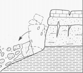
- A landslide is defined as the movement of a mass of rock, debris or earth down a slope. Landslides are a type of mass wasting (a geomorphic process) which denotes any down-slope movement of soil and rock under the direct influence of gravity.
- Causes: Slow weathering of rocks as well as soil erosion, earthquakes and volcanic activity.
- Continent-wise, Asia suffers the maximum damages/losses due to landslides and within that, South-Asian nations are the worst sufferers including India which is one of the worst affected by landslides.