Tapti Basin Mega Recharge Project | 13 May 2025
Why in News?
In a significant step towards ensuring regional water security, the governments of Madhya Pradesh and Maharashtra signed a Memorandum of Understanding (MoU) to jointly implement the Tapti Basin Mega Recharge Project.
Key Points
- About the Project:
- The MoU was signed after the first Madhya Pradesh–Maharashtra Inter-State Control Board meeting in 25 years, marking a joint commitment to sustainably manage inter-State river resources.
- Objective: The project seeks to address the drinking and irrigation water needs of key regions in both States.
- The project plans to divert water from the Tapti River (originating in Betul, MP and called Tapi in Maharashtra) to:
- Serve Nagpur and northeastern Maharashtra for drinking water.
- Support irrigation in southern and southeastern Madhya Pradesh, including Burhanpur and Khandwa districts.
- The project will use 3,362 hectares in Madhya Pradesh without displacing villages or requiring rehabilitation.
- The project plans to divert water from the Tapti River (originating in Betul, MP and called Tapi in Maharashtra) to:
- Irrigation and Land Coverage Targets: The project aims to provide permanent irrigation for:
- 1,23,082 hectares of Burhanpur and Khandwa district of Madhya Pradesh
- 2,34,706 hectares of Jalgaon, Akola, Buldhana, Amravati and Nagpur division in Maharashtra.

- Other Water Sharing Initiatives of MP: This project marks the third major inter-State water project by Madhya Pradesh within a year, after:
- Ken–Betwa link with Uttar Pradesh.
- Parvati–Kalisindh–Chambal link with Rajasthan.
Tapi River
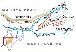
- About: The Tapi River is one of the only three major rivers in India that flow westward, the other two being the Narmada and the Mahi rivers.
- The Narmada and Tapi rivers are the major rivers that flow through rift valleys.
- Origin: Gawilgarh Hills, part of the central Deccan Plateau in south-central Madhya Pradesh.
- States Covered:
- It covers a total basin area of 65,145 sq.km, which is nearly 2% of India’s total geographical area.
- The river flows through three Indian states:
- Maharashtra – 51,504 sq.km. of basin area
- Madhya Pradesh – 9,804 sq.km.
- Gujarat – 3,837 sq.km.
- Geographical Boundaries of the Basin:
- North – Bounded by the Satpura Range
- East – By the Mahadev Hills
- South – By the Ajanta Range and Satmala Hills
- West – Opens into the Arabian Sea
- Major Tributaries: The Tapti River’s three main tributaries—Purna, Girna, and Panjhra, all originating from the south in Maharashtra.
- Hydroelectric Infrastructure:
- The Ukai Dam is a major hydroelectric project built on the Tapi River.
- It plays a key role in irrigation, power generation, and water supply for the surrounding regions.