Great Nicobar Island Project | 15 Sep 2025
Why in News?
Great Nicobar Island (GNI) Project has drawn attention as one of India’s most ambitious infrastructure plans in the Indian Ocean Region (IOR).
- Despite environmental concerns, the project is crucial for turning Great Nicobar into a global maritime hub while considering ecology and tribal welfare.
What is the Great Nicobar Island (GNI) Project?
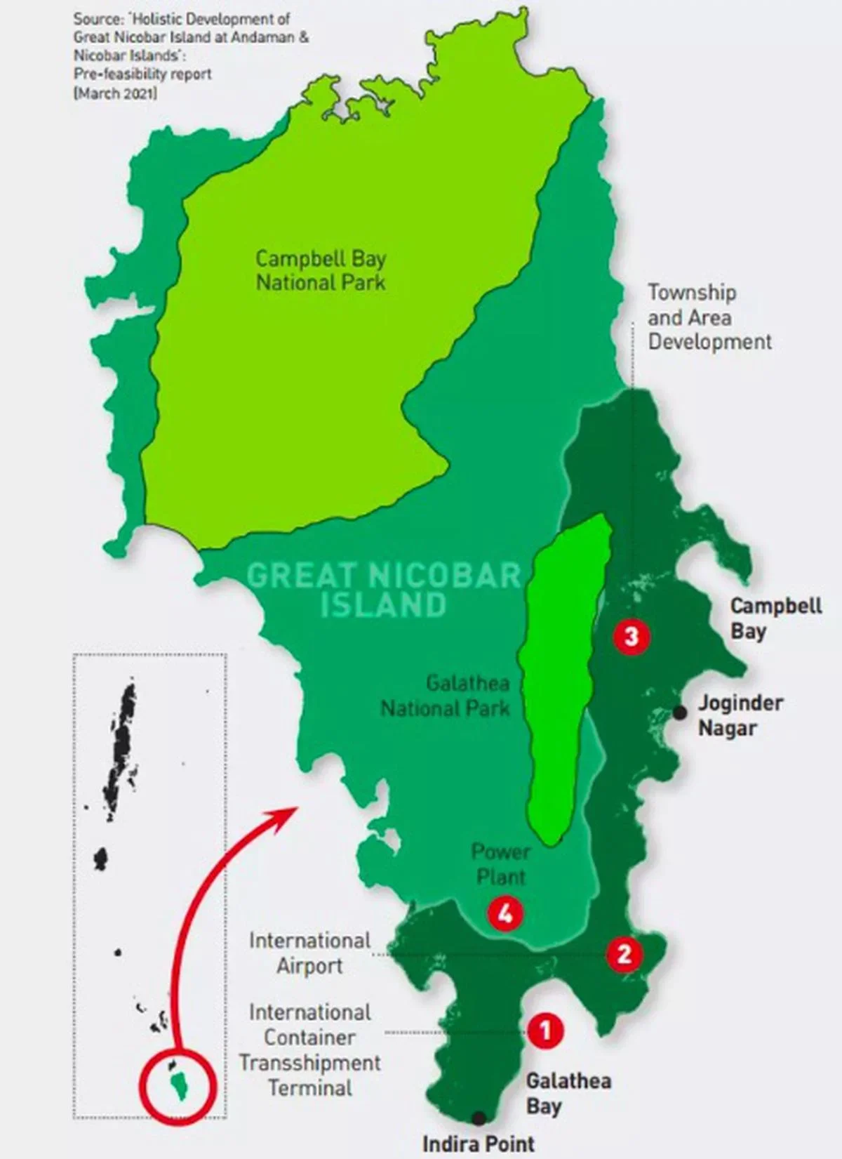
- About: The GNI Project, conceived by NITI Aayog and launched in 2021, aims to build an International Container Transshipment Terminal (ICTT), a greenfield international airport, a township, and a gas–solar power plant.
- It is implemented by Andaman and Nicobar Islands Integrated Development Corporation (ANIIDCO).
- It aligns with India’s Maritime Vision 2030 and is one of the key projects under the Amrit Kaal Vision 2047.
- Strategic Significance:
- Transshipment Hub: The ICTT reduces India’s reliance on foreign ports like Singapore and Colombo, integrating India into global supply chains.
- Greenfield Airport: Enhances civilian connectivity, tourism, and dual-use defence capability.
- Strategic Positioning Advantage: Nicobar’s location near the Malacca, Sunda, and Lombok Straits allows India to monitor vital sea lanes for global trade and energy supply.
- Great Nicobar’s location gives India proximity to Sabang (Indonesia), Coco Island (Myanmar), and the proposed Kra Canal (Thailand), underscoring its central role in Indo-Pacific sea routes.
- Great Nicobar lies almost equidistant from Colombo, Port Klang, and Singapore, placing India at the centre of regional sea trade.
- Maritime Security: The Andaman & Nicobar Islands serve as India’s first line of maritime defence and share sea boundaries with Myanmar, Thailand, Indonesia, and Bangladesh, giving India a vast exclusive economic zone and continental shelf under United Nations Conference on the Laws of the Sea, 1982 (UNCLOS).
- GNI strengthens India’s naval reach in the Indo-Pacific, countering piracy, trafficking, terrorism, and great-power rivalries.
- Positions India as a proactive maritime power amidst rising presence of China and other navies in the IOR.
- Policy Alignment: Supports Act East Policy (2014) and the QUAD’s Indo-Pacific strategy, strengthening India’s role in regional security.
- Tribal Safeguards: Large-scale development in GNI is permitted only after consultations with the Ministry of Tribal Affairs, Directorate of Tribal Welfare and Andaman Adim Janjati VikasSamiti (AAJVS), as mandated by the Jarawa Policy (2004) and Shompen Policy (2015).
- The policies appoint AAJVS as the trustee of Particularly Vulnerable Tribal Groups (PVTGs) and ensure the Shompen community’s welfare is given top priority in all major projects.
- In line with this, the Empowered Committee, after mandatory consultation with the National Commission for Scheduled Tribes (NCST) under Article 338A(9), confirmed that tribal interests will remain protected.
- The policies appoint AAJVS as the trustee of Particularly Vulnerable Tribal Groups (PVTGs) and ensure the Shompen community’s welfare is given top priority in all major projects.
- Environmental Safeguards: The Project incorporates strict environmental safeguards, following the Environmental Impact Assessment (EIA) Notification, 2006, and based on detailed EIAs and an Environmental Management Plan (EMP).
- To protect wildlife, 8 corridors have been planned to ensure the safe movement of arboreal animals, snakes, crabs, and crocodiles, minimizing ecological disruption during development.
- To compensate for tree felling caused by the GNI project, compensatory afforestation is planned in Haryana, as the Andaman & Nicobar Islands already have over 75% forest cover.
Great Nicobar Island
- The Andaman and Nicobar Islands comprise 836 islands, divided by the Ten Degree Channel into the Andamans (north) and Nicobars (south).
- Great Nicobar, the largest Nicobar island (910 sq km of rainforest). It hosts Indira Point, India’s southernmost tip, just 90 nautical miles from Sumatra (Indonesia).
- Great Nicobar has two national parks, a biosphere reserve, small populations of the Shompen and Nicobarese tribal peoples, and a few thousand non-tribal settlers.
- Great Nicobar Biosphere Reserve was included in the list of Man and Biosphere (MAB) Program of UNESCO in 2013.
Conclusion
The Great Nicobar Island Project is not merely an infrastructure plan but a strategic-economic multiplier. It secures India’s maritime future, reduces logistical dependence on foreign ports, and unlocks regional growth, thereby positioning India as a major player in the Indo-Pacific.
Click here to Read: Concerns Associated with the Great Nicobar Island Project
|
Drishti Mains Question: Q. Discuss the role of the Great Nicobar Island Project in India’s Maritime Vision 2030 and its alignment with the Amrit Kaal Vision 2047. |
UPSC Civil Services Examination, Previous Year Question (PYQ)
Prelims
Q. Consider the following statements: (2018)
- The Barren Island volcano is an active volcano located in the Indian territory.
- Barren Island lies about 140 km east of Great Nicobar.
- The last time the Barren Island volcano erupted was in 1991 and it has remained inactive since then.
Which of the statements given above is/are correct?
(a) 1 only
(b) 2 and 3
(c) 3 only
(d) 1 and 3
Ans: (a)
Q. Which one of the following pairs of islands is separated from each other by the ‘Ten Degree Channel’? (2014)
(a) Andaman and Nicobar
(b) Nicobar and Sumatra
(c) Maldives and Lakshadweep
(d) Sumatra and Java
Ans: (a)
Mains
Q. Environmental impact assessment studies are increasingly undertaken before the project is cleared by the government. Discuss the environmental impacts of coal- fired thermal plants located at Pitheads.(2023)