Floods Triggered by Rising Narmada River in MP | 07 Jul 2025
Why in News?
Heavy rains in Madhya Pradesh have resulted in the Narmada River overflowing, causing floods in several districts, particularly Shahdol.
- The rising water levels have prompted authorities to open the gates of the Bargi Dam in Jabalpur, raising concerns of further flooding.
Key Points
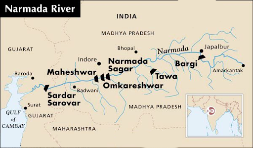
- Narmada River
- About:
- The Narmada is a major westward-flowing river in central India, traversing the states of Madhya Pradesh, Gujarat, and Maharashtra.
- The river is fed by 41 tributaries and historically served as a trade and cultural route between the Arabian Sea and the Ganges valley.
- Source and Course of the River:
- The Narmada originates from the Maikala Range in eastern Madhya Pradesh at an elevation of 3,500 feet (1,080 m) near the Chhattisgarh border.
- It flows through Mandla, Jabalpur, and the Marble Rocks Gorge, entering a rift valley between the Vindhya and Satpura ranges.
- The river crosses into Gujarat before draining into the Gulf of Khambhat through a 13-mile (21 km) wide estuary.
- The Narmada drains the northern slopes of the Satpura Range and flows through varied terrains, including the Dhuandhar Falls near Jabalpur.
- Water Resource Development:
- The Narmada is crucial for hydropower generation, irrigation, and drinking water supply across multiple states.
- Major dams on the river include Sardar Sarovar Dam (Gujarat), Indira Sagar Dam (Punasa, MP), Omkareshwar Dam, Bargi Dam, and Maheshwar Dam.
- Narmada Water Dispute:
- Since the 1960s, several states have contested over the river’s water sharing and dam construction.
- In 1969, a tribunal was established to resolve disputes. The Narmada Control Authority (NCA), formed in 1980, implements the tribunal's decisions with representatives from Madhya Pradesh, Gujarat, Maharashtra, Rajasthan, and the Union government.
- Narmada Bachao Andolan (NBA):
- The Sardar Sarovar Dam faced strong opposition due to large-scale displacement.
- The NBA, led by Medha Patkar and Baba Amte, demanded proper rehabilitation for affected communities.
- Their efforts led to delays, World Bank withdrawal in 1993, and intervention by the Supreme Court.
- In 2000, the court allowed the dam’s completion in phases, conditional on the resettlement of displaced populations.
- About:
- Causes of Floods in India:
|
Cause of Floods |
Explanation |
|
Heavy and Erratic Rainfall |
Excessive monsoon rains (June–September) often exceed the soil's absorption capacity and overwhelm drainage systems. |
|
Melting of Glaciers |
Rising temperatures accelerate glaciers and snowmelt in the Himalayas, increasing river discharge downstream. |
|
Cyclones and Coastal Storms |
Severe cyclones bring heavy rainfall, storm surges, and strong winds, flooding coastal and adjoining inland areas. |
|
River Overflow and Breaches |
Rivers exceed their banks due to upstream rain or reduced downstream discharge capacity. |
|
Unplanned Urbanisation |
Rapid, unregulated growth of cities and slums reduces natural drainage and increases vulnerability to urban floods. |
|
Poor Management of Dams and Barrages |
Inadequate regulation and emergency release from dams during heavy rain can worsen flooding downstream. |
|
Impact of Climate Change |
Global warming is leading to erratic and more intense rainfall patterns, raising flood risk. |
|
Inadequate Drainage Infrastructure |
Poorly maintained or clogged drains, especially in urban areas, lead to severe waterlogging during rain. |
- Solutions for Flood Management in India:
- Interlinking of Rivers (ILR) Programme:
- The ILR programme aims to divert surplus water from flood-prone rivers to water-deficient regions, thereby balancing water availability.
- Example: The Ken-Betwa link project, a flagship initiative, is vital for water security and socio-economic upliftment in the Bundelkhand region.
- Reservoir Construction:
- Reservoirs store excess water during high rainfall and release it gradually to control downstream flood peaks.
- Example: The Bhakra Nangal Dam on the Sutlej River helps in flood moderation, power generation, and irrigation.
- Coastal Flood Management:
- Mangroves act as natural barriers against storm surges and coastal flooding, as witnessed during the 2004 Tsunami.
- The MISHTI initiative, launched in the Union Budget 2023–24, promotes large-scale mangrove plantations along India’s coasts.
- Flood Forecasting and Early Warning Systems:
- These systems use meteorological and hydrological data to predict floods and issue timely alerts.
- Example: The Central Water Commission (CWC) runs a nationwide network of forecasting stations issuing daily flood bulletins.
- Floodplain Zoning:
- This involves regulating land use in flood-prone zones to reduce vulnerability and preserve natural flood absorbers like wetlands.
- Example: NDMA’s floodplain zoning guidelines categorize land into four risk-based zones—prohibited, restricted, regulated, and free.
- Flood Insurance Schemes:
- Flood insurance provides compensation for losses in exchange for a premium, encouraging risk mitigation among vulnerable populations.
- Example: The Pradhan Mantri Fasal Bima Yojana (PMFBY) covers crop losses due to floods and other natural calamities.
- Interlinking of Rivers (ILR) Programme:
Bargi Dam
- About:
- Bargi Dam, located in Jabalpur, is one of the key dams among the 30 constructed on the Narmada River.
- It plays a crucial role in supplying water to Jabalpur city and its adjoining regions.
- Major Irrigation Projects:
- Two major irrigation initiatives—Bargi Diversion Project and Rani Avantibai Lodhi Sagar Project—have been developed based on this dam.
- These projects have enhanced agricultural productivity and improved water availability in the region.
- Emerging Tourist Destination:
- Over the years, Bargi Dam has evolved into a popular tourist attraction in Jabalpur, drawing visitors for its scenic views and recreational potential.