Jet Streams
What is a Jet Stream?
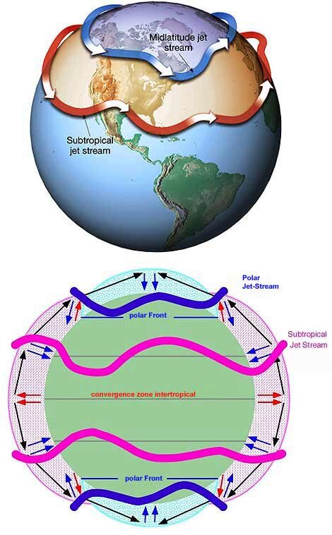
- The Jet Stream is a geostrophic wind blowing horizontally through the upper layers of the troposphere, generally from west to east, at an altitude of 20,000 - 50,000 feet.
- Jet Streams develop where air masses of differing temperatures meet. So, usually surface temperatures determine where the Jet Stream will form.
- Greater the difference in temperature, faster is the wind velocity inside the jet stream.
- Jet Streams extend from 20 degrees latitude to the poles in both hemispheres.
Genesis of Jet Streams
The genesis of the Jet-streams is provided by three kinds of gradients:
- Thermal gradient between pole and equator
- Pressure gradient between pole and equator
- Pressure gradient between surface and subsurface air over the poles.
Where does it actually begin?
- Air when warmed in the tropics, around the equator, fuel the Jet Stream as it rises. Hitting the tropopause at about 58,000 feet (the layer of the atmosphere separating the troposphere from the stratosphere), it is drawn toward the colder air at the north and south poles.
Types of Jet Streams
- Sub Tropical Jet Streams are best developed in winter and early spring. Their maximum speed approaches 300 knots which are associated with the merger with polar-front jets. A subsidence motion accompanies subtropical jets and gives rise to predominantly fair weather in areas they pass over. Sometimes they drift northward and merge with a polar-front jet.
- Tropical Easterly Jet Stream occurs near the tropopause over Southeast Asia, India, and Africa during summer. This jet implies a deep layer of warm air to the north of the jet and colder air to the south over the Indian Ocean. The difference in heating and cooling and the ensuing pressure gradient is what drives this jet.
- Polar-Night Jet Stream meanders through the upper stratosphere over the poles. They are present in the convergence zone above the sub polar low pressure belt.
Climatic Significance of Jet Stream
- At times, Jet Streams bring about some moisture to the stratosphere, leading to the formation of Noctilucent clouds (tenuous cloudlike phenomena in the upper atmosphere which are made of ice crystals visible in a deep twilight.)
- Plays a significant role in the onset and withdrawal of monsoon winds.
- Known to have brought some ozone depleting substances to stratosphere which result in ozone layer depletion.
- Intensifies alternative cyclonic and anticyclonic conditions with the crust and trough formation in its movement.
- When the air mass is moving, it undergoes alternate expansion and compression which means that it is associated with alternative high pressure and low pressure.
Characteristics of Jet Streams
- Its genesis is associated with the thermal contrast of air cells, for example Hadley cell, Ferrel cell.
- The meandering or the whirl movement of the Jet Stream is called ‘Rossby Wave’.
- Equatorial extension of the Jet Stream is more in winter because of the southern shift of the pressure belts.
- During winters, the thermal contrast increases and the intensity of the high pressure centre at the pole increases. It intensifies the formation of Jet Streams, its extension as well as its velocity.
Indian Monsoon Mechanism and the Role of Sub Tropical Jet Streams
- The burst of monsoons depends upon the upper air circulation which is dominated by Sub Tropical Jet Streams (STJ).
- The south west monsoon coming in India is related to tropical easterly stream. It blows between 8 degree- 35 degree North latitudes.
- The north east monsoon (winter monsoon) is related to the subtropical westerly Jet Stream which blows between 20 degree and 35 degree latitudes in both hemispheres.
Seasonal Migration of STJ
- In winter, STJ flows along the southern slopes of the Himalaya and in summer shifts northwards dramatically, flowing along the edge of Himalayas in early June and in late summer (July-August) along the northern edge of the Tibetan Plateau.
- The periodic movement of the Jet Stream often indicates the onset and subsequent withdrawal (STJ returns back to its position – south of Himalayas) of the monsoon.
- Northward movement of the subtropical jet is the first indication of the onset of the monsoon over India.
STJ in Summer
- With the beginning of summer, the STJ [upper westerlies] start their northward march.
- The weather over northern India becomes hot, dry and squally due to larger incoming solar radiation and hot winds like loo.
- Over India, the Equatorial Trough (ITCZ) moves northwards with the weakening of the STJ south of Tibet, but the burst of the monsoon does not take place until the upperair circulation has switched to its summer pattern.
- By the end of May the southern jet breaks and later it is diverted to the north of Tibet Plateau. There is sudden burst of monsoons (the ridge moves northwards into Central Asia, the high pressure zone over north-west India moves northwards into Central Asia making way for south-west monsoon winds).
- The clockwise cyclic origin in the middle of the troposphere begins in the winds rising up from the plateau of Tibet after it becomes too hot. While going up separates near tropopause. One of these blows in the form of the easterly Jet Stream towards the equator and the other blows in the form of the westerly Jet Stream towards the poles.
- Western and eastern jets flow to north & south of Himalayas respectively. The eastern jet becomes powerful and is stationed at 15° N latitude.
- The easterly winds become very active in the upper troposphere and they are associated with westerly winds in the lower troposphere (south-west monsoon winds).
- This results in more active southwest monsoon and heavy rainfall is caused. The plateau of Tibet and central Asia becoming too hot is considered for its origin.
- It is to be noted that the westerly Jet Stream begins to settle down in the Arabian sea by blowing in the south west direction and also creates a very high pressure belt there. Inversely, when this hot Jet Stream blows over the Indian sub continent, it pulls up the surface air and creates a very low pressure there. To fill up the low pressure, winds from high pressure area of the Arabian Sea begins to blow towards in the north east direction- known as the southwest monsoon.
STJ in Winters
- The winter subtropical westerly Jet Stream blows from the west to the east in the entire west and middle Asia
- It is bifurcated by the Himalayan ranges and Tibetan Plateau. One of the branch blows parallel to the plateau from the north while the other moves towards the east in the south of the Himalayas.
- The western disturbance which enter the Indian subcontinent in winter are brought by these westerly winds.
- The southern branch blows to the south of the Himalayan ranges along 25° north latitude.
How Does It Trigger The North East Monsoon?
- The westerly Jet Stream, a cold wind which pushes down wind to the surface creating a high pressure on the surface.
- Dry winds from this high pressure area (north western part of India) start blowing towards the low pressure area (Bay of Bengal).
- These winds in turn bring cold waves in winter in the northern part of the country including UP and Bihar.
- After reaching the Bay of Bengal, westerly under the influence of Ferrel’s cell take the form of north east monsoon.
- When this wind reaches the coast of Tamil Nadu, it causes rainfall with the humidity received from the Bay of Bengal.