Weather Forecasting | 16 Nov 2021
Why in News
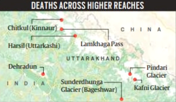
Recently, 21 trekkers died at the Lamkhaga Pass trek in four mountaineering and trekking expeditions which once again puts the spotlight on the importance of right weather forecasting.
- Lamkhaga Pass is a high altitude pass in Garhwal Himalayas (Uttarakhand) which connects with Sangla in Himachal Pradesh. Due to its altitude and remoteness, it is considered one of the toughest treks in the Himalayas (Uttrakhand).
Key Points
- Weather Forecasting:
- It is the prediction of the weather through application of the principles of physics, supplemented by a variety of statistical and empirical techniques.
- In addition to predictions of atmospheric phenomena themselves, weather forecasting includes predictions of changes on Earth’s surface caused by atmospheric conditions - e.g., snow and ice cover, storm tides, and floods.
- Need:
- For Military: During the war the military can plan their battles by featuring in the expected weather condition to maximize the chance of winning the war.
- For Minimizing Losses: It enables people to plan and take precautions against various natural calamities such as floods and typhoons so as to minimize their effects.
- For Farmers: Enables farmers to adjust their farming activities to suit the expected weather condition.
- For Transport: Weather forecasting greatly influences transport, especially in air and water. Aircraft take-off and landing can be affected by weather whereas storms and strong winds greatly affect water travel.
- For Tourists: It can help to guide and encourage tourists to visit certain areas.
- Weather Forecasting Methods:
- Weather forecasters rely on a massive chunk of data to design computer models and simulations that help predict an incoming change in the weather.
- India Meteorological Department (IMD) uses the INSAT series of satellites hovering in the geosynchronous orbit along with the Real-Time Analysis of Products and Information Dissemination (RAPID), a weather data explorer application, that acts as a gateway and provides quick interactive visualisation along with 4-Dimensional analysis capabilities.
- The forecasters use data generated by the satellites around cloud motion, cloud top temperature, water vapour content that help in rainfall estimation, weather forecasting, and provide the genesis of cyclones and their direction.
- Apart from tracking satellite data, IMD collaborates with ISRO for ground-based observations from the Automatic Weather Stations (AWS), the Global Telecommunication System (GTS) that measure temperature, sunshine, wind direction, speed and humidity.
- Meanwhile, the Agro-meteorological Tower (AGROMET) and Doppler Weather Radar (DWR) systems augment the observations.
- In 2021, IMD adopted a new strategy for issuing monthly and seasonal operational forecasts for the southwest monsoon rainfall by modifying the existing two-stage forecasting strategy.
- The new strategy is based on the existing statistical forecasting system and the newly developed Multi-Model Ensemble (MME)-based forecasting system.
- The MME approach uses the coupled global climate models (CGCMs) from different global climate prediction and research centres, including IMD’s Monsoon Mission Climate Forecasting System (MMCFS) model.
- All these technological strides have been possible since the National Monsoon Mission (NMM) was initiated in 2012 with a budgetary allocation of Rs 551 crore and the broad objective to set up a dynamical prediction system for seasonal forecast and to improve the monsoon forecasting skills in the country.
- Issues Related to Weather Forecasting:
- The weather forecasts at times go wrong due to the unpredictability of changes in ocean currents that are responsible for affecting global weather systems.
- For India, the Bay of Bengal acts as the buffer that affects the weather across the country.
- The dynamic models of weather forecasting are based on certain assumptions and it is not possible to incorporate all components of nature accurately in the dynamical models and that is the first reason why sometimes forecasts can go wrong.
- A dynamic weather prediction model involves 3D mathematical simulation of the atmosphere on a computer.
- The errors in forecasts can also crop up due to errors in the initial input given to the models.
- The weather forecasts at times go wrong due to the unpredictability of changes in ocean currents that are responsible for affecting global weather systems.
Way Forward
While India depends on satellite data and computer models, the UK has moved ahead with integrating supercomputers into the forecasting that collect and visualise data from satellites. These supercomputers can process petaflops of data in seconds, effectively speeding up the process and enhancing accuracy. In time, the system is headed towards further enhancement and experts are hopeful that predictions will consistently improve.