Tapi-Par-Narmada Link Project | 12 Mar 2022
For Prelims: Tapi-Par-Narmada Link Project, Ken-Betwa.
For Mains: Inter-Linking of Rivers Programme and related challenges, Water Resources.
Why in News?
Recently, some tribals have intensified their protest against the Par-Tapi-Narmada river linking project after it was mentioned in the budget speech (2022-23) of the finance minister.
What is the Background?
- These projects had been sanctioned in 2010, when a tripartite agreement was signed between the Union government, Gujarat and Maharashtra.
- The Finance Minister in her Budget Speech said that five river linking projects will be taken up after consensus among states.
- The projects are Damanganga-Pinjal, Par-Tapi-Narmada, Godavari-Krishna, Krishna-Pennar and Pennar-Cauveri.
- The Ken-Betwa is the first project under the government's National Perspective Plan for river inter-linking.
- The National River Linking Project (NRLP) formally known as the National Perspective Plan, envisages the transfer of water from water 'surplus' basins where there is flooding, to water 'deficit' basins where there is drought/scarcity, through inter-basin water transfer projects.
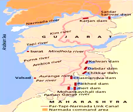
What is the Par-Tapi-Narmada River Linking Project?
- Par Tapi Narmada Link proposes to transfer water from the water surplus regions of Western Ghats to the water deficit regions of Saurashtra and Kutch (Gujarat).
- The link project includes seven reservoirs proposed in north Maharashtra and south Gujarat.
- The water from the seven proposed reservoirs would be taken through a 395 km long canal to take over a part of the command of the on-going SardarSarovar Project (on Narmada), while irrigating small enroute areas.
- The seven dams proposed in the scheme are Jheri, Mohankavchali, Paikhed, Chasmandva, Chikkar, Dabdar and Kelwan.
- This would save SardarSarovar water which will be used to extend irrigation in Saurashtra and Kutch region.
- The link mainly envisages construction of seven dams, three diversion weirs, two tunnels, 395 km long canal, 6 power houses and a number of cross-drainage works.
What will be the Benefits of the Project?
- Besides providing irrigation benefits to the enroute command and Narmada command, the link will generate hydropower of the order of 93.00 Mkwh through the power houses installed at four dam sites.
- The reservoirs will also provide flood relief to the people residing in downstream areas.
What do we know about Narmada River?
- Narmada is the largest west flowing river of the peninsular region flowing through a rift valley between the Vindhya Range on the north and the Satpura Range on the south.
- It rises from Maikala range near Amarkantak in Madhya Pradesh.
- It drains a large area in Madhya Pradesh besides some areas in the states of Maharashtra and Gujarat.
- The river near Jabalpur (Madhya Pradesh) forms the DhuanDhar Falls.
- There are several islands in the estuary of the Narmada of which Aliabet is the largest.
- Major Tributaries: Hiran, Orsang, the Barna and the Kolar.
- The major Hydro Power Projects in the basin are Indira Sagar, Sardar Sarovar etc.
What do we know about the Tapi River?
- Another important westward flowing river originates from the Betul district of Madhya Pradesh in the Satpura ranges.
- It flows in a rift valley parallel to the Narmada but is much shorter in length.
- Its basin covers parts of Madhya Pradesh, Gujarat and Maharashtra.
What do we know about the Par River?
- Par River is a river in Gujarat with its source near wadpada village in Nashik Maharashtra.
- It flows into the Arabian Sea.
PYQ
Recently, linking of which of the following rivers was undertaken? (2016)
(a) Cauvery and Tungabhadra
(b) Godavari and Krishna
(c) Mahanadi and Sone
(d) Narmada and Tapti
Ans: (b)
What is the Inter-Linking of Rivers Programme?
- Aim:
- The InterLinking of Rivers programme (ILR) programme is aimed at linking different surplus rivers of the country with deficient rivers so that the excess water from surplus regions could be diverted to deficient regions.
- Need:
- Reducing Regional Imbalance: India depends on monsoon rains that are erratic as well as regionally imbalanced. Interlinking of rivers will reduce the amount of surplus rain and river water which flows into the sea.
- Irrigation for Agriculture: Interlinking can provide a solution to the rain-fed irrigation problems of Indian agriculture through the transfer of surplus water to deficit regions.
- Reducing Water Distress: This can help in mitigating the effect of drought and floods to a certain extent.
- Other Benefits: Hydropower generation, Round the year navigation, Employment generation, Ecological benefits as dried up forests and lands will be replenished.
- Challenges:
- Environmental Costs: The project threatens to obstruct the natural ecology of rivers.
- Climate Change: In interlinking systems, it is assumed that the donor basin has surplus water that can be made available to the recipient basin.
- The whole concept goes for a toss if this basic assumption goes haywire for any system due to climate change.
- Economic Costs: It is estimated that river interlinking will be a huge fiscal burden on the Government.
- Socio-Economic Impact: It is estimated that the network of canals extending to about 15000 km would displace about 5.5 million people, mostly tribals and farmers.
Way Forward
- India needs to conserve every drop of water, reduce wastage, equitable distribution of resources and at the same time enhance groundwater. So the small scale simple things have to be tried.
- Local solutions (like better irrigation practice) and watershed management, should be focused on.
- The government should alternatively consider the National Waterways Project (NWP) which “eliminates” friction between states over the sharing of river waters since it uses only the excess flood water that goes into the sea unexploited.
PYQ
The Narmada river flows to the west, while most other large peninsular rivers flow to the east. Why? (2013)
- It occupies a linear rift valley.
- It flows between the Vindhyas and the Satpuras.
- The land slopes to the west from Central India.
Select the correct answer using the codes given below:
(a) 1 only
(b) 2 and 3
(c) 1 and 3
(d) None
Ans: (a)