Seismometers Defunct in Earthquake-Prone Zones | 30 Nov 2019
Why in News
20 out of 35 seismometers and accelerographs in earthquake prone zones (Seismic zone III and IV) of Maharashtra were found defunctioning.
- The seismometer is an instrument used to measure and record earthquakes,whereas accelerographs prints the intensity of earthquakes.
- The seismic zone III and zone IV fall under moderate and strong earthquake categories under Earthquake prone zones in India.
Seismic Waves
- Vibrations from an earthquake are categorised as P or S waves. They travel through the Earth in different ways and at different speeds. They can be detected and analysed.
- P-waves (P stands for primary)
- These are the first waves detected by seismograph.
- These are longitudinal waves i.e.they vibrates along the same direction as it travels.
- Other examples of longitudinal waves include sound waves and waves in a stretched spring.
- S-waves (S stands for secondary)
- These waves arrive at the detector after primary waves.
- These are transverse waves i.e. they vibrates at a right angle to the direction in which they travel.
- Other examples of transverse waves include light waves and water waves.
- P-waves (P stands for primary)
- Both types of seismic waves can be detected near the earthquake centre but only P-waves can be detected on the other side of the Earth.
- P-waves can travel through solids and liquids (since they are longitudinal waves) whereas S-waves can only travel through solids (as they are transverse waves). This means the liquid part of the core blocks the passage of S-waves.
- The earthquake events are scaled either according to the magnitude or intensity of the shock.
- The magnitude scale is known as the Richter scale. The magnitude relates to the energy released during the earthquake which is expressed in absolute numbers, 0-10.
- The intensity scale or Mercalli scale takes into account the visible damage caused by the event. The range of intensity scale is from 1-12.
Earthquake Prone Zones in India
- Earthquake is the violent shaking of the ground due to the release of accumulated stress of the moving lithospheric or crustal plates.
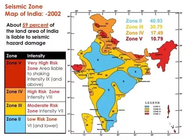
- Over 59 % of India’s land area is under threat of moderate to severe earthquakes.
- Bureau of Indian Standards, based on the past seismic history, divided the country into four seismic zones, viz. Zone II, III, IV and V.
- The regions away from the Himalayas and other inter-plate boundaries were considered to be relatively safe from damaging earthquakes.
- However, occurrence of the Killari earthquake in Maharashtra (1993) resulted in revision of the seismic zoning map in which the low hazard zone or Seismic Zone I was merged with Seismic Zone II. Thus Zone I does not appear in mapping.
- Zone V is the most seismically active region, while zone II is the least active region.
- The zones are divided on the basis of Modified Mercalli (MM) intensity, which measures the impact of earthquakes.
- The area covered under different seismic zones include,
- Zone II:
- It falls under low intensity zone.
- It covers 40.93% area of the country.
- It comprises of major parts of peninsular region and Karnataka Plateau.
- Zone III :
- It falls under moderate intensity zone.
- It covers 30.79% area of the country.
- It comprises of Kerala, Goa, Lakshadweep islands, remaining parts of Uttar Pradesh, Gujarat and West Bengal, Parts of Punjab, Rajasthan, Madhya Pradesh, Bihar, Jharkhand, Chhattisgarh, Maharashtra, Odisha, Andhra Pradesh, Tamil Nadu and Karnataka.
- Zone IV :
- It falls under severe intensity zone.
- It covers 17.49% area of the country.
- It comprises of remaining parts of Jammu and Kashmir, Himachal Pradesh, National Capital Territory (NCT) of Delhi, Sikkim, Northern Parts of Uttar Pradesh, Bihar, West Bengal, parts of Gujarat, small portions of Maharashtra near the west coast and Rajasthan.
- Zone V :
- It falls under very severe intensity zone.
- It covers 10.79% area of the country.
- It comprises of the entire northeastern India, parts of Jammu and Kashmir, Himachal Pradesh, Uttarakhand, Rann of Kutch in Gujarat, part of North Bihar and Andaman & Nicobar Islands.
- Zone II: