Pre-Eruption Warning Signals at Volcanoes | 21 Apr 2022
For Prelims: Volcanoes, Whakaari Volcano, Ruapehu Volcano, Displacement Seismic Amplitude Ratio, Seismic Waves.
For Mains: Volcanoes.
Why in News?
Recently, new research detected pre-eruption warning signals at Whakaari White Island and other active volcanoes, majorly from New Zealand.
What is the New Research about?
- Every volcano behaves differently: some have crater lakes while others are "dry", they have diverse magmas and rise to different elevations.
- Despite these differences volcanoes such as Whakaari, Ruapehu and Tongariro in New Zealand could be driven to eruption by common processes in the shallow subsurface below their craters.
- In the new research, machine learning was used to sift through 40 years of seismic data from the New Zealand volcanoes and three others around the world, listening for frequencies that track the depth where gas, magma or water are moving or building up.
- Researchers saw one pattern repeatedly in the days before all the known Whakaari eruptions over the past decade, and most Ruapehu and Tongariro ones.
- This pattern is a slow strengthening of a quantity called Displacement Seismic Amplitude Ratio (DSAR), which peaks a few days before each event.
- DSAR is a ratio that compares the "activity" of fluids (gas, hot water, steam) at the volcano's surface to those several hundred metres deep. When DSAR increases, surface fluids are quiet, but deep ones are still actively moving and circulating vigorously below ground.
- Seismic waves are the waves of energy caused by earthquakes or an explosion. They are the energy that travels through the earth and is recorded on seismographs.
- This type of analysis is so new that the researchers have not had many chances to test how reliable the DSAR and other automated measures are for forecasting.
What are Whakaari and Ruapehu?
- Whakaari:
- Whakaari/White Island is in the Bay of Plenty, 43 miles west of Cape Runaway, eastern North Island, New Zealand is an active volcano.
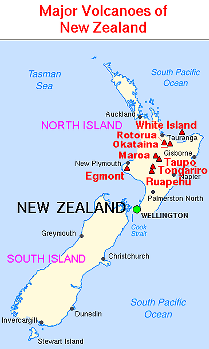
- It is the top of a submarine vent at the northern end of the Taupō-Rotorua Volcanic Zone. With a total land area of about 1,000 acres, it rises to 1,053 feet at Mount Gisborne. Scrub vegetation is common on much of the island.
- The island was sighted and named by Capt. James Cook in 1769. It has numerous hot springs, geysers, and fumaroles, its last eruption, which took place in December 2019.
- Whakaari/White Island is in the Bay of Plenty, 43 miles west of Cape Runaway, eastern North Island, New Zealand is an active volcano.
- Ruapehu:
- Mount Ruapehu is 2800m stratovolcano in New Zealand's central North Island.
- It is also capped by a hydrothermal system and a warm crater lake (Te Wai a Moe).
- The volcano is forested below its line of permanent snow cover. Above the line, glaciers flow from the peak. Within the crater lies a lake, which is drained by the Whangaehu River.
- The temperature and level of its lake is known to vary in cycles, responding to changes in gas released into its base, local weather or the occasional formation of a gas seal.
- The lake is so large it hides the surface activity that is useful for diagnosing volcanoes like Whakaari.
What is a Volcano?
- A volcano is an opening on the surface of a planet or moon that allows material warmer than its surroundings to escape from its interior.
- When this material escapes, it causes an eruption. An eruption can be explosive, sending material high into the sky. Or it can be calmer, with gentle flows of material.
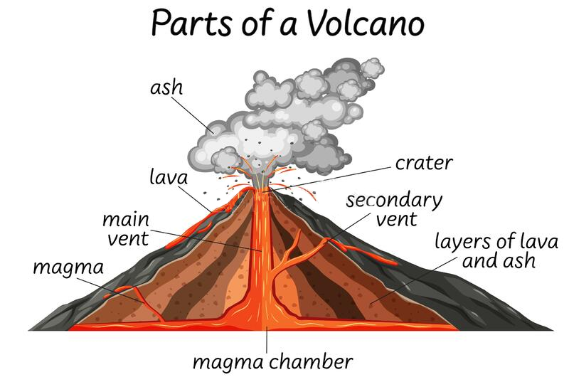
- On Earth, the erupted material can be liquid rock ("lava" when it's on the surface, "magma" when it's underground), ash, cinders, and/or gas.
- There are three reasons why magma might rise and cause eruptions onto Earth’s surface
- Magma can rise when pieces of Earth's crust called tectonic plates slowly move away from each other. The magma rises to fill in the space. When this happens, underwater volcanoes can form.
- Magma also rises when these tectonic plates move toward each other. When this happens, part of Earth's crust can be forced deep into its interior. The high heat and pressure cause the crust to melt and rise as magma.
- The final way that magma rises is over hot spots. Hot spots are the hot areas inside of Earth. These areas heat up magma. The magma becomes less dense. When it is less dense it rises. Each of the reasons for rising magma are a bit different, but each can form volcanoes.
UPSC Civil Services Examination, Previous Year Questions (PYQs)
Q. Consider the following statements: (2018)
- The Barren Island volcano is an active volcano located in the Indian territory.
- Barren Island lies about 140 km east of Great Nicobar.
- The last time the Barren Island volcano erupted was in 1991 and it has remained inactive since then.
Which of the statements given above is/are correct?
(a) 1 only
(b) 2 and 3
(c) 3 only
(d) 1 and 3
Ans: (a)
- Barren Island is India’s only active volcano which is located in the Andaman and Nicobar Islands. Hence, statement 1 is correct.
- It is located at about 140 km from Port Blair, southern part of Andaman Island in Andaman Sea. The distance between Barren Island to Great Nicobar is more than the given distance. Hence, statement 2 is not correct.
- First recorded eruption of the volcano dates back to 1787. In the past 100 years, it has erupted at least five times. Then for the next 100 years, it remained silent. It re-erupted massively in 1991. Since then, the eruption has been recorded every two-three years the latest in the series was February 2016. Hence, statement 3 is not correct.