Landslide Atlas of India | 11 Mar 2023
Prelims: Landslide, Kedarnath disaster in 2013, Land Subsidence and Joshi math Case, Rainfall variability, Western Ghats, Himalayas.
Mains: Key Highlights of Landslide Atlas of India, India’s Vulnerability to Landslides.
Why in News?
Recently, National Remote Sensing Centre (NRSC) under the Indian Space Research Organisation (ISRO) has released the Landslide Atlas of India, a detailed guide identifying Landslide Hotspots in the country.
- NRSC has the mandate for remote sensing satellite data acquisition, processing, archiving, and dissemination to various users.
How was the Atlas Prepared?
- For the first time, scientists did a risk assessment on the basis of 80,000 landslides recorded between 1998 and 2022 in 147 districts in 17 states and two Union Territories to build a "Landslide Atlas" of the country.
- The atlas used satellite data of ISRO to map all seasonal and event-based landslides like the Kedarnath disaster in 2013 and landslides triggered due to the Sikkim earthquake in 2011.
- The pan-India landslide database classifies landslides into – seasonal (2014, 2017 monsoon seasons), event-based and route-based (2000 – 2017).

What are the Key Highlights?
- Uttarakhand, Kerala, Jammu and Kashmir, Mizoram, Tripura, Nagaland and Arunachal Pradesh reported the highest number of landslides during 1998 – 2022.
- Mizoram topped the list, recording 12,385 landslide events in the past 25 years, of which 8,926 were recorded in 2017 alone.
- Mizoram is followed by Uttarakhand (11,219) and Kerala.
- Uttarakhand’s fragility was recently exposed during the land subsidence events reported from Joshimath.
- The number of districts with the maximum landslide exposure are in Arunachal Pradesh (16), Kerala (14), Uttarakhand and Jammu and Kashmir (13 each), Himachal Pradesh, Assam and Maharashtra (11 each), Mizoram (8) and Nagaland (7).
- Rudraprayag and Tehri Garhwal districts of Uttarakhand have the highest landslide density and landslide risk exposure in the country.
How Vulnerable India is to Landslides?
- India is considered among the top five landslide-prone countries globally, where at least one death per 100 sq km is reported in a year due to a landslide event.
- Rainfall variability pattern is the single biggest cause for landslides in the country, with the Himalayas and the Western Ghats remaining highly vulnerable.
- Excluding snow covered areas, approximately 12.6 % of the country’s geographical land area is prone to landslides. As many as 66.5 % of the landslides are reported from the North-western Himalayas, about 18.8 % from the North-eastern Himalayas, and about 14.7 % from the Western Ghats.
- In the Western Ghats, despite fewer events, landslides were found to be making inhabitants significantly vulnerable to fatalities, especially in Kerala.
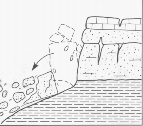
What causes landslides?
- About:
- Landslides are natural disasters occurring mainly in mountainous terrains where there are conducive conditions of soil, rock, geology and slope.
- A sudden movement of rock, boulders, earth or debris down a slope is termed a landslide.
- Causes:
- Natural causes that trigger it include heavy rainfall, earthquakes, snow melting and undercutting of slopes due to flooding.
- They can also be caused by anthropogenic activities such as excavation, cutting of hills and trees, excessive infrastructure development, and overgrazing by cattle.
- Some of the main factors that influence landslides are lithology, geological structures like faults, hill slopes, drainage, geomorphology, land use and land cover, soil texture and depth, and weathering of rocks.
- All these are factored in when a landslide susceptibility zone is earmarked for planning and making predictions.