Kosi River Avulsions | 02 Jun 2022
For Prelims: Kosi River System, Avulsions, Climate Change, Brahmaputra River
For Mains: Causes & Consequences of River Avulsions and the Way Forward
Why in News?
Recently a research study reported that instability in Kosi River has been observed after the construction of embankments on either side of it.
What are Avulsions?
- About:
- Avulsion refers to the phenomenon of change in the course of river flow causing the abandonment of the old established river channel and formation of a new channel.
- Occurrence:
- Rivers lining tropical and desert regions are more prone to avulsions.
- Avulsions occur less frequently, only once a decade or century, or even less.
- The rare occurrence of avulsions makes them less discussed despite their catastrophic effects as compared to more frequent extreme weather events and the continuous effect of sea-level rise.
What are the Key Findings of the Research Study?
- Global Scenario:
- 113 avulsions have been documented worldwide as per the satellite imagery from 1973-2020 and historical maps.
- Rivers altered routes in the mountain bases while descending onto unconfined valleys or open oceans in 33 instances.
- Kosi river falls under this category.
- The change can also occur in the delta regions. One is along backwater zones, part of the river that flows differently because of the effects of the downstream sea.
- Along some of the world’s largest waterways, such as the Orinoco, Yellow, Nile and Mississippi Rivers, 50 instances occurred on low sloping deltas.
- In 30 instances, avulsions occurred in rivers with extreme sediment load. River beds are filled-up with the sediments causing the rivers to seek new channels during floods.
- Case-study of Kosi River:
- Kosi-like systems bring a lot of sediments from the Himalayas. After embankments were made on either side of the river in the 1950s, it became much more unstable.
- In 2008, a large flood forced the Kosi River to leave its established channel for an older one. As a result, 3 million people were displaced and more than 250 human lives were claimed.
- Kosi river avulsions are not at all natural. The 200 km stretch where the river used to distribute sediments before the embankment-construction has now been reduced to 10 km.
- Though the course of sediment-flow has not altered, the area available for its movement has contracted.
- Only a false perception of protection is created due to temporary solutions like embankments. Instead, these aggravate system-scale degradation by limiting natural sediment dispersal.
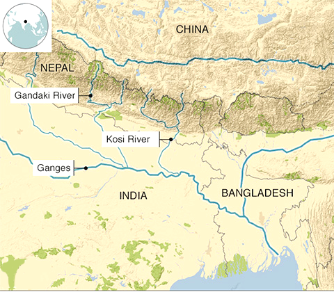
What is the Kosi River System?
- The Kosi is a trans-boundary river which flows through Tibet, Nepal and India.
- It has its source in Tibet that includes the world's highest upland, it then drains a large part of Nepal before emerging onto the Gangetic plains.
- Its three major tributaries, the Sun Kosi, Arun and Tamur meet at one point just upstream of a 10 km gorge cut through the Himalayan foothills.
- The river crosses into northern Bihar, India where it branches into distributaries before joining the Ganges near Kursela in Katihar district.
- The Kosi carries the maximum amount of silt and sand after the Brahmaputra in India.
- It is also known as the “Sorrow of Bihar” as the annual floods affect about 21,000 sq. km. of fertile agricultural lands thereby disturbing the rural economy.
Way Forward
- Approximately 330 million people reside on river deltas worldwide, and even more live along river corridors. Hence, it is high time to understand how climate change and anthropogenic interference is affecting river mobility.
- A complete global picture must be captured to understand the correlation between climate change and river avulsions. The course of river jump in delta regions can be altered by climate change, such as, avulsions can be pushed farther inland in the backwater zone on account of rising sea levels.
- The role of embankments/barriers that are created along rivers for protection against floods must be understood with regards to avulsion-trigger.
- Various engineering interventions can be employed to create additional channels for rivers. This will prevent floods and avulsions by distributing the flow of the water and sediments across channels.
UPSC Civil Services Examination, Previous Year Question
Q. Which of the following is/are tributary/tributaries of Brahmaputra? (2016)
- Dibang
- Kameng
- Lohit
Select the correct answer using the code given below:
(a) 1 only
(b) 2 and 3 only
(c) 1 and 3 only
(d) 1, 2 and 3
Ans: (d)
Exp:
- Brahmaputra basin spreads over the countries of Tibet (China), Bhutan, India and Bangladesh. In India, it spreads over the states of Arunachal Pradesh, Assam, West Bengal, Meghalaya, Nagaland and Sikkim.
- The Brahmaputra River originates in the north from Kailash ranges of the Himalayas at an elevation of 5,150 m just south of the lake Konggyu Tsho and flows for about a total length of 2,900 km. It enters India at Namcha Barwa (Arunachal Pradesh) and flows for 916 km.
- The principal tributaries of the river joining from the right are Kameng, Subansiri, Manas, Sankosh and Teesta, whereas Lohit, Dibang, Burhi Dihing, Desang, Dikhow, Dhansiri join it from the left. Hence, 1, 2 and 3 are correct.
- Therefore, option (d) is the correct answer.