Eastern Rajasthan Canal Project | 19 Mar 2021
Why in News
The Chief Minister of Rajasthan has demanded the national project status for the Eastern Rajasthan Canal Project (ERCP).
- The main advantage of a project which has received national project status is that 90% of the funding for the project will be given by the central government.
- The estimated cost of the ERCP is around Rs. 40,000 crore.
Key Points
- Background:
- According to the state Water Resources Department, Rajasthan, the largest state of India with a geographical area of 342.52 lakh hectares which amount to 10.4% of the entire country, holds only 1.16% of India’s surface water and 1.72% of groundwater.
- Among the state’s water bodies, only the Chambal river basin has surplus water but this water cannot be tapped directly because the area around the Kota barrage is designated as a crocodile sanctuary.
- Through the help of diversion structures, interbasin water transfers, linking channels and construction of pumping main feeder channels, the ERCP aims to create a network of water channels which will cover 23.67 % area of Rajasthan along with 41.13 % population of the state.
- About the Eastern Rajasthan Canal Project:
- It aims to harvest surplus water available during rainy season in rivers in Southern Rajasthan such as Chambal and its tributaries, including Kunnu, Parvati, Kalisindh, and use this water in south-eastern districts of the state, where there is scarcity of water for drinking and irrigation.
- ERCP is planned to meet drinking and industrial water needs of the southern and south eastern Rajasthan, for humans and Livestock till the year 2051.
- It proposes to provide drinking water to 13 districts of Rajasthan and provide irrigation water for 2.8 lakh hectares of land through 26 different large and medium projects.
- 13 districts: Jhalawar, Baran, Kota, Bundi, Sawai Madhopur, Ajmer, Tonk, Jaipur, Karauli, Alwar, Bharatpur, Dausa and Dholpur.
- Benefits:
- A significant area of land will get irrigation facilities.
- It intends to improve the ground water table in the rural areas of the state.
- Positively influencing the socio-economic conditions of the people.
- It adds special emphasis on the Delhi Mumbai Industrial Corridor (DMIC) and envisages that sustainable water sources will enhance and help industries grow in these areas.
- Resulting in investment and revenue.
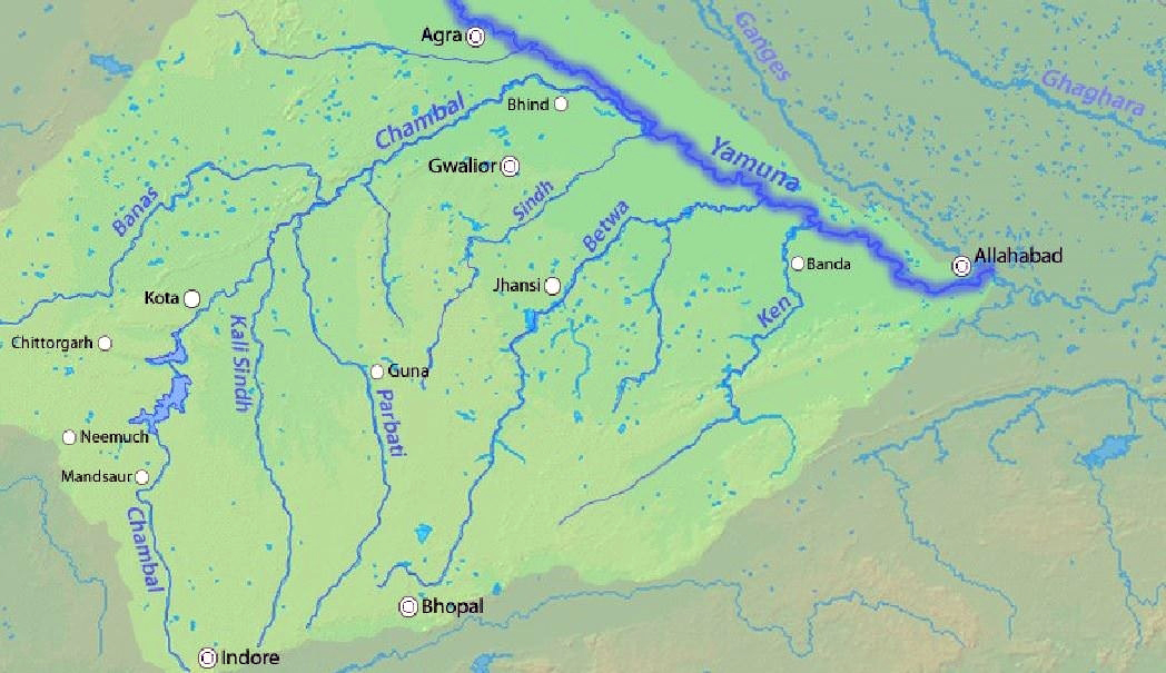
Chambal River
- It is one of the most pollution-free rivers of India.
- It originates at the Singar Chouri peak in the northern slopes of the Vindhya mountains (Indore, Madhya Pradesh). From there, it flows in the North direction in Madhya Pradesh for a length of about 346 km and then follows a north-easterly direction for a length of 225 km through Rajasthan.
- It enters U.P. and flows for about 32 km before joining the Yamuna River in Etawah District.
- It is a rainfed river and its basin is bounded by the Vindhyan mountain ranges and the Aravallis. The Chambal and its tributaries drain the Malwa region of northwestern Madhya Pradesh.
- The Hadauti plateau in Rajasthan occurs in the upper catchment of the Chambal River to the southeast of the Mewar Plains.
- Tributaries: Banas, Kali Sindh, Sipra, Parbati, etc.
- Main Power Projects/ Dam: Gandhi Sagar Dam, Rana Pratap Sagar Dam, Jawahar Sagar Dam, and Kota Barrage.
- The National Chambal Sanctuary is located along river Chambal on the tri-junction of Rajasthan, Madhya Pradesh and Uttar Pradesh. It is known for critically endangered gharial, the red-crowned roof turtle, and the endangered Ganges river dolphin.