Tectonic Plates | 01 Feb 2021
Tectonic Plates
- A tectonic plate (also called lithospheric plate) is a massive, irregularly-shaped slab of solid rock, generally composed of both continental and oceanic lithosphere.
- The lithosphere includes the crust and top mantle with its thickness range varying between 5-100 km in oceanic parts and about 200 km in the continental areas.
- The concept of Tectonic Plates was first introduced in 1967.
- A tectonic plate may be a continental plate or an oceanic plate, depending on which of the two occupies the larger portion of the plate.
- The Pacific plate is largely an oceanic plate whereas the Eurasian plate is a continental plate.
The Major and Minor Plates
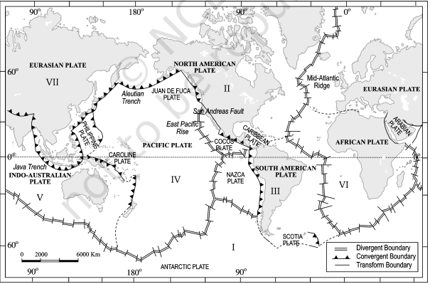
The Earth’s lithosphere is divided into seven major and some minor plates.
- Young Fold Mountain ridges, oceanic trenches, and/or transform faults surround the major plates. These include:
- The Antarctic (and the surrounding oceanic) plate
- The North American plate (with western Atlantic floor separated from the South American plate along the Caribbean islands)
- The South American plate (with western Atlantic floor separated from the North American plate along the Caribbean islands)
- The Pacific plate
- The India-Australia-New Zealand plate
- The Africa with the eastern Atlantic floor plate
- Eurasia and the adjacent oceanic plate
- Some important minor plates include:
- Cocos plate: Between Central America and Pacific plate
- Nazca plate: Between South America and Pacific plate
- Arabian plate: Mostly the Saudi Arabian landmass
- Philippine plate: Between the Asiatic and Pacific plate
- Caroline plate: Between the Philippine and Indian plate (North of New Guinea)
- Fuji plate: North-east of Australia
- Juan De Fuca plate: South-East of North American Plate
- Mountain Ridge: A mountain ridge refers to the chain of mountains or hills that form a continuous elevated crest for some distance.
- Ocean trenches are long, narrow depressions on the seafloor.
- These are the deepest parts of the ocean and some of the deepest natural spots on Earth.
- They are found in every ocean basin on the planet and the deepest ocean trenches ring the Pacific called the “Ring of Fire''.
- A transform fault, in geology and oceanography is a type of fault in which two tectonic plates slide past one another.
The Indian Plate:
- The Indian plate includes Peninsular India and the Australian continental portions.
- In the east, it extends through Rakim Yoma Mountains of Myanmar towards the island arc along the Java Trench.
- The Western margin follows Kirthar Mountain of Pakistan.
- It further extends along the Makrana coast of Balochistan and joins the spreading site from the Red Sea rift southeastward along the Chagos Archipelago.
- The boundary between India and the Antarctic plate is also marked by an oceanic ridge (divergent boundary) running in roughly West to East direction and merging into the spreading site, a little south of New Zealand.
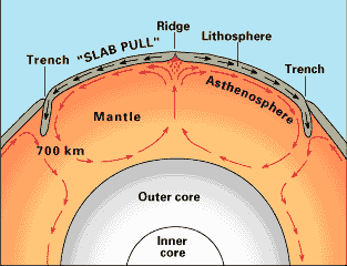
Asthenosphere:
- It is the zone of Earth’s mantle that lies just beneath the lithosphere and is believed to be much hotter and more fluid than the lithosphere.
- The asthenosphere extends from about 100 km (60 miles) to about 700 km (450 miles) below Earth’s surface.
Movement of Plates
The tectonic plates are not fixed but constantly move horizontally over the Asthenosphere as rigid units.
- Sometimes these plates collide, move apart, or slide next to each other which leads to Earthquakes or Volcanic Eruptions.
- Rates of Movement of Tectonic Plates: The rates of movement of the tectonic plates vary considerably.
- The Arctic Ridge has the slowest rate (less than 2.5 cm/yr), and the East Pacific Rise, in the South Pacific (about 3,400 km west of Chile) has the fastest rate (more than 15 cm/yr).
- Force for the Movement of Tectonic Plates: The mobile rock beneath the rigid plates is believed to be moving in a circular manner.
- The heated material rises to the surface, spreads and begins to cool, and then sinks back into deeper depths.
- This slow movement of hot, softened mantle that lies below these rigid plates is the driving force behind the plate movement.
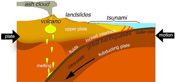
Subduction
- It happens when tectonic plates shift, and one plate is pushed under another.
- This movement of the ocean floor produces a "mineral transmutation", which leads to the melting and solidification of magma i.e., the formation of volcanoes.
- In other words, when a "downgoing" oceanic plate is pushed into a hotter mantle plate, it heats up, volatile elements mix, and this produces the magma.
- The magma then rises up through the overlying plate and spurts out at the surface.
Boundaries of Plates
The movement of the tectonic plates creates three types of tectonic boundaries:
- Convergent, where plates move into one another.
- Divergent, where plates move apart.
- Transform, where plates move sideways in relation to each other.
Convergent Boundaries
- A convergent plate boundary is formed when tectonic plates crash into each other. They are also known as destructive boundaries.
- These boundaries are often subduction zones, where the heavier plate slips under the lighter plate, creating a deep trench.
- This subduction changes the dense mantle material into buoyant magma, which rises through the crust to the Earth’s surface.
- Over millions of years, the rising magma has been creating a series of active volcanoes known as a volcanic arc.
- Other than Subduction Zones, convergent plate boundaries also lead to mountain building and the formation of island arcs (Festoons).
- If both the convergent plates are oceanic, the volcanoes form a curved line of islands, known as an island arc, that is parallel to the trench.
- There are three ways in which convergence can occur:
- between an oceanic and continental plate
- between two oceanic plate
- between two continental plates.
- When continental and oceanic plates collide, the thinner and more dense oceanic plate is overridden by the thicker and less dense continental plate.
- Examples:
- The Washington-Oregon coastline of the United States is an example of oceanic-continental convergent plate boundary.
- Here, the Juan de Fuca oceanic plate is subducted beneath the North American continental plate.
- An example of the oceanic-oceanic convergence is the Mariana Trench, the deepest point on Earth.
- The mighty Pacific plate subducts beneath the smaller, less-dense Philippine plate.
- The Himalayan Mountain Range is the best active example of continental convergent plate boundaries.
- India and Asia crashed about 55 million years ago, slowly giving rise to the Himalayas, the highest mountain system on Earth.
- Here, the Indian and Eurasian plates are currently in collision.
- The Washington-Oregon coastline of the United States is an example of oceanic-continental convergent plate boundary.
Subduction Zones
- A subduction zone is the biggest crash scene on Earth. These boundaries mark the collision between two tectonic plates.
- When two tectonic plates meet at a subduction zone, one bends and slides underneath the other, curving down into the mantle, the hotter layer under the crust.
Divergent Boundaries
- A divergent boundary is formed by tectonic plates pulling apart from each other. They are known as constructive boundaries.
- Divergent boundaries are the site of seafloor spreading and rift valleys.
- At divergent boundaries in the oceans, magma from deep in the Earth's mantle rises toward the surface and pushes apart two or more plates. Mountains and volcanoes rise along the seam. The process renews the ocean floor and widens the giant basins.
- The best-known example of divergent boundaries is the Mid-Atlantic Ridge where the American Plates are separated from the Eurasian and African Plates.
- This single mid-ocean ridge system connects the world's oceans, making the ridge the longest mountain range in the world (10,000 miles).
- The best-known example of divergent boundaries is the Mid-Atlantic Ridge where the American Plates are separated from the Eurasian and African Plates.
- On land, giant troughs such as the Great Rift Valley in Africa form where plates are tugged apart.
- If the plates there continue to diverge, millions of years from now eastern Africa will split from the continent to form a new landmass.
- A mid-ocean ridge would then mark the boundary between the plates.
Seafloor Spreading
- Seafloor spreading is the process of magma welling up in the rift as the old crust pulls itself in opposite directions.
- Cold seawater cools the magma, creating a new crust.
- The upward movement and eventual cooling of this magma has created high ridges on the ocean floor over millions of years.
- The East Pacific Rise is a site of major seafloor spreading in the Ring of Fire.
- It is located on the divergent boundary of the Pacific Plate, the Cocos Plate (west of Central America), the Nazca Plate (west of South America), the North-American Plate and the Antarctic Plate.
Rift Valleys
- A rift valley is a lowland region that forms where Earth’s tectonic plates move apart, or rift.
- Rift valleys are found both on land and at the bottom of the ocean and are created by the process of seafloor spreading.
- Rift valleys differ from river valleys and glacial valleys in that they are created by tectonic activity and not the process of erosion.
- The Great Rift Valley System which stretches from the Middle East in the north to Mozambique in the south is a geologically active area.
- It features volcanoes, hot springs, geysers, and frequent earthquakes.
Transform Boundaries
- A transform boundary is formed as tectonic plates slide horizontally past each other but parts of these plates get stuck at the places where they touch.
- These boundaries are conservative because plate interaction occurs without creating or destroying crust.
- Hence, they don't produce spectacular features like mountains or oceans, but the halting motion often triggers large earthquakes, such as the 1906 earthquake that devastated San Francisco.
- These boundaries are conservative because plate interaction occurs without creating or destroying crust.
- In these areas of contact, stress is built which causes the rocks to break or slip, suddenly lurching the plates forward and causing earthquakes.
- These areas of breakage or slippage are called faults. The majority of Earth’s faults can be found along transform boundariesin the Ring of Fire.
- The San Andreas Fault in California is an example of a transform boundary, where the Pacific Plate moves northward past the North American Plate.
- It is one of the most active faults on the Ring of Fire.
Hotspots
- Most of the volcanic activities are concentrated along or adjacent to plate boundaries, but there are some important exceptions in which this activity occurs within plates, called the Hotspots.
- Hotspots exist over the Mantle Plumes.
- A mantle plume is an area under the crust of Earth, where magma is hotter than surrounding magma.
- Heat from this extra hot magma causes melting and thinning of the rocky crust, which leads to widespread volcanic activity on Earth’s surface above the plume.
- The hotspots are stationary, unlike the tectonic plates where they are located.
- There are about 40 to 50 hot spots estimated to be around the world.
- Major hot spots include :
- The Iceland hotspot, under the island of Iceland in the North Atlantic.
- The Réunion hot spot, under the island of Réunion in the Indian Ocean.
- The Afar hotspot, located under northeastern Ethiopia.