Pacific Ring of Fire | 08 Feb 2021
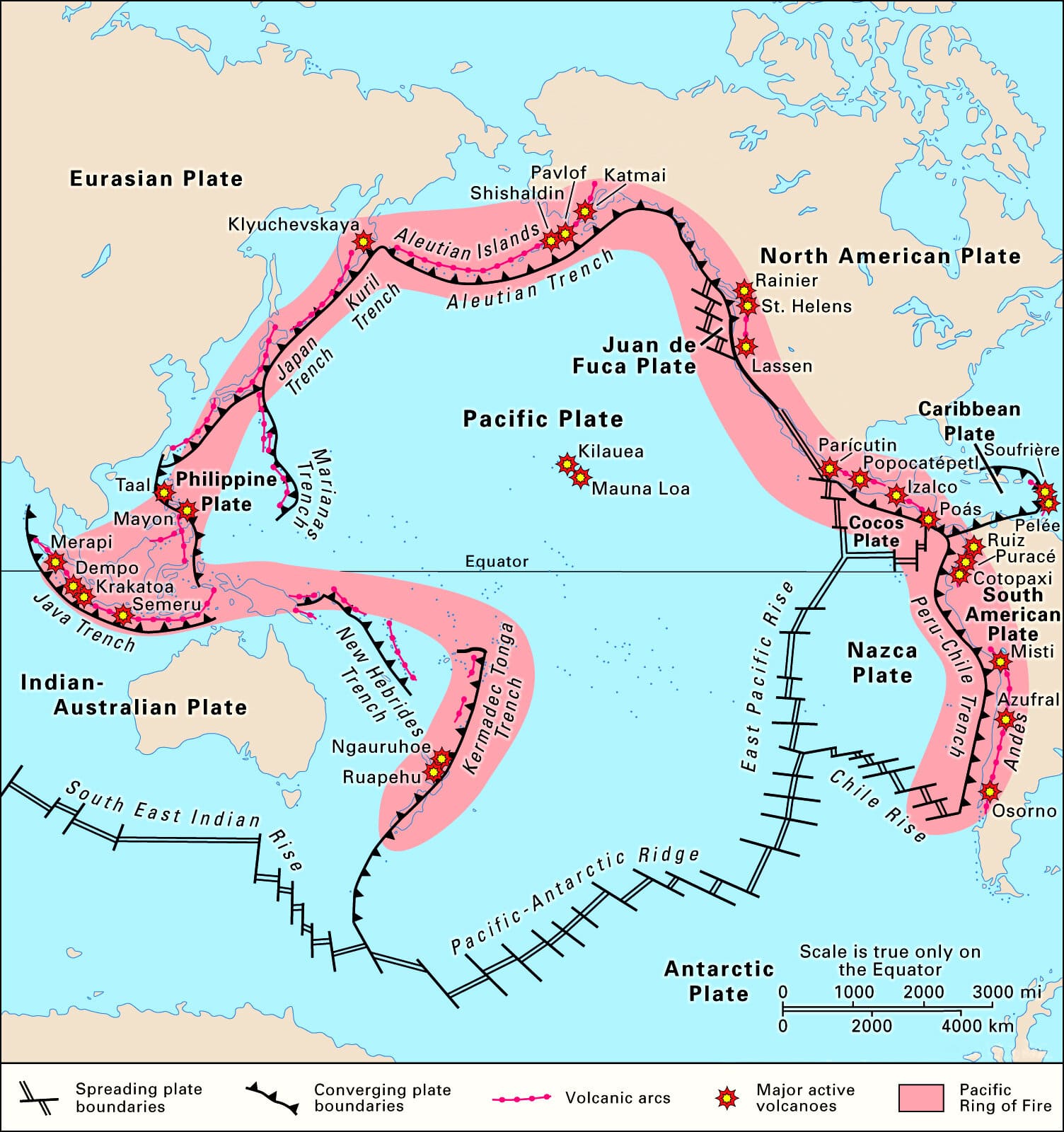
- The Ring of Fire, also referred to as the Circum-Pacific Belt, is a path along the Pacific Ocean characterized by active volcanoes and frequent earthquakes.
- It is largely a result of Plate Tectonics where massive Pacific Plate interacts with less-dense plates surrounding it.
- The majority of Earth’s volcanic eruptions and earthquakes take place along the Ring of Fire.
- The next most seismically active region (5-6% of earthquakes) is the Alpide belt (extends from Mediterranean region, eastward through Turkey, Iran, and northern India.
Geographical Stretch of Ring of Fire
- The Ring of Fire is stretched to approximately 40,000 kilometers (24,900 miles) tracing boundaries between several tectonic plates including the Pacific, Juan de Fuca, Cocos, Indian-Australian, Nazca, North American, and Philippine Plates.
- The chain runs up along the western coast of South and North America, crosses over the Aleutian Islands in Alaska, runs down the eastern coast of Asia past New Zealand and into the northern coast of Antarctica.
- Bolivia, Chile, Ecuador, Peru, Costa Rica, Guatemala, Mexico, United States, Canada, Russia, Japan, Philippines, Australia, Papua New Guinea, Indonesia, New Zealand, and Antarctica are some of the important places located in the ring of the fire.
Features of Ring of Fire
Active volcanoes:
- The Ring of Fire is home to more than 450 active and dormant volcanoes (75% of Earth’s total volcanoes) forming a semicircle or horse shoe around the rim of the Pacific Ocean.
- Most of the active volcanoes on the Ring of Fire are found on its western edge, from Russia to New Zealand.
- Major volcanic events that have occurred within the Ring of Fire since 1800 including the eruptions of Mount Tambora, Indonesia (1815), Mount Ruiz, Columbia (1985), and Mount Pinatubo, Philippines (1991).
- The Mount Tambora of Indonesia, which erupted in 1815 was the largest volcanic eruption in recorded history.
- It is now 2,851 metres (9,354 feet) high after losing much of its top in the 1815 eruption.
- Mount Ruapehu in New Zealand is one of the more active volcanoes in the Ring of Fire, with yearly minor eruptions, and major eruptions occurring about every 50 years.
- Krakatoa, an island volcano, erupts less often than Mount Ruapehu, but much more spectacularly.
- An infamous eruption in 1883 destroyed the entire island, sending volcanic gas, volcanic ash, and rocks as high as 80 kilometers (50 miles) in the air.
- Mount Fuji, Japan’s tallest and most famous mountain, is an active volcano in the Ring of Fire.
- Mount Fuji sits at a “triple junction”, where three tectonic plates (the Amur Plate, Okhotsk Plate, and Philippine Plate) interact.
- The Ring of Fire’s eastern half also has a number of active volcanic areas, including the Aleutian Islands, the Cascade Mountains in the western U.S., the Trans-Mexican Volcanic Belt, and the Andes Mountains.
- Mount St. Helens, in the U.S. state of Washington, is an active volcano in the Cascade Mountain.
- It lies on a particularly weak section of crust, which makes it more prone to eruptions. Its historic 1980 eruption lasted 9 hours and covered nearby areas in tons of volcanic ash.
- Popocatépetl is one of the most dangerous volcanoes in the Ring of Fire.
- The mountain is one of Mexico’s most active volcanoes, with 15 recorded eruptions since 1519.
Earthquakes
- 90% of earthquakes occur along its path, including the planet’s most violent and dramatic seismic events.
- The Ring of Fire has been the setting for the most devastating earthquakes in recorded history, including the Chile earthquake of 1960 and 2010, the Alaska earthquake of 1964, and the Japan earthquake of 2011 as well as the earthquake that produced the devastating Indian Ocean tsunami of 2004.
- The Valdivia Earthquake of Chile, occurred in 1960, was the strongest recorded earthquake at 9.5 out of 10 on the Richter scale.
- The Chile Earthquake is closely followed by the Great Alaska Earthquake, 1964 (magnitude 9.2)
- The Northern Sumatra earthquake (the Indian Ocean Tsunami), December 26, 2004 (magnitude 9.1)
- The Earthquake on the East Coast of Honshu, Japan on March 11, 2011 (magnitude 9.0) which led to a tsunami and ultimately the nuclear disaster at Fukushima.
Island Arcs
- They are long, curved chains of oceanic islands associated with intense volcanic and seismic activity and orogenic (mountain-building) processes.
- An island arc typically has a land mass or a partially enclosed, unusually shallow sea on its concave side.
- Along the convex side there almost invariably exists a long, narrow deep-sea trench.
- The greatest ocean depths are found in these depressions of the seafloor, as in the case of the Mariana (deepest trench in the world) and Tonga trenches.
- Prime examples of this form of geologic feature include the Aleutian-Alaska Arc and the Kuril-Kamchatka Arc.
Trenches
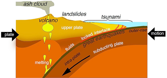
- Ocean trenches are steep depressions in the deepest parts of the ocean where an old ocean crust from one tectonic plate is pushed beneath another plate, raising mountains, causing earthquakes, and forming volcanoes on the seafloor and on land.
- The ring of fire is home to the deepest ocean trench, called the Mariana Trench. It is a 7-mile-deep trench.
- Other trenches in the region are: Philippine Trench, Challenger trench, Kuril- Kamchatka Trench, Peru–Chile Trench and Tonga Trench.
- The presence of oceanic trenches indicates tectonic instability extending into the mantle of the earth.
- The trench is probably the oldest part of the structure, is the seat of normal-depth earthquake.
Cause of Frequent Earthquakes and Volcanism
- The Ring of Fire is the result of tectonic plates which are huge slabs of the Earth’s crust, fitting together like pieces of a puzzle.
- Sometimes these moving plates collide, or move apart, or slide next to each other, which lead to the formation of convergent, divergent or transform boundaries (respectively).
- This constant collision, diversion or sliding-past-each-other movement of tectonic plates results in deep ocean trenches, volcanic eruptions, and earthquake epicenters along the boundaries where the plates meet, called fault lines.
- Volcanoes are created through the process of subduction and most of the planet's subduction zones happen to be located in the Ring of Fire.
- A significant exception is the border between the Pacific and North American Plates.
- This stretch of the Ring of Fire is a transform boundary, where plates move sideways past one another.
- This type of boundary generates a large number of earthquakes as tension in Earth’s crust builds up and is released.
Subduction:
- Subduction happens when tectonic plates shift, and one plate is pushed under another. This movement of the ocean floor produces a "mineral transmutation", which leads to the melting and solidification of magma i.e., the formation of volcanoes.
- In other words, when a "downgoing" oceanic plate is pushed into a hotter mantle plate, it heats up, volatile elements mix, and this produces the magma. The magma then rises up through the overlying plate and spurts out at the surface.
- A subduction zone is the biggest crash scene on Earth. These boundaries mark the collision between two tectonic plates.
- When two tectonic plates meet at a subduction zone, one bends and slides underneath the other, curving down into the mantle, the hotter layer under the crust.
Source of Geothermal Resources
- World’s largest geothermal energy resources (more than 40%) are stored in the Pacific Ring of Fire.
- Geothermal resources are highly associated with the active plate boundary (divergent or convergent plate type) where volcanism or frequent earthquakes have occurred.
- The region is tectonically a very much active region, and as a result, it has stored a lot of heat which can be used as geothermal resources.
- Around 13 GW (till 2015) power generations had been installed on the basis of geothermal resources in the world where more than 6 GW have been found in the ring of fire region.
- The geothermal energy resources can be utilized both for electricity generation and direct uses.
- Roughly estimated more than 110 GW electricity generation capabilities of geothermal resources can be found in this region.
Recent Research
- The Pacific Plate, which drives much of the tectonic activity in the Ring of Fire, is cooling off.
- Scientists have discovered that the youngest parts of the Pacific Plate (about 2 million years old) are cooling off and contracting at a faster rate than older parts of the plate (about 100 million years old).
- The younger parts of the plate are found in its northern and western parts; the most active parts of the Ring of Fire.