Landforms of the Earth | 05 May 2022
What are Landforms?
- A landform is a feature on the Earth's surface that is part of the terrain.
- Each landform has its own physical shape, size, materials and is a result of the action of certain geomorphic processes and agent(s).
- Actions of most of the geomorphic processes and agents are slow, and hence the results take a long time to take shape.
- Every landform has a beginning and landforms once formed may change in their shape, size and nature slowly or fast due to continued action of geomorphic processes and agents.
What are the Landforms Made by Running Water?
- In humid regions, which receive heavy rainfall, running water is considered the most important of the geomorphic agents in bringing about the degradation of the land surface.
- Most of the erosional landforms made by running water are associated with vigorous and youthful rivers flowing over steep gradients.
- Erosional Landforms by Running Water:
- Valleys:
- Valleys start as small and narrow rills and the rills will gradually develop into long and wide gullies; the gullies will further deepen, widen and lengthen to give rise to valleys.
- Types of Valleys:
- Gorge:
- A gorge is a deep valley with very steep to straight sides.
- A gorge is almost equal in width at its top as well as its bottom.
- Gorges form in hard rocks.

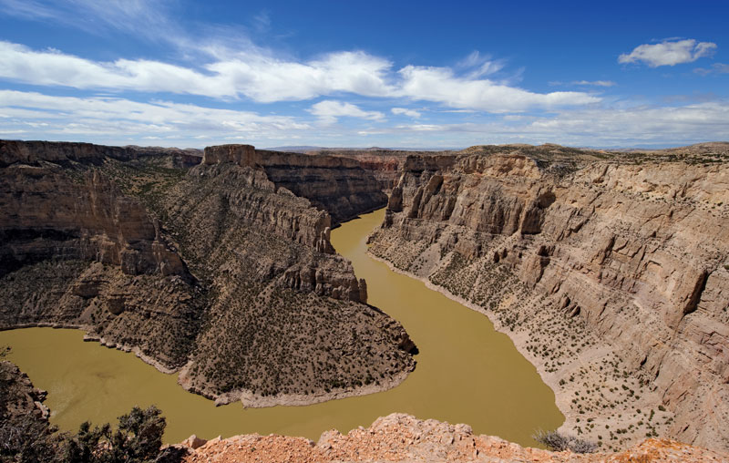
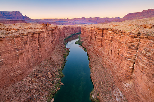
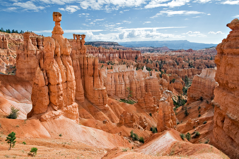
- Canyon:
- A canyon is characterised by steep step-like side slopes and may be as deep as a gorge.
- A canyon is wider at its top than at its bottom. In fact, a canyon is a variant of a gorge.
- Canyons commonly form in horizontal bedded sediment.
- Gorge:
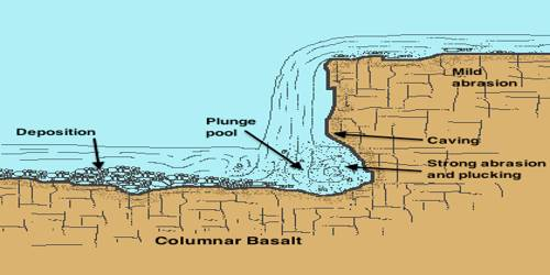
- Potholes and Plunge Pools:
- Potholes are more or less circular depressions formed because of stream erosion aided by the abrasion of rock fragments.
- Once a small and shallow depression forms, pebbles and boulders get collected in those depressions and get rotated by flowing water and consequently the depressions grow in dimensions.
- Plunge pools are large potholes, quite deep and wide, formed because of the sheer impact of water and rotation of boulders.
- These pools also help in the deepening of valleys.
- These pools also help in the deepening of valleys.
- Potholes are more or less circular depressions formed because of stream erosion aided by the abrasion of rock fragments.
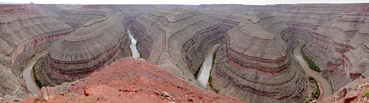
- Incised or Entrenched Meanders:
- Incised or Entrenched Meanders are very deep and wide meanders that can be found cut in hard rocks.
- Entrenched meander normally occurs where there is a rapid cutting of the river bed such that the river does not erode the lateral sides.
- Because of active lateral erosion, streams flowing over gentle slopes develop sinuous or meandering courses.
- It is common to find meandering courses over floodplains and delta plains where stream gradients are very gentle.

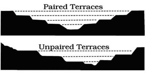
- River Terraces:
- River terraces are surfaces marking old valley floor or floodplain levels.
- They are basically products of erosion as they result due to vertical erosion by the stream into its own depositional floodplain.
- The river terraces may occur at the same elevation on either side of the rivers in which case they are called paired terraces.
- When the terraces are seen only on one side with none on the other or one at quite a different elevation on the other side, they are called unpaired terraces.

- Valleys:
- Depositional Landforms by Running Water
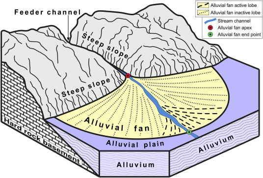
- Alluvial Fans:
- Alluvial fans are formed when streams flowing from higher levels break into foot slope plains of low gradient.
- Normally a very coarse load is carried by streams flowing over mountain slopes.
- This load becomes too heavy for the streams to be carried over gentler gradients and gets dumped and spread as a broad low to high cone shaped deposit called alluvial fan.
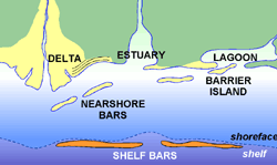
- Deltas:
- Deltas are like alluvial fans but develop at a different location.
- The load carried by the rivers is dumped and spread into the sea.
- If this load is not carried away far into the sea or distributed along the coast, it spreads and accumulates as a low cone.
- Unlike in alluvial fans, the deposits making up deltas are very well sorted with clear stratification.
- Floodplains:
- A floodplain (or floodplain) is a generally flat area of land next to a river or stream.
- It stretches from the banks of the river to the outer edges of the valley.
- A floodplain consists of two parts.
- Foodway:
- The first is the main channel of the river itself, called the floodway.
- Floodways can sometimes be seasonal, meaning the channel is dry for part of the year.
- The first is the main channel of the river itself, called the floodway.
- Flood Fringe:
- Beyond the floodway is the flood fringe. The flood fringe extends from the outer banks of the floodway to the bluff lines of a river valley.
- Foodway:
- A river bed made of river deposits is the active floodplain and the floodplain above the bank is inactive floodplain.
- Inactive floodplains above the banks basically contain two types of deposits — flood deposits and channel deposits.
- In plains, channels shift laterally and change their courses occasionally leaving cut-off courses which get filled up gradually.
- Such areas over flood plains built up by abandoned or cut-of channels contain coarse deposits.
- The flood deposits of spilled waters carry relatively finer materials like silt and clay.
- The floodplains in a delta are called delta plains.
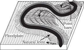
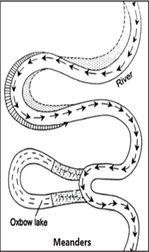
- Meanders:
- Meander is not a landform but is only a type of channel pattern. This is because of:
- Propensity of water flowing over very gentle gradients to work laterally on the banks.
- Unconsolidated nature of alluvial deposits making up the banks with many irregularities which can be used by water exerting pressure laterally.
- Coriolis force acting on the fluid water defecting it like it defects the wind.
- The tendency to meander is reduced, if there is no deposition and no erosion or undercutting.
- An oxbow lake is a meander that is no longer attached to the river.
- The water has to find a straighter route downstream during the floods, so the water flows over the ends of the meander.
- As the flood starts to go down, the water deposits sediment and covers up the ends of the meander making an oxbow lake.
- Meander is not a landform but is only a type of channel pattern. This is because of:
- Alluvial Fans:


What are the Landforms Made by Groundwater?
- Groundwater is a strong erosional force, as it works to dissolve away solid rock.
- Rainwater absorbs carbon dioxide (CO2) as it falls. The CO2 combines with water to form carbonic acid. The slightly acidic water sinks into the ground and moves through pore spaces in soil and cracks and fractures in rock. The flow of water underground is groundwater.
- Carbonic acid is especially good at dissolving the rock limestone.
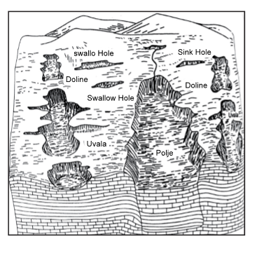
- Any limestone or dolomitic region showing typical landforms produced by the action of groundwater through the processes of solution and deposition is called Karst topography.
- The karst topography is also characterised by erosional and depositional landforms.
- Erosional Landforms by Groundwater:
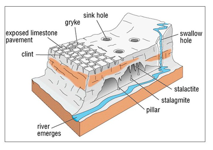
- Swallow Holes, Sinkholes, Lapies and Limestone Pavements:
- Swallow Holes:
- Small to medium sized round to sub-rounded shallow depressions called swallow holes form on the surface of limestones through solution.
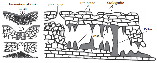
- Sinkholes:
- They are very common in limestone/karst areas.
- A sinkhole is an opening more or less circular at the top and funnel-shaped towards the bottom with sizes varying in area from a few sq. m to a hectare and with depth from a less than half a meter to thirty meters or more.
- Lapies:
- Lapies are uneven grooves and ridges that form when the majority of the limestone's surface is removed by the solution process.
- Deep grooves separate the etched, fluted, and pitted rock pinnacles that make up the weathered limestone surface seen in the karst region.
- Limestone Pavements:
- A limestone pavement is a natural karst landform consisting of a flat, incised surface of exposed limestone that resembles an artificial pavement.
- Swallow Holes:
- Caves:
- In areas where there are alternating beds of rocks (shales, sandstones, quartzites) with limestones or dolomites in between or in areas where limestones are dense, massive and occurring as thick beds, cave formation is prominent.
- There can be a maze of caves at different elevations depending upon the limestone beds and intervening rocks.
- Swallow Holes, Sinkholes, Lapies and Limestone Pavements:
- Depositional Landforms by Groundwater
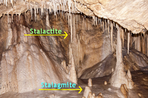
- Stalactites:
- Stalactites hang as icicles of different diameters.
- Normally they are broad at their bases and taper towards the free ends showing up in a variety of forms.
- Stalagmites:
- Stalagmites rise up from the floor of the caves.
- They form due to dripping water from the surface or through the thin pipe of the stalactite, immediately below it.
- Stalagmites may take the shape of a column, a disc, with either a smooth, rounded bulging end or a miniature crater like depression.
- Pillars:
- The stalagmite and stalactites eventually fuse to give rise to columns and pillars of different diameters.
- The stalagmite and stalactites eventually fuse to give rise to columns and pillars of different diameters.
- Stalactites:
| Landform made by Running Water | ||
| Erosional Landforms | ||
| Gorge |
|
 |
| Canyon |
|
 |
| Potholes and Plunge Pools |
|
 |
| Incised or Entrenched Meanders |
|
 |
| River Terraces |
|
 |
| Depositional Landforms | ||
| Alluvial Fans |
|
 |
| Deltas |
|
 |
| Floodplains |
|
 |
| Meanders |
|
 |
| Landform made by Groundwater | ||
| Erosional Landforms | ||
| Swallow Holes |
|
 |
| Sinkholes |
|
|
| Lapies |
|
|
| Limestone Pavements |
|
|
| Caves |
|
|
| Depositional Landforms | ||
| Stalactites |
|
 |
| Stalagmites |
|
|
| Pillars |
|
 |