Cyclone Vayu
The India Meteorological Department issued an orange alert over Cyclone Vayu.
- Cyclone Vayu, named by India, is only a deep depression and is still to develop into a strong cyclone.
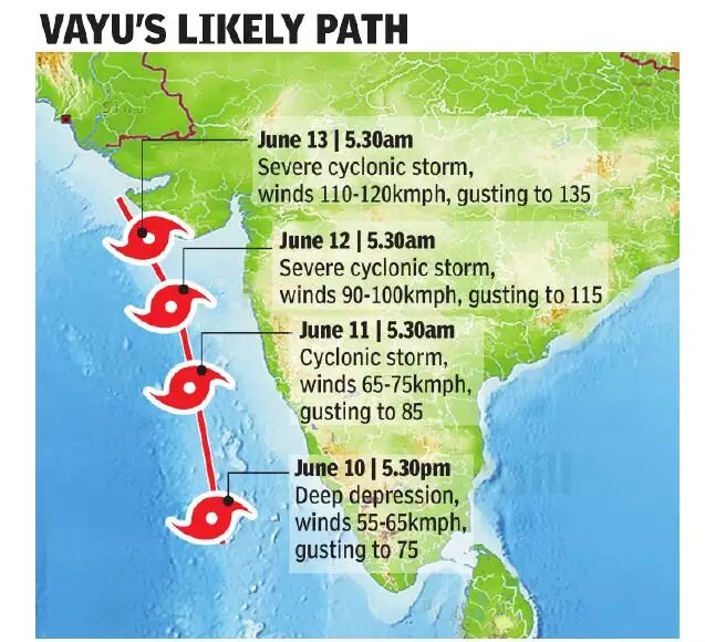
- The cyclone is currently positioned around 250 km northwest of Amindivi island in Lakshadweep and about 750 km southwest of Mumbai in the Arabian sea.
- Cyclone Vayu is moving towards the North (expected to hit Gujarat coast) and is expected to draw moisture away from the monsoon that in turn will delay the arrival of monsoon
- The cyclone is expected to interfere with normal progression, by sucking all the moisture from the monsoon winds towards itself.
- Cyclones are sustained by very strong low-pressure areas at their core. Winds in surrounding areas are forced to rush towards these low-pressure areas.
- Similar low-pressure areas, when they develop near or over land, are instrumental in pulling the monsoon winds over the country as well.
- But right now, the low-pressure area at the center of the cyclone is far more powerful than any local system that can pull the monsoon winds moving northeast.
Different Cyclonic Alerts
- Yellow: Be Updated
- Orange: Be prepared
- Red: Take action
- Green: No warning
Arabian Sea Cyclones
- Cyclonic activity is comparatively less intense in the Arabian sea, as compared to the Bay of Bengal, where high-intensity severe cyclones originate frequently.
- In the last 120 years, just about 14% of all cyclonic storms, and 23% of severe cyclones, around India have occurred in the Arabian Sea.
- Arabian Sea cyclones are also relatively weak compared to those emerging in the Bay of Bengal.
- Gujarat coastline, where most of the cyclones emerging in the Arabian Sea are headed, is not very densely populated, ensures that the damage potential of the cyclones on the western coast is comparatively low.
Why is the Bay of Bengal More Prone to Cyclones?
- Temperature difference: The low-pressure system of cyclone need a continuous supply of heat energy and as the Bay of Bengal is warmer than the Arabian sea, it is able to provide the heat energy needed to sustain the low-pressure system.
- Sea surface temperatures and humidity: both directly correlate with chances of cyclone formation.
- The Bay of Bengal receives higher rainfall and constant inflow of fresh water from the Ganga and Brahmaputra rivers.
- This means that the Bay’s surface water keeps getting refreshed, making it impossible for the warm water to mix with the cooler water below, making it ideal for depression.
- On the other hand, the Arabian Sea receives stronger winds that help dissipate the heat, and the lack of constant fresh water supply helps the warm water mix with the cool water, reducing the temperature.
- Absence of large landmass between the Pacific and the Bay, allows cyclonic winds to easily move into the Bay of Bengal.
- Cyclones from Pacific ocean: low-pressure system originating from the Pacific ocean also travel towards the left to the Bay of Bengal.