Cartosat-3
Why in News
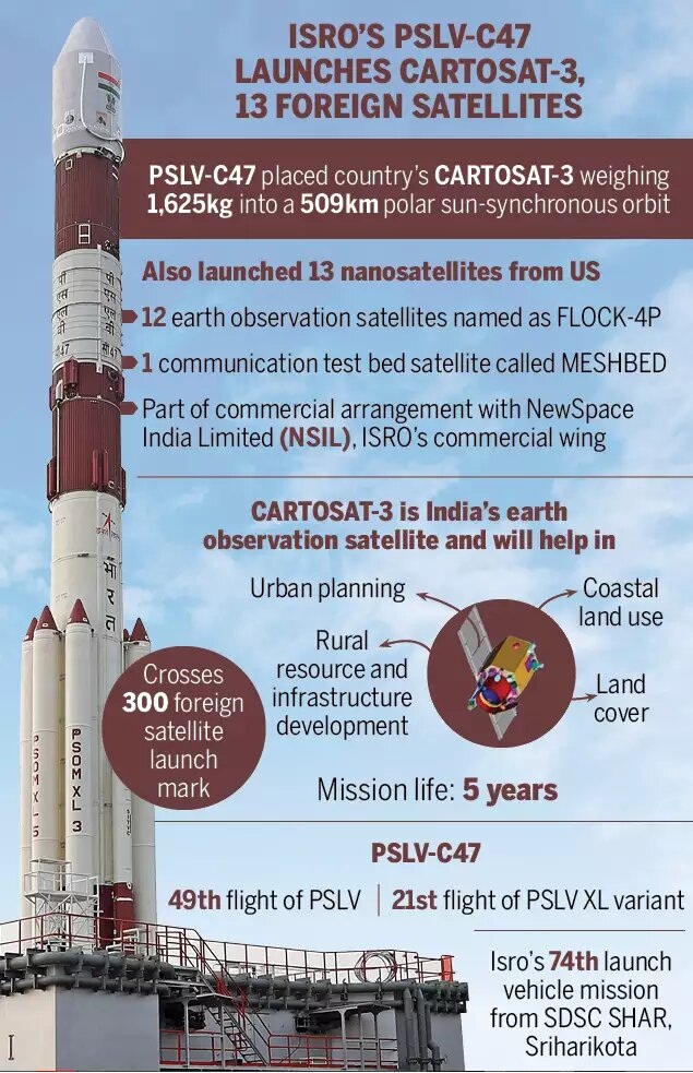
Indian Space Research Organisation (ISRO) has launched Cartosat-3 and 13 commercial nanosatellites into Sun Synchronous orbit from Satish Dhawan Space Centre (SDSC), Sriharikota.
- Cartosat-3 is an earth-observation remote sensing satellite which will replace Indian Remote Sensing (IRS) series. So far, ISRO has orbited 8 Cartosats since 2005.
- Remote sensing is the science of obtaining information about objects or areas from a distance, typically from aircraft or satellites.
- The 13 commercial nanosatellites are from the USA, which is the first commercial order for New Space India Limited, the commercial arm of ISRO which was formed in March 2019.
Key Points
- Cartosat-3 is a third-generation advanced earth observation satellite carried by Polar Satellite Launch Vehicle, PSLV-C47.
- PSLV (Polar Satellite Launch Vehicle) is an indigenously-developed expendable launch system of the ISRO.
- Resolution: It has the 'sharpest eye' of civil remote sensing satellites in the world.
- One of Cartosat-3’s cameras offers a ground resolution of 25 cm - it can pick up an object of a minimum of 25 cm size from a height of around 500 km.
- Currently, a satellite owned by US private company- WorldView-3, has the best ground resolution of 31 cm.
- Weight: At 1,625 kg, Cartosat-3 is unusually heavy and more than double the mass of the previous eight in its class.
- Orbit: PSLV will place Cartosat 3 in an orbit of 509 km.
- Inclination: It has been placed at 97.5 degrees to the equator of the earth.
- It has many new technologies such as a highly agile or flexible camera; high-speed data transmission, advanced computer system, etc.
Applications
- Data from most of the Cartosat satellites are exclusively used by the armed forces.
- However, an existing policy allows only government and government authorised agencies to access ISRO's high-resolution imageries below a resolution of 1 metre.
- Cartosat-3’s optical imaging will also help to detect precise cartographic or mapping activities.
- The imageries are also used for urban and rural infrastructure planning, coastal land use and regulation, utility management such as monitoring road networks, water grids or distribution, creation of land use maps, disaster management, etc.
Cartosat Satellites
- The Cartosat satellites are earth observation satellites, used mainly for large-scale mapping of the Earth through high-resolution cameras.
- It also helps to detect changes in natural geographical or man-made features. As their cameras can `look back and forth' in an angle to generate continuous spot images.
- The Earth-observation satellites also include the Resourcesat and RISAT series, the Oceansat series.
- The Resourcesat and RISAT series of satellites, for example, provide images and data that are needed for land and water resources applications.
- The Oceansat series and the SARAL satellite, meanwhile, produce data on the oceans.
- The satellites like INSAT 3D, INSAT-VRR or Megha Tropiques study the atmosphere.