CHAPTER 4: Distribution of Oceans and Continents (Date : 16-05-2020)
Question 1:
Which of the following statements are correct about Wegener’s Continental Drift.
- All the continents formed a single supercontinent called Pangaea.
- The mega-ocean was called Panthalassa surrounded Pangaea.
- Pangaea broke into two large continental masses as Laurasia and Gondwanaland.
Select the correct answer using the code given below.
1 and 2 only
2 and 3 only
3 only
1, 2 and 3
Correct Answer : D
Explanation
- According to Wegener, all the continents formed a single continental mass and the mega ocean surrounded the same. The super continent was named Pangaea, which meant all earth.
- The mega-ocean was called Panthalassa, meaning all water. He argued that, around 200 million years ago, the supercontinent, Pangaea, began to split. Pangaea first broke into two large continental masses as Laurasia and Gondwanaland forming the northern and southern components respectively. Subsequently, Laurasia and Gondwanaland continued to break into various smaller continents that exist today. Hence, all three statements are correct and option (d) is the correct answer.
The evidence proposed by Alfred Wegner proposed by Alfred Wegener in support of his theory of Continental Drift includes.
- Matching of the continents shoreline (Jig-Saw-Fit)
- Presence of Tillite deposits across continents
- Rocks of Same Age Across the Oceans
- Distribution of fossils
- Placer Deposits presence and absence across continents.
Question 2:
Tillites are:
the sedimentary rock formed out of deposits of glaciers.
the deposits found on continental shelves which are rich in minerals.
The crystalline solid that consists of methane molecules.
The end product of the fluvial cycle.
Correct Answer : A
Explanation
- Tillites are sedimentary rock that consists of consolidated masses of unweathered blocks (large, angular, detached rock bodies) and glacial till (unsorted and unstratified rock material deposited by glacial ice) in a rock flour (matrix or paste of unweathered rock). Hence, option (a) is the correct answer.
Question 3:
Arrange the following ocean relief features in the correct sequence of occurrence from land to ocean basin.
Continental Shelf-Continental Rise-Continental Slope-Abyssal Plain
Abyssal Plain-Continental Shelf-Continental Rise-Continental Slope
Continental Shelf-Abyssal Plain-Continental Slope-Continental Rise
Continental Shelf-Continental Slope-Continental Rise-Abyssal Plain
Correct Answer : D
Explanation
- The correct order is: Continental Shelf-Continental Slope-Continental Rise-Abyssal Plain. Hence option (d) is the correct answer.
- Continental Margins form the transition between continental shores and deep-sea basins. They include continental shelf, continental slope, continental rise and deep-oceanic trenches. The Abyssal plains are extensive plains that lie between the continental margins and mid-oceanic ridges. The abyssal plains are the areas where the continental sediments that move beyond the margins get deposited.
Question 4:
What are Abyssal Plains?
Plains adjacent to a stream, river, lake or wetland that experiences occasional or periodic flooding.
Plains that lie between the continental margins and mid-oceanic ridges.
Plains through which a river meanders with a very low gradient.
Glacial out-wash plain formed of sediments deposited by melt-water at the terminus of a glacier.
Correct Answer : B
Explanation
- An abyssal plain is an underwater plain on the deep ocean floor, usually found at depths between 3,000 metres (9,800 ft) and 6,000 metres (20,000 ft). Lying generally between the foot of a continental rise and a mid-ocean ridge, abyssal plains cover more than 50% of the Earth’s surface. They are among the flattest, smoothest and least explored regions on Earth. Hence option (b) is the correct answer.
Question 5:
Consider the following statements regarding Mid-Oceanic Ridges:
- It is an interconnected chain of mountain systems over the ocean.
- It is the longest mountain-chain on the surface of the earth.
- It is the zone of intense volcanic activity.
Which of the statements given above is/are correct?
1 and 2 only
2 and 3 only
3 only
1 and 3 only
Correct Answer : B
Explanation
- This forms an interconnected chain of mountain systems within (not over) the ocean. Hence, statement 1 is incorrect.
- It is the longest mountain-chain on the surface of the earth though submerged under the oceanic waters. It is characterised by a central rift system at the crest, a fractionated plateau and flank zone all along its length. Hence, statement 2 is correct.
- The rift system at the crest is the zone of intense volcanic activity. Hence, statement 3 is correct and option (b) is the correct answer.
Question 6:
Consider the following statements with regard to earth’s crust:
- The oceanic crust is younger than the continental crust.
- The oceanic crust is thinner than the continental crust.
- The oceanic crust is lighter than continental crust.
Which of the statements given above are correct?
1 and 2 only
2 and 3 only
1 and 3 only
1, 2 and 3
Correct Answer : A
Explanation
- The oceanic crust is much younger than the continental crust. The age of rocks in the oceanic crust is nowhere more than 200 million years old. Some of the continental rock formations are as old as 3,200 million years. Hence, statement 1 is correct.
- The thickness of both the crusts varies. For the oceanic crust, the thickness is around 5 to 10 km. The continental crust is much thicker when compared to the oceanic crust. It has a thickness about 35 km., on the plains, to as much as 70 km., on the highest mountains. Thus, the oceanic crust is thinner than the continental crust. Hence, statement 2 is correct.
- The density of the continental crust is much less as compared to the oceanic crust. It has an approximate value of 2.6 g/cm3, while the density of the oceanic crust is about 3.0 g/cm3. Hence, statement 3 is not correct and option (a) is the correct answer.
Question 7:
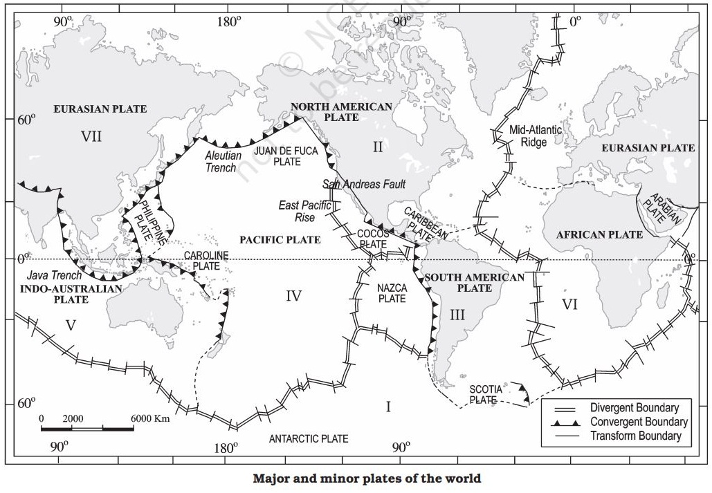
Consider the following pairs of Minor Plates:
Which of the above pairs are correctly matched?
1, 2 and 3 only
3 and 4 only
2, 3 and 4 only
1, 2 and 4 only
Correct Answer : D
Explanation
Some important minor plates are listed below:
- Cocos plate : Between Central America and Pacific plate
- Nazca plate : Between South America and Pacific plate
- Arabian plate : Mostly the Saudi Arabian landmass
- Philippine plate : Between the Asiatic and Pacific plate
- Caroline plate : Between the Philippine and Indian plate (North of New Guinea)
- Fuji plate : North-east of Australia.
- The Scotia Plate is in the South Atlantic Ocean near Falkland Islands. Hence, option (d) is the correct answer.
Question 8:
Crust is destroyed along which of the following plate boundaries ?
- Convergent Boundary
- Divergent Boundary
- Transform Boundary
Select the correct answer using the code given below.
1 only
1 and 2 only
2 and 3 only
1 and 3 only
Correct Answer : A
Explanation
- A convergent boundary is where the crust is destroyed as one plate dives under another. The location where sinking of a plate occurs is called a subduction zone. Hence option (a) is the correct answer.
- The Indian plate includes Peninsular India and the Australian continental portions. The subduction zone along the Himalayas forms the northern plate boundary in the form of continent- continent convergence.
Question 9:
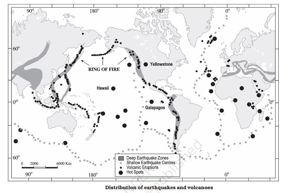
Consider the following statements about Ring of fire:
- Ring of fire coincides with the volcanic zone as well as the earthquake zones of the world.
- Ring of fire is parallel to the mid oceanic ridge where divergent boundaries exist.
Which of the statements given above is/are correct.
1 only
2 only
Both 1 and 2
Neither 1, nor 2
Correct Answer : A
Explanation
- The Ring of Fire, also referred to as the Circum-Pacific Belt, is a path along the Pacific Ocean characterized by active volcanoes and frequent earthquakes. The majority of Earth's volcanoes and earthquakes take place along the Ring of Fire. Ring of fire can be located in the given map and it is not parallel to the mid oceanic ridge. Hence, only statement 1 is the correct option (a) is the correct answer.
Question 10:
Which of the following is/are the evidence of seafloor spreading?
- Volcanic activity along the mid-oceanic ridges.
- Increasing age of rocks away from the oceanic ridges.
- Similarities of magnetic properties on either side of oceanic ridges.
Select the correct answer using the code given below.
1 and 2 only
2 and 3 only
3 only
1, 2 and 3
Correct Answer : A
Explanation
- All along the mid-oceanic ridges, volcanic eruptions are common and they bring huge amounts of lava to the surface in this area.
- The age of the rocks increases as one moves away from the crest. The rocks equidistant on either side of the crest of mid-oceanic ridges show remarkable similarities in terms of period of formation, chemical compositions and magnetic properties.
- Rocks closer to the mid-oceanic ridges are normal polarity and are the youngest. Hence all the given statements are evidence of seafloor spreading and option (d) is the correct answer.