Xiaokang Villages and India's Border Security | 16 Mar 2026
For Prelims: Line of Actual Control (LAC), Salami-slicing Tactics, 2005 India-China Agreement on Political Parameters and Guiding Principles, Siliguri Corridor, Vibrant Villages Programme, Zojila Tunnel, Sela Tunnel, Border Roads Organisation (BRO), Nyoma Airbase, PM GatiShakti framework.
For Mains: Key facts regarding the Xiaokang border defence villages and threats posed to India. Steps India needs to take to strengthen its border infrastructure.
Why in News?
India’s Military leadership warned that China’s rapid construction of 628 "Xiaokang" villages along the Line of Actual Control (LAC), particularly the 90% cluster facing Arunachal Pradesh, is a strategic move to solidify territorial claims through civilian settlement.
- These dual-use villages in contested areas essentially function as permanent, fortified outposts, creating a significant long-term security and sovereignty challenge for India.
Summary
- China is constructing 628 dual-use Xiaokang villages to strengthen territorial claims through "salami-slicing" tactics along the LAC.
- These settlements facilitate military-civil fusion and constant surveillance, pressuring India’s northeastern borders.
- Consequently, India is accelerating the Vibrant Villages Programme and Arunachal Frontier Highway to bolster strategic deterrence.
What are the Xiaokang Border Defence Villages?
- About: Chinese ‘Xiaokang’ Villages refer to a specific category of border settlements constructed or upgraded, primarily in the Tibet Autonomous Region (TAR) along its disputed frontiers. The term "Xiaokang" translates to "moderately prosperous" or "well-off" in English.
- Scale and Investment: Launched around 2017 by the Tibet Autonomous Region (TAR) government, the project involves 628 villages across 21 border counties (3rd level administrative division after prefecture-level cities and provinces) with a state investment of approximately 30 billion yuan.
- Dual-Use Functionality: While framed as rural revitalisation, these settlements serve as dual-use infrastructure, capable of housing People's Liberation Army (PLA) personnel and facilitating rapid military mobilization in contested areas.
- Legal and Strategic Framework: The construction is supported by China's 2022 Land Border Law, which mandates the state to strengthen border defense and promote "coordination between border defense and social, economic development."
- It acts as a "Great Wall of Villages" to strengthen de facto control and territorial claims through "gray-zone" tactics.
- Demographic Engineering: The initiative aims to enhance grassroots Chinese Communist Party control, monitor cross-border activity, and promote Sinicization in Tibet (adoption of Chinese culture and identity) by populating sensitive border zones.
- Infrastructure Sophistication: Beyond housing, the project provides comprehensive modern amenities, including roads, electricity, water supply, and communications, often documented via satellite imagery.
Line of Actual Control
- About: The Line of Actual Control (LAC) is a notional, de facto demarcation line that separates Indian-controlled territory from Chinese-controlled territory, emerging primarily from the post-1962 war positions in the absence of a formally delineated international border.
- Origin: First proposed by Chinese Premier Zhou Enlai in 1959, the concept was initially rejected by India’s former Prime Minister JL Nehru but later formally accepted by India in the 1993 Border Peace and Tranquility Agreement (BPTA) to maintain regional stability.
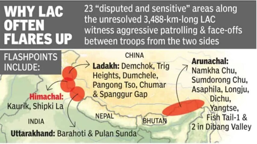
- Sectoral Division: The LAC is divided into the Western Sector (Ladakh/Aksai Chin), which sees the most friction; the Middle Sector (Uttarakhand/Himachal Pradesh), which is the least disputed; and the Eastern Sector (Arunachal Pradesh/Sikkim), which largely follows the McMahon Line.
- In the Eastern Sector, India recognizes the 1914 Simla Convention's McMahon Line, whereas China rejects its legal validity, referring to Arunachal Pradesh as "South Tibet."
- Perception Gap: A major source of conflict is the discrepancy in length, where India estimates the LAC at 3,488 km while China claims it is only about 2,000 km, leading to overlapping claims in "grey zones."
- Friction Points: Ambiguity in the rugged Himalayan terrain leads to "face-offs" at critical locations such as Depsang Plains, Galwan Valley, Pangong Tso, and Tawang.
How do Xiaokang Border Defence Villages Pose a Threat to India?
- Territorial Assertion: By establishing a "settled population" in disputed areas, China aims to strengthen legal claims under its Land Borders Law (2022), utilizing "salami-slicing" tactics to change the status quo without triggering full-scale conflict.
- Breach of Bilateral Agreements: These constructions are viewed as a violation of the 2005 India-China Agreement on Political Parameters and Guiding Principles, specifically undermining articles related to mutual security and the maintenance of peace and tranquility along the border.
- Dual-Use Infrastructure: Settlements at sites like Zhuangnan and Majiduncun function as forward operating bases, featuring robust logistics, communication networks, and housing designed for rapid PLA mobilization.
- Military-Civil Fusion: Residents act as the state’s "eyes and ears," forming a civilian border defense force that provides constant surveillance, early warning, and intelligence collection against Indian movements.
- Strategic Pressure Points: The placement of these villages near sensitive zones like Tawang and the Siliguri Corridor ("Chicken’s Neck") creates persistent geostrategic pressure on India’s northeastern connectivity.
- Psychological Warfare: The visible modernization of Chinese villages is intended to exert psychological pressure on Indian border communities. This disparity may foster perceptions of relative neglect on the Indian side, indirectly supporting China's narrative of superior governance.
India’s Initiatives to Strengthen Border Infrastructure
What Steps Does India Need to Take to Strengthen its Border Infrastructure?
- Strategic Logistical Connectivity: Accelerate Phase III of the India-China Border Roads (ICBR) programme and flagship projects like the 1,840 km Arunachal Frontier Highway to guarantee all-weather troop mobilization and seamless logistics.
- Civilian-Led Defense: Expand the Vibrant Villages Programme (Phase II) to transform 1,954 border villages into self-sufficient hubs, effectively countering out-migration and creating a "civilian monitoring layer" along the LAC.
- High-Altitude Infrastructure: Prioritize the construction of strategic tunnels (e.g., Zojila, Sela) and all-weather rail links to eliminate seasonal isolation and facilitate the rapid movement of heavy weaponry.
- Aerial and Multimodal Readiness: Upgrade Advanced Landing Grounds (ALGs) like Nyoma airbase and expand helipad networks to support heavy-lift operations and high-resolution aerial reconnaissance.
- Technological Surveillance Integration: Deploy a multi-layered ISR (Intelligence, Surveillance, and Reconnaissance) framework—utilizing 150+ new satellite assets, AI-driven analytics, and drones—to maintain constant situational awareness.
- Energy and Institutional Synergy: Implement renewable energy micro-grids for forward outposts to ensure logistical self-sufficiency while leveraging the PM GatiShakti framework to fast-track inter-ministerial clearances for BRO projects.
- Diplomatic Deterrence: Complement physical infrastructure with sustained engagement through the Working Mechanism for Consultation and Coordination (WMCC) to manage tensions and prevent unintended escalation.
Conclusion
China’s Xiaokang border villages represent a strategic blend of civilian settlement, infrastructure development, and military preparedness aimed at consolidating territorial claims along the Line of Actual Control. For India, the development underscores the urgency of strengthening border infrastructure, surveillance, and local population resilience to safeguard sovereignty and maintain strategic balance in sensitive frontier regions.
|
Drishti Mains Question: Analyze the strategic implications of China’s "Xiaokang" border villages on India's national security and territorial sovereignty. |
Frequently Asked Questions (FAQs)
1. What are Xiaokang border defence villages?
Xiaokang villages are Chinese border settlements built in the Tibet Autonomous Region to promote economic development and strengthen border defence, often serving dual civilian–military purposes.
2. Which law supports the construction of Xiaokang villages?
The China Land Border Law, 2022 mandates strengthening border defence, developing infrastructure, and encouraging civilian settlement in frontier areas.
3. What is India’s response to China’s border village strategy?
India launched the Vibrant Villages Programme to develop border villages, strengthen infrastructure, and retain population along the frontier.
4. What is meant by “gray-zone tactics” in border disputes?
Gray-zone tactics involve incremental actions—such as infrastructure development or civilian settlement—that alter territorial control without triggering open conflict.
UPSC Civil Services Examination, Previous Year Question (PYQ)
Prelims
Q. “Belt and Road Initiative” is sometimes mentioned in the news in the context of the affairs of : (2016)
(a) African Union
(b) Brazil
(c) European Union
(d) China
Ans: (d)
Q.‘Hand-in-Hand 2007’ a joint anti-terrorism military training was held by the officers of the Indian Army and officers of the Army of which one of the following countries? (2008)
(a) China
(b) Japan
(c) Russia
(d) USA
Ans: (a)
Mains
Q. The China-Pakistan Economic Corridor (CPEC) is viewed as a cardinal subset of China’s larger ‘One Belt One Road’ initiative. Give a brief description of CPEC and enumerate the reasons why India has distanced itself from the same. (2018)