NavIC | 27 Oct 2022
For Prelims: ISRO, GPS, IMO, IRNSS, L Band, GLONASS, Galileo, BeiDou.
For Mains: Significance of NavIC.
Why in News?
Indian plans to expand its regional satellite navigation system NavIC (Navigation in Indian Constellation), to increase its use in the civilian sector and ships, aircraft travelling far from the country's borders.
What is NavIC?
- About:
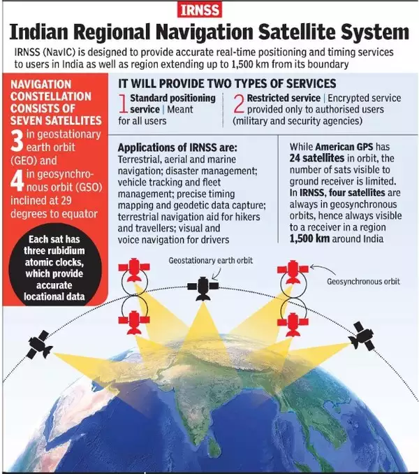
- NavIC or the Indian Regional Navigation Satellite System (IRNSS) is designed with a constellation of 7 satellites and a network of ground stations operating 24×7.
- There are a total of eight satellites however only seven remain active.
- Three satellites in geostationary orbit and four satellites in geosynchronous orbit.
- The constellations' first satellite (IRNSS-1A) was launched on 1st July 2013 and the eighth satellite IRNSS-1I was launched in April 2018.
- With the seventh launch of the constellation's satellite (IRNSS-1G), IRNSS was renamed NavIC by India’s Prime Minister in 2016.
- It was recognised by the International Maritime Organization (IMO) as a part of the World-Wide Radio Navigation System (WWRNS) for operation in the Indian Ocean Region in 2020.
- NavIC or the Indian Regional Navigation Satellite System (IRNSS) is designed with a constellation of 7 satellites and a network of ground stations operating 24×7.
- Potential Uses:
- Terrestrial, aerial and marine navigation;
- Disaster management;
- Vehicle tracking and fleet management (especially for mining and transportation sector);
- Integration with mobile phones;
- Precise timing (as for ATMs and power grids);
- Mapping and geodetic data capture.
What is the Significance?
- It gives real time information for 2 services i.e standard positioning service open for civilian use and Restricted service which may be encrypted for authorized users like for military.
- India became one of the 5 countries having their own navigation system. So, India's dependence on other countries for navigation purposes reduces.
- It will help scientific & technological advancement in India. It is important for the country’s sovereignty and strategic requirements.
- In April 2019, the government made NavIC-based vehicle trackers mandatory for all commercial vehicles in the country in accordance with the Nirbhaya case verdict.
- Also, Qualcomm Technologies has unveiled mobile chipsets supporting NavIC
- Further with extensive coverage, one of the stated future uses of the project includes sharing of the project with the SAARC nations. This will help in integrating the regional navigation system further and a diplomatic goodwill gesture from India towards countries of the region.
What are the Issues and Intended Improvements?
- L Band:
- ISRO plans to replace at least five satellites with the improved L-Band, which would enable it to offer better global positioning services to the public as several satellites of the constellation have outlived their lives.
- Five more satellites will be launched periodically to replace the defunct satellites.
- The new satellites will have L-1, L-5 and S Band.
- L1, L2 and L5 are GPS frequencies, where L1 frequency is used to track GPS satellite location, L2 frequency is used to track the health of the GPS satellites and the L5 frequency is used to improve accuracy for civilian use such as aircraft precision.
- S band operate on a wavelength of 8-15 cm and a frequency of 2-4 GHz. Because of the wavelength and frequency, S band radars are not easily attenuated. This makes them useful for near and far range weather observation.
- ISRO plans to replace at least five satellites with the improved L-Band, which would enable it to offer better global positioning services to the public as several satellites of the constellation have outlived their lives.
- Long Code for Strategic Sector:
- Currently ISRO is providing only short code. Now, the short code has to become long code for strategic sector use so that the signal cannot be breached or spoofed or made non-available.
- It will be done so that the user base can be widened and to make it user friendly.
- Mobile Compatibility:
- Currently, the mobile phones in India haven’t been made compatible to process its signals.
- The Indian government has been pressing manufacturers to add compatibility and has set a deadline of January 2023 but media reports suggest this is unlikely before 2025.
Which are the other Navigation Systems operational in the world?
- Four global systems:
- GPS from the U.S.
- GLONASS from Russia.
- Galileo from European Union
- BeiDou from China.
- Two regional systems:
- NavIC from India
- QZSS from Japan.
What is the need for NavIC when already others are Operating?
- GPS and GLONASS are operated by defence agencies of the respective nations.
- It is possible that the civilian service can be degraded or denied.
- NavIC is an independent regional system over the Indian region and does not depend on other systems for providing position service within the service region.
- It is fully under the control of the Government of India.
Way Forward
- To make NavIC truly global like GPS, more satellites would need to be placed in an orbit closer to earth than the current constellation.
- Right now, NavIC’s reach is only 1,500 km beyond Indian territory. But for our ships and airplanes travelling beyond that we’d need satellites in Medium Earth Orbit. To make this global at some point, we can keep adding MEO satellites.
UPSC Civil Services Examination Previous Year Question
Prelims
Q. With reference to the Indian Regional Navigation Satellite System (IRNSS), consider the following statements: (2018)
- IRNSS has three satellites in geostationary and four satellites in geosynchronous orbits.
- IRNSS covers entire India and about 5500 sq. Km beyond its borders.
- India will have its own satellite navigation system with full global coverage by the middle of 2019.
Which of the statements given above is/are correct?
(a) 1 only
(b) 1 and 2 only
(c) 2 and 3 only
(d) None
Ans: (a)
Mains
Q. Why is Indian Regional Navigational Satellite System (IRNSS) needed? How does it help in navigation? (2018)
Source: TH