Kalapani Territory | 08 Nov 2019
Why in News
In the recently released political map of India, after the bifurcation of the state of Jammu and Kashmir (J&K) into the Union Territories of J&K and Ladakh, the Kalapani territory became the bone of contention between India and Nepal.
Key Points
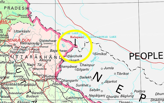
- In the latest political map of India, India reiterated its claims on the region that Nepal considers its own territory in Darchula district.
- According to India, the historic Kalapani region forms part of the state of Uttarakhand.
- Background: Kalapani is a valley that is administered by India as a part of the Pithoragarh district of Uttarakhand. It is situated on the Kailash Mansarovar route.
- The Kali River in the Kalapani region demarcates the border between India and Nepal.
- The Treaty of Sugauli signed by the Kingdom of Nepal and British India (after Anglo-Nepalese War) in 1816 located the Kali River as Nepal's western boundary with India. The discrepancy in locating the source of the river led to boundary disputes between India and Nepal, with each country producing maps supporting their own claims.
- In the recent map issued by the Indian government, the Pakistan-occupied Kashmir forms the part of the newly-created Union Territory of Jammu and Kashmir, while Gilgit-Baltistan is located in the Union Territory of Ladakh.
- Susta area is one of the disputed territories between India (Uttar Pradesh) and Nepal.
- Susta is located on the bank of the Gandak river (called Narayani river in Nepal).
- The change of course by the Gandak river is the main reason for disputes in the Susta area.
- The area is very fertile for agriculture because of the alluvial soil brought by the river.
Kali River
- It is also known as Sharda river or Kali Ganga in Uttarakhand.
- It joins Ghagra river in Uttar Pradesh, which is a tributary of Ganga.
- River Projects: Tanakpur hydro-electric project, Chameliya hydro-electric project, Sharda Barrage.