International Relation | 26 Sep 2021
Armenia
Context
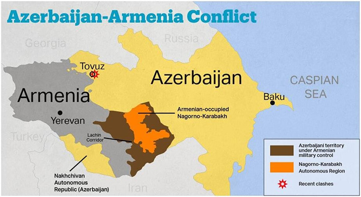
Recently, a territorial dispute between Armenia and Azerbaijan over the Nagorno-Karabakh region has re-erupted with heavy clashes.
About Armenia
- The capital is Yerevan.
- Armenia is the country of Transcaucasia. To the north and east, Armenia is bounded by Georgia and Azerbaijan, while its neighbours to the southeast and west, respectively, are Iran and Turkey.
- Most of the rivers fall into the drainage area of the Aras (itself a tributary of the Kura river of the Caspian basin), which forms a natural boundary between Armenia and Turkey and Iran.
- Armenia contains two terrestrial ecoregions: Caucasus mixed forests and Eastern Anatolian montane steppe.
- Azerbaijan falls along the International North-South Transport Corridor route, connecting India with Russia through central Asia.
Nagorno-Karabakh Conflict
- Nagorno-Karabakh is part of Azerbaijan, but its population is majority Armenian.
- As the Soviet Union saw increasing tensions in its constituent republics in the 1980s, Nagorno-Karabakh voted to become part of Armenia - sparking a war that stopped with a ceasefire in 1994.
- Since then, Nagorno-Karabakh has remained part of Azerbaijan but is controlled by separatist ethnic Armenians backed by the Armenian government.
- Armenia is majority Christian while Azerbaijan is majority Muslim. Turkey has close ties to Azerbaijan, while Russia is allied with Armenia - although it also has good relations with Azerbaijan.
NOTE: Transcaucasia, also known as the South Caucasus, is a geographical region on the border of Eastern Europe and Western Asia, straddling the southern Caucasus Mountains. Transcaucasia roughly corresponds to modern Georgia, Armenia, and Azerbaijan.
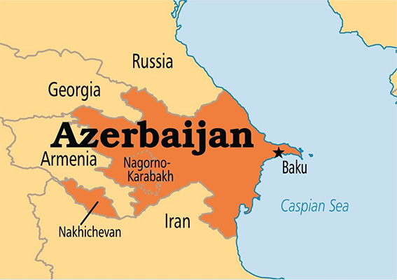
Azerbaijan
Context
The virtual Non-Aligned Movement meet of 2020 was hosted by the President of Azerbaijan.
About Azerbaijan
- The capital of Azerbaijan is the ancient city of Baku based on the Caspian Sea.
- Occupying an area that fringes the southern flanks of the Caucasus Mountains, it is bounded on the north by Russia, on the east by the Caspian Sea, on the south by Iran, on the west by Armenia, and on the northwest by Georgia.
- The highest peaks are Bazardyuzyu , Shakhdag, and Tufan - all part of the Greater Caucasus range.
- Major rivers are Kura (Source - Turkey) and Aras (Source - Turkey) and drain into the Caspian sea.
About Caspian Sea
- The Caspian Sea is the largest salt lake in the world. It is the world's largest inland body of water, variously classed as the world's largest lake or a full-fledged sea.
- It lies to the east of the Caucasus Mountains and to the west of the vast steppe of Central Asia. The sea’s name derives from the ancient Kaspi peoples, who once lived in Transcaucasia to the west.
- The sea is bordered in the northeast by Kazakhstan, in the southeast by Turkmenistan, in the south by Iran, in the southwest by Azerbaijan, and in the northwest by Russia.
- The major rivers - the Volga (Europe’s longest river), Ural, and Terek - empty into the northern Caspian Sea, along with the Sulak, Samur, Kura, and a number of smaller rivers.
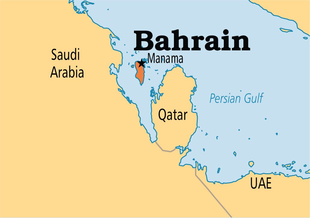
Bahrain
Context
The Abraham Accord was signed between Israel and Bahrain. It was mediated by the USA.
About Bahrain
- Bahrain is a small Arab state situated in a bay on the southwestern coast of the Persian Gulf.
- It is an archipelago consisting of Bahrain Island and some 30 smaller islands. Its name is from the Arabic term al-bahrayn, meaning “two seas”.
- The country’s chief city, port, and capital, Manama (Al-Manamah), is located on the northeastern tip of Bahrain Island.
- The country is situated between the Qatari peninsula and the northeastern coast of Saudi Arabia to which it is connected by the 25-kilometre King Fahd Causeway.
- Bahrain is the site of the ancient Dilmun civilization.
Abraham Accord
- In September 2020, the US mediated between Israel and the United Arab Emirates & Bahrain for the signing of the historic Abraham Accord, which is the first Arab-Israeli peace deal in 26 years.
- As per the agreements, the UAE and Bahrain will work together with Israel across a range of sectors, including tourism, trade, healthcare and security.
- Since Israeli independence in 1948, it has fought several wars with Arab neighbouring countries. While the persecuted Jews saw Israel as their promised home, the Arabs saw it as an occupation.
- Till the signing of the Abraham Accords, there were only two peace deals between Israel and the Arab States. Egypt was the first Arab State to sign a peace deal with Israel in 1979. Jordan signed a peace pact in 1994.
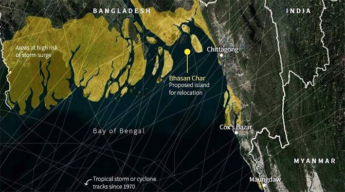
Bhashan Char Island
Context
The Rohingya refugees living in Bangladesh camps have been rehabilitated to Bhashan Char Island.
About Bhashan Char Island
- The island is also known as Char Piya and Thengar Char.
- It is located in the Bay of Bengal.
- The island was formed around 20 years ago at the estuary of the Meghna river with silt from the Ganga, Brahmaputra and Meghna. Much of the island rose above sea level as recently as 2006.
- Bangladesh wanted to move nearly 100,000 Rohingya refugees to the island to take the pressure off the overcrowded border camps.
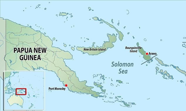
Bougainville Island
Context
The residents of the Bougainville Island sought a referendum to split from Papua New Guinea.
About
- Bougainville Island is the easternmost island of Papua New Guinea, in the Solomon Sea, southwestern Pacific. With Buka Island and several island groups, it forms the autonomous region of Bougainville.
- Geographically, Bougainville is the largest of the Solomon Islands, located near the northern end of that chain.
- Emperor Range, with its highest peak at Balbi and Bagana (both active volcanoes) occupies the northern half of the island, and the Crown Prince Range occupies the southern half.
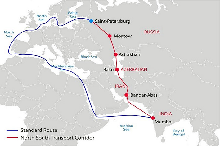
International North-South Transport Corridor
Context
The International North-South Transport Corridor (INSTC) connected Europe with India (mainly through territorial route) for the first time with a Finnish logistics company despatching a consignment from Finland to India.
About INSTC
- INSTC is a 7,200-km-long multi-mode network of ship, rail, and road routes. The route primarily involves moving freight from India, Iran, Azerbaijan and Russia.
- The major cities involved are Mumbai, Bandar Abbas, Tehran, Baku, Astrakhan, Moscow, etc.
- It is also in consonance with the Ashgabat agreement, a Multimodal transport agreement signed by India (2018 - year of joining), Oman (2011), Iran (2011), Turkmenistan (2011), Uzbekistan (2011) and Kazakhstan (2015).
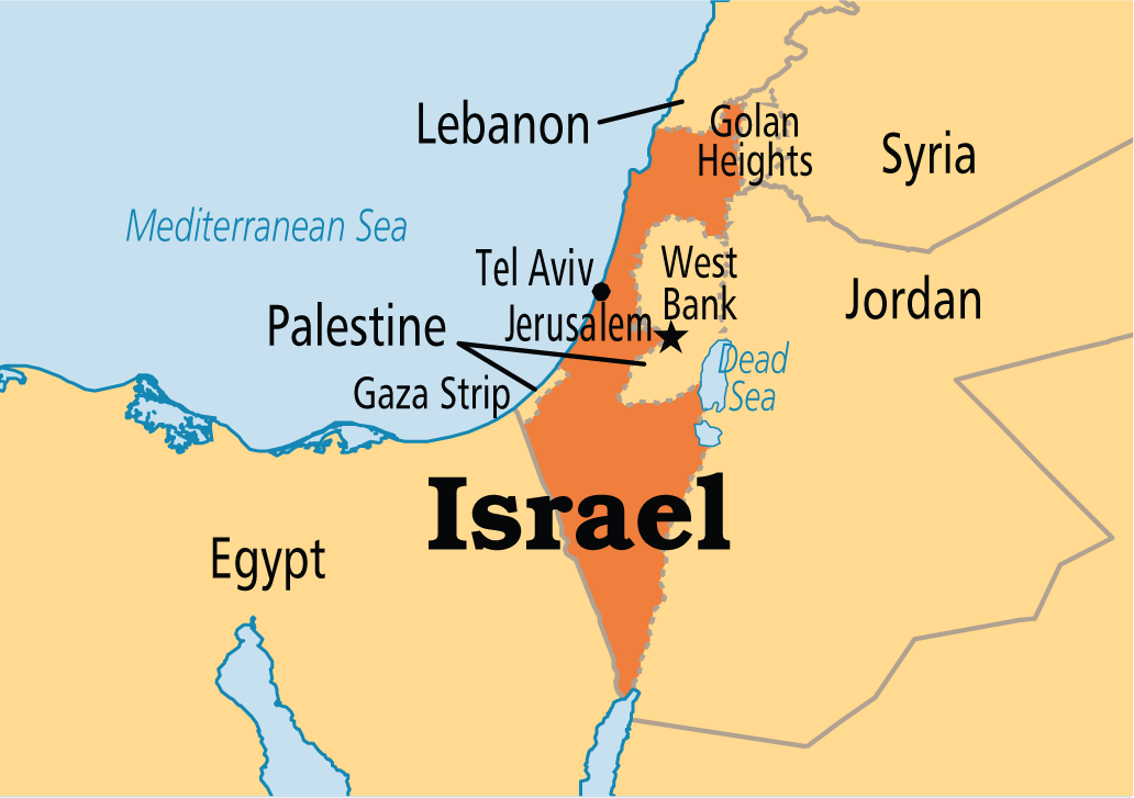
Israel
Context
The Israel-Palestine conflict witnessed a new rise.
About Israel
- Israel is a country in Western Asia, located on the southeastern shore of the Mediterranean Sea and the northern shore of the Red Sea.
- It has land borders with Lebanon to the north; Syria to the northeast; Jordan and the Palestinian territories of the West Bank to the east; the Palestinian territories of the Gaza Strip to the west; and Egypt to the southwest.
- The Jordan river marks part of the frontier between Israel and Jordan. The Jordan river runs along the Jordan Rift Valley, from Mount Hermon through the Hula Valley and the Sea of Galilee to the Dead Sea, the lowest point on the surface of the Earth.
Related Information
- Recently, a new human species was discovered in Nesher Ramla, Israel.
- The Nesher Ramla Homo group are an extinct population of archaic humans who lived during the Middle Pleistocene in modern-day Israel.
Kenya
Context
Scientists have discovered the oldest human burial (nearly 80,000-year-old grave) at Panga ya Saidi cave located in Kenya. The scientists have nicknamed the youngster ‘Mtoto,’ meaning ‘child’ in Swahili.
About Kenya
- Kenya, with capital Nairobi, is a country in Eastern Africa bisected horizontally by the Equator.
- Kenya is bordered by South Sudan to the northwest, Ethiopia to the north, Somalia to the east, Uganda to the west, Tanzania to the south, and the Indian Ocean to the southeast.
- Maasai, Luhya, Luo, Kalenjin, and Kikuyu are the important tribes living there.
- From the coast of the Indian Ocean, the low plains rise to central highlands. The highlands are bisected by the Great Rift Valley, with a fertile plateau lying to the east.
- The highlands are the site of the highest point in Kenya and the second-highest peak on the continent, Mount Kenya - which with a height of 5,199 m (17,057 ft) is a site of glaciers.
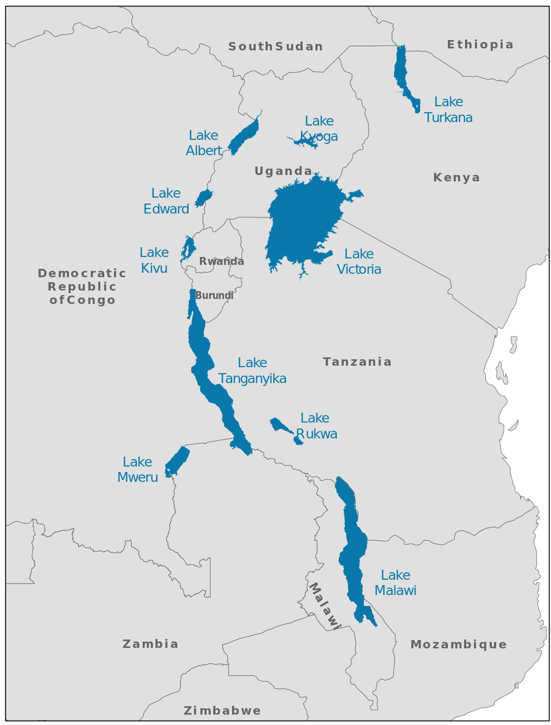
Kivu
Context
The Kivu region of Eastern Democratic Republic of the Congo (DRC) in Africa has been marred with an ethnic war over rights to natural resources.
About Kivu
- Kivu is a region of the DRC bordering the countries of Burundi, Rwanda, Tanzania, and Uganda.
- The Kivu region represents the high point of the East African Rift Valley.
- Lake Kivu is one of the great lakes of East Africa, situated between DRC to the west and Rwanda to the east.
About Democratic Republic of Congo
- Formerly known by the name of Zaire, it is a country in Central Africa. The country is cut across by the Equator.
- It is, by area, the largest country in sub-Saharan Africa and the second-largest in all of Africa (after Algeria).
- It is bordered
- to the north by the Central African Republic,
- to the northwest by the Republic of the Congo,
- to the northeast by South Sudan,
- to the east by Uganda, Rwanda and Burundi, and by Tanzania (across Lake Tanganyika),
- to the south and southeast by Zambia,
- to the southwest by Angola, and
- to the west by the South Atlantic Ocean and the Cabinda Province exclave of Angola.
- The area sustains the Congo Rainforest, the second-largest rainforest in the world after the Amazon.
- The capital, Kinshasa, is located on the Congo River.
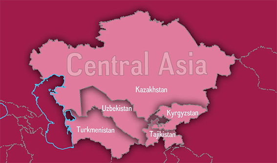
Kyrgyzstan
Context
Kyrgyzstan and Tajikistan recently engaged in border clashes.
Key points
- The fighting was because of the water facilities in territory claimed by both Kyrgyzstan and Tajikistan. The meandering boundary between the two countries is particularly tense as over a third of it is disputed. Restrictions on access to land and water that communities regard as theirs have often led to deadly clashes in the past.
- Kyrgyzstan and Tajikistan, both came into existence after the disintegration of the Union of Soviet Socialist Republics (USSR).
- Kyrgyzstan, with its capital Bishkek, is a landlocked country in Central Asia. It is bounded by Kazakhstan on the northwest and north, by China on the east and south, and by Tajikistan and Uzbekistan on the south and west.
- Tajikistan, with its capital Dushanbe, is also a landlocked country lying south of Kyrgyzstan. It is bordered by China on the east, Afghanistan on the south, and Uzbekistan on the west and northwest.
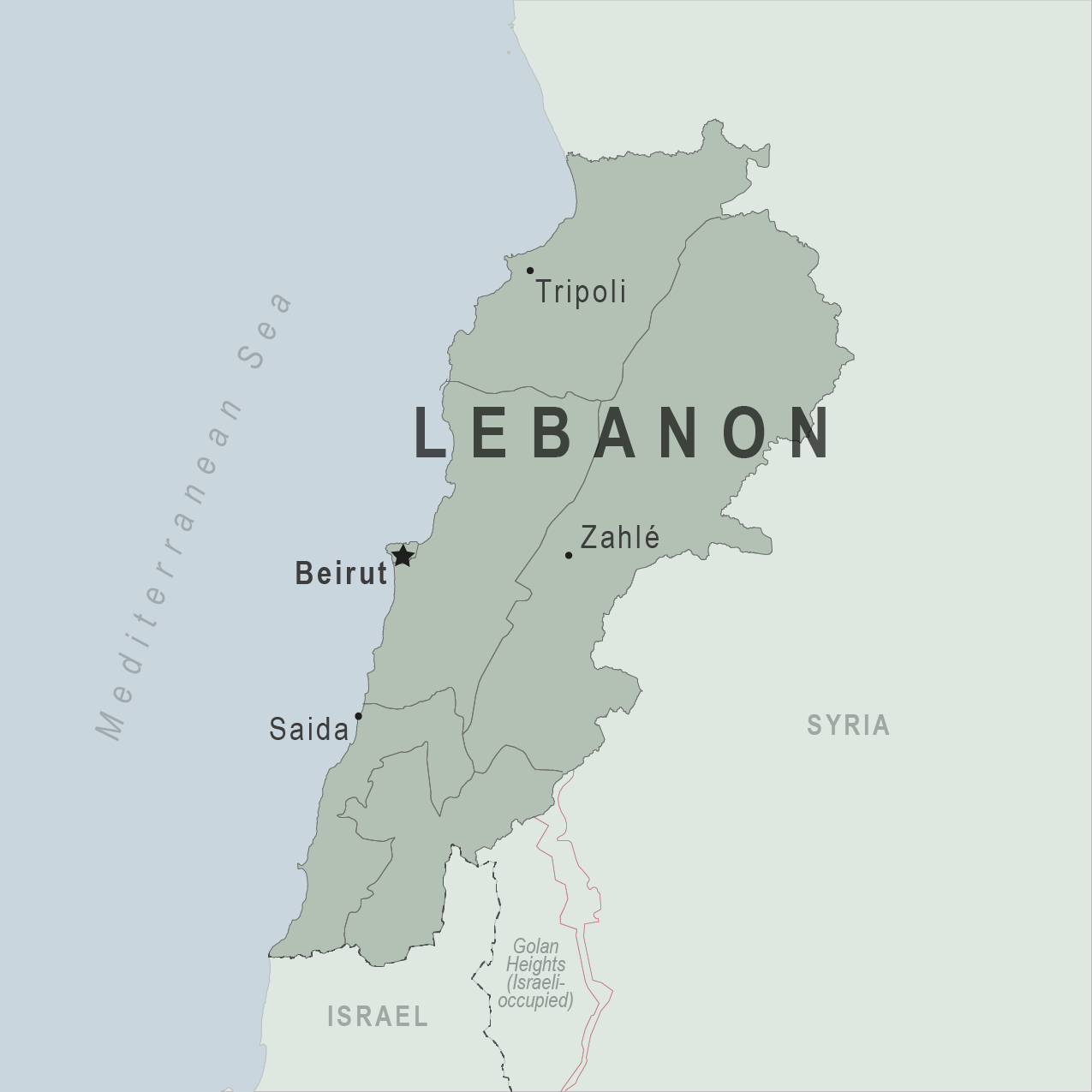
Lebanon
Context
On 4 August 2020, a large amount of ammonium nitrate stored at the port of the city of Beirut, the capital of Lebanon, exploded.
About Lebanon
- Beirut is the capital and largest city of Lebanon situated at the coast of Mediterranean sea.
- It is flanked by the Lebanon Mountains and has taken on a triangular shape, largely influenced by its situation between and atop two hills: Al-Ashrafieh and Al-Musaytibah.
- It is bordered by Syria to the north and east and Israel to the south, while Cyprus lies west across the Mediterranean Sea.
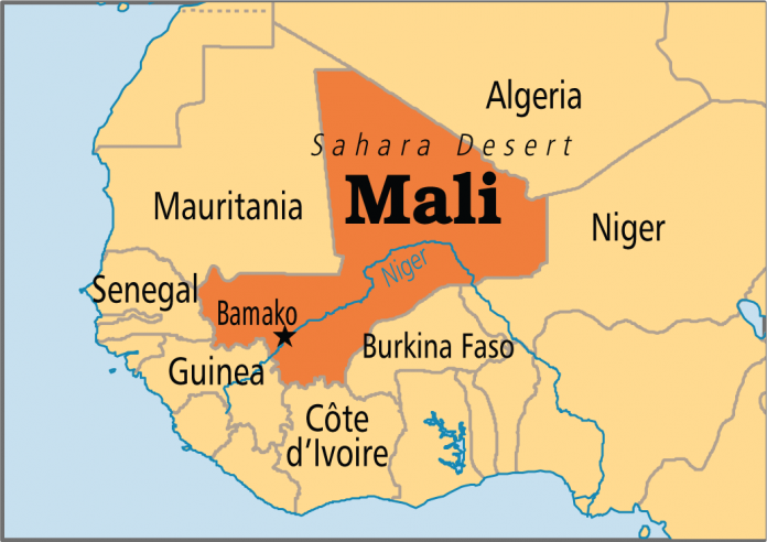
Mali
Context
In late May 2021, Mali’s military carried out a coup against its interim government.
About Mali
- Mali, with capital Bamako, is a landlocked country of western Africa, mostly in the Saharan and Sahelian region.
- Mali is bounded on the north by Algeria, on the east by Niger and Burkina Faso, on the south by Côte d’Ivoire and Guinea, and on the west by Senegal and Mauritania.
- The Niger River flows through its interior, functioning as the main trading and transport artery in the country.
- The Bambara (Bamana) ethnic group and language predominate, with several other groups - including the Fulani (Fulbe), Dogon, and Tuareg - present in the population.
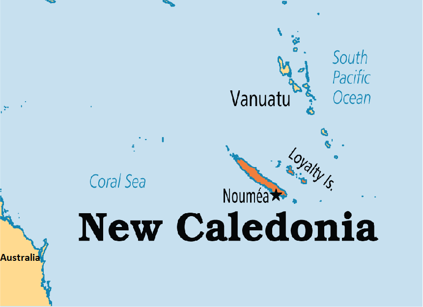
New Caledonia
Context
The French territory of New Caledonia voted against independence from France in a referendum held recently.
About New Caledonia
- New Caledonia is a special collectivity of France in the southwest Pacific Ocean, south of Vanuatu, east of Australia.
- New Caledonia is part of Zealandia, a fragment of the ancient Gondwana supercontinent.
- New Caledonia’s lagoons, with their diverse reefs and associated ecosystems, were designated a UNESCO World Heritage site in 2008.
- New Caledonia’s highest point is Mount Panie.
- The Diahot river is the longest river in the country.
- New Caledonia is home to the New Caledonian crow, a bird noted for its tool-making abilities, which rival those of primates.
- New Caledonia is a territory sui generis to which France has gradually transferred certain powers. As such its citizens have French nationality and vote for the President of France. They have the right to vote in elections to the European Parliament.
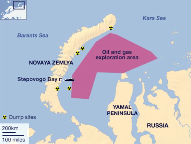
Novaya Zemlya
Context
Russia tested the world's most powerful hydrogen bomb in Novaya Zemlya.
About Novaya Zemlya
- Novaya Zemlya is an archipelago of Russia. It is situated in the Arctic Ocean, in the extreme northeast of Europe.
- It houses the easternmost point of Europe lying at Cape Flissingsky.
- To Novaya Zemlya's west lies the Barents Sea, and to the east is the Kara Sea.
- Novaya Zemlya is composed of two main islands, the northern Severny Island and the southern Yuzhny Island, which are separated by the Matochkin Strait.
Persian Gulf
Context
India has been maintaining a fleet of warships in the Persian Gulf to aid its merchant ships.
About Persian Gulf
- It is a shallow marginal sea of the Indian Ocean that lies between the Arabian Peninsula and southwestern Iran.
- It is bordered
- on the north, northeast, and east by Iran;
- on the southeast and south by part of Oman and by the United Arab Emirates;
- on the southwest and west by Qatar, Bahrain, and Saudi Arabia; and
- on the northwest by Kuwait and Iraq.
- In the northwest, immense quantities of silt are deposited by the Tigris, Euphrates, and Karun rivers.
- Safaniya Oil Field, the world's largest offshore oilfield, is located in the Persian Gulf.
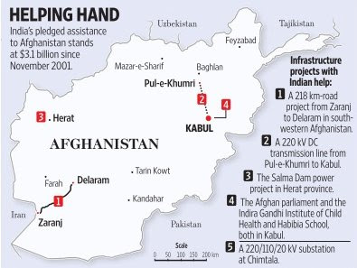
Shahtoot Dam
Context
India and Afghanistan have signed an agreement to build the Shahtoot Dam in Kabul to provide drinking water in the Afghanistan capital.
Key points
- Earlier India has built Salma Dam (India-Afghanistan Friendship Dam) on the Hari river in Afghanistan.
- Afghanistan, with capital Kabul, is a mountainous landlocked country at the crossroads of Central and South Asia.
- Afghanistan is bordered by Pakistan to the east and south; India to the south east (through the Pakistan Occupied Kashmir); Iran to the west; Turkmenistan, Uzbekistan, and Tajikistan to the north; and China to the northeast.
- Afghanistan shares its longest land border (the Durand Line) with Pakistan to the east and south.
- Major rivers of Afghanistan include Kabul, Amu Darya, Harirud, and Helmand.
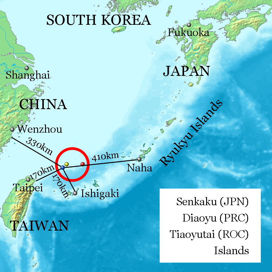
Senkaku Islands
Context
Recently, a local council in southern Japan approved a bill to change the name of an area containing Senkaku Islands from Tonoshiro to Tonoshiro Senkaku.
About Senkaku Islands
- These are a group of uninhabited islands in the East China Sea and are disputed territory between China, Taiwan and Japan.
- These are located east of China, northeast of the Republic of China, west of Okinawa Island, and north of the southwestern end of the Ryukyu Islands.
Sinai Peninsula
Context
The Egyptian Army recently launched raids and air attacks targeting terrorist hideouts in Bir al-Abed, Rafah and Sheikh Zuweid, in the Sinai peninsula area.
About Sinai Peninsula
- The Sinai Peninsula is a peninsula in Egypt and is the only part of the country located in Asia. Egypt is majorly located in Africa.
- Sinai is located between the Mediterranean Sea to the north and the Red Sea to the south and is a land bridge between Asia and Africa.
- The Sinai Desert, as the peninsula’s arid expanse is called, is separated by the Gulf of Suez and the Suez Canal from the Eastern Desert of Egypt, but it continues eastward into the Negev desert without marked change of relief.
- It is linked to the African continent by the Isthmus of Suez.

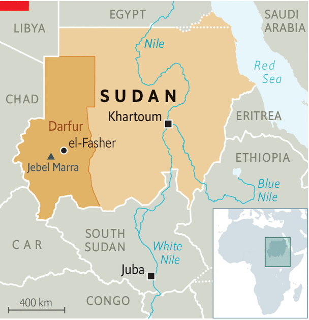
Sudan
Context
A war has been going on in the Darfur region of Sudan.
About Darfur
- The war began in February 2003 when the Sudan Liberation Movement (SLM) and the Justice and Equality Movement (JEM) rebel groups began fighting the government of Sudan, which they accused of oppressing Darfur's non-Arab population.
- Darfur is largely a semi-arid plateau with the Marrah Mountains (Jebel Marra), a range of volcanic peaks rising up to 3,042 meters (9,980 ft) of topographic prominence.
- The region's main towns are Al Fashir, Geneina, and Nyala.
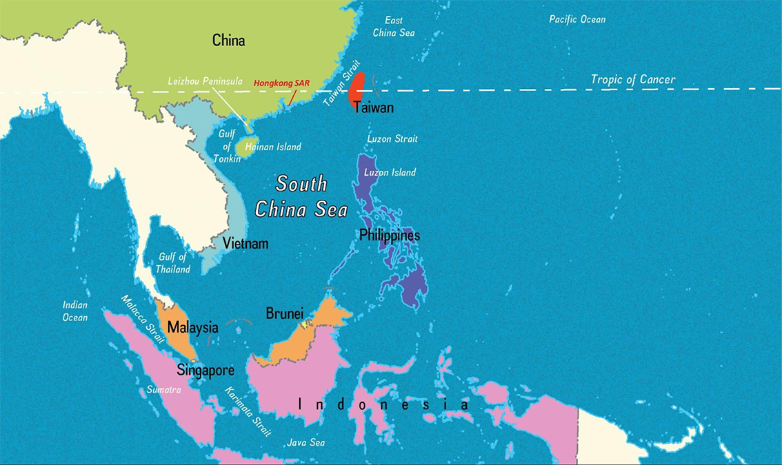
Taiwan Strait
Context
A U.S. warship sailed through the Taiwan Strait in what the American military described as a routine passage, but enraging China, which claims sovereignty over the island and surrounding seas.
About Taiwan Strait
- The Taiwan Strait is a 180-kilometer wide strait separating the island of Taiwan and continental Asia (China to be specific).
- The strait is part of the South China Sea and connects to the East China Sea to the north.
- Former names of the Taiwan Strait include the Formosa Strait or Strait of Formosa.
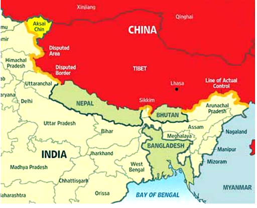
Tsari Chu River
Context
Satellite image shows that China has built a new village in the disputed region of Arunachal Pradesh on the banks of Tsari Chu river. It merges with the Subansiri river at Gelensiniak in the Upper Subansiri district of Arunachal Pradesh.
Key Points
- There are close to two dozen spots along the entire length of the Line of Actual Control (LAC) in all sectors where India and China do not agree on its alignment.
- Line of Actual Control is divided into three sectors:
- The eastern sector which spans Arunachal Pradesh and Sikkim (1346 km).
- The middle sector in Uttarakhand and Himachal Pradesh (545 km).
- The western sector in Ladakh (1597 km).
- The alignment of the LAC in the eastern sector is along the 1914 McMahon Line.
Ukraine
In news
Recently, tension erupted between Russia and England as the latter sailed its warship near the coast of Crimea, a peninsula in Black Sea that was until 2014 formed part of Ukraine.
About Ukraine
- Ukraine is located in eastern Europe. The capital city Kyiv (Kiev) is situated on the Dnieper river in north-central Ukraine.
- Ukraine is bordered by Belarus to the north, Russia to the east, the Sea of Azov and the Black Sea to the south, Moldova and Romania to the southwest, and Hungary, Slovakia, and Poland to the west.
- In the far southeast, Ukraine is separated from Russia by the Kerch Strait, which connects the Sea of Azov to the Black Sea.
- Ukraine has a mostly temperate climate, with the exception of the southern coast of Crimea which has a subtropical climate.
- The shores of the Black Sea and the Sea of Azov are characterized by narrow, sandy spits of land that jut out into the water; one of these, the Arabat Spit, 113 km long.
- Ukraine’s Maidan Revolution ended in late February 2014, when the then President Victor Yanukovych fled to Russia. The Rada (Ukraine’s parliament) appointed an acting president and acting prime minister. They made clear their intention to draw Ukraine close to the European Union.
- In a referendum held later in 2014, the majority of Crimeans voted for integration of Crimea with Russia. Since then, Russia has been exercising its jurisdiction over Crimea, though the European powers and the US contest the legality of the referendum.
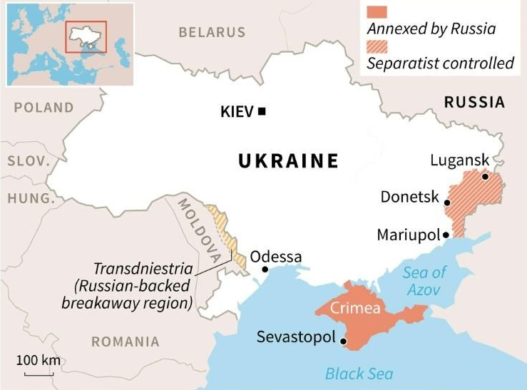
MAP
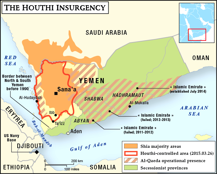
Yemen
Context
The civil war that began in late 2014 in Yemen has entered its seventh year. It is mainly fought between the Abdrabbuh Mansur Hadi-led Yemeni government and the Houthi rebels.
About Yemen
- Yemen is situated at the southwestern corner of the Arabian Peninsula.
- It borders Saudi Arabia to the north and Oman to the northeast and shares maritime borders with Eritrea, Djibouti, and Somalia.
- Yemen's constitutionally stated capital, and largest city, is the city of Sanaa, but the city has been under Houthi rebel control. Thus, its executive administration resides in Riyadh, Saudi Arabia.
- Yemen is a member of the Arab League, the United Nations, the Non-Aligned Movement and the Organisation of Islamic Cooperation.
- A number of Red Sea islands, including the Hanish Islands, Kamaran, and Perim, as well as Socotra in the Arabian Sea, belong to Yemen. The largest of these is Socotra.
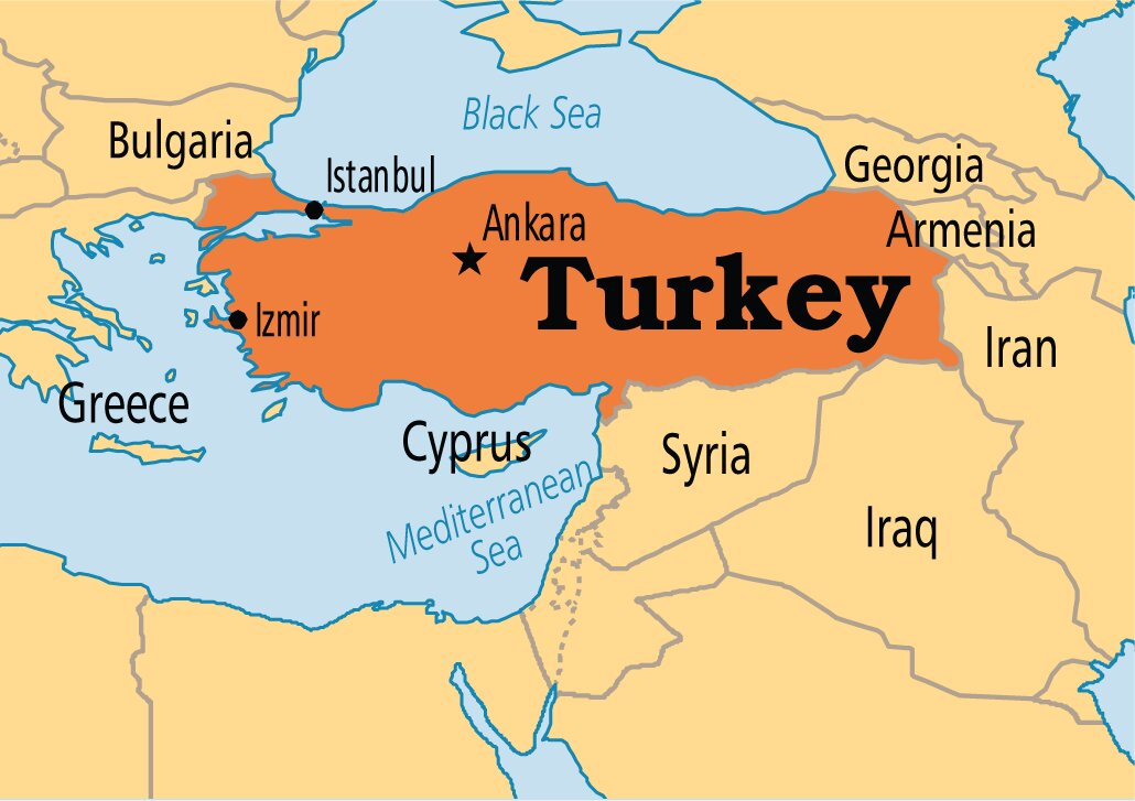
Turkey
Context
Turkish President Recep Tayyip Erdoğan signed a presidential decree turning the Hagia Sophia back into a mosque and opening it as a place of prayer and worship.
About Turkey
- Turkey, with capital Istanbul, is a country straddling Western Asia and Southeast Europe.
- It shares borders with
- Greece and Bulgaria to the northwest;
- Black Sea to the north;
- Georgia to the northeast;
- Armenia, Azerbaijan, and Iran to the east;
- Iraq to the southeast;
- Syria and the Mediterranean Sea to the south; and
- the Aegean Sea to the west.
- Asian Turkey, which includes 97% of the country's territory, is separated from European Turkey by the Bosporus, the Sea of Marmara, and the Dardanelles.
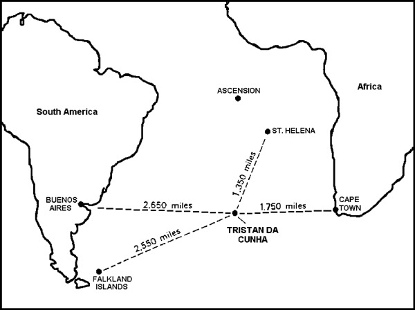
Tristan da Cunha
Context
The isolated UK Overseas Territory of Tristan da Cunha was declared as the largest fully protected marine reserve in the Atlantic Ocean at 687,000 km2.
About Tristan da Cunha
- This archipelago lies approximately 2,432 km off the coast of Cape Town in South Africa.
- It is home to the world’s most remote human settlement. It is the fourth largest completely protected marine area in the world and the largest in the Atlantic.
- Tristan da Cunha is a British Overseas Territory with its own constitution.
- As of October 2018, the main island has 250 permanent inhabitants, who all carry British Overseas Territories citizenship.
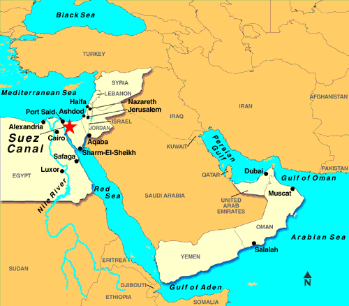
Suez Canal
Context
Traffic resumed in Egypt's Suez Canal after a stranded container ship had blocked it for nearly a week.
About Suez canal
- Suez Canal (built during 1859 & 1869) is a sea-level waterway running north-south across the Isthmus of Suez in Egypt to connect the Mediterranean and the Red seas.
- Topographically, the Isthmus of Suez is not uniform. There are three shallow water-filled depressions: Lake Manzala, Lake Timsah, and the Bitter Lakes.
- The Suez Canal separates the African continent from Asia, and it provides the shortest maritime route between Europe and the lands lying around the Indian and western Pacific oceans.
- The canal extends 193 km between Port Said in the north and Suez in the south. To the west of the canal is the low-lying delta of the Nile River, and to the east is the higher, rugged, and arid Sinai Peninsula.
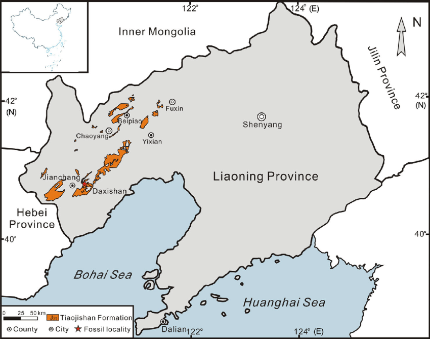
Tiaojishan Formation of Liaoning, China
Context
A new pterosaur fossil was discovered at this location.
About Tiaojishan Formation
- The new pterosaur fossil was discovered in the Tiaojishan Formation of Liaoning, China, and is thought to be 160 million years old.
- It has been named Kunpengopterus antipollicatus, also dubbed “Monkeydactyl”. Geographically, the Tiaojishan Formation is widely distributed in western Liaoning Province and the neighbouring northern Hebei Province (China).
- This formation is lithologically composed of intermediate lava and pyroclastic rocks, interlayered with basic volcanic rocks and sedimentary deposits.
- It contains abundant and well-preserved fossil plants, including leaves, seeds and fruits, permineralized rhizomes and wood.
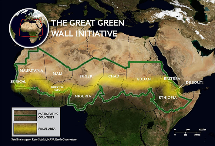
Sahel Region
Context
The Great Green Wall is taking roots in Africa's Sahel region, at the southern edge of the Sahara desert - one of the poorest places on the planet.
About Sahel
- Sahel is a semi-arid region of western and north-central Africa forming a transitional zone between the arid Sahara (desert) to the north and the belt of humid savannas to the south.
- The Sahel stretches from the Atlantic Ocean eastward through northern Senegal, southern Mauritania, the great bend of the Niger River in Mali, Burkina Faso, southern Niger, northeastern Nigeria, south-central Chad, and into Sudan.
- The Sahel has a tropical semi-arid climate (Köppen climate classification BSh).
- Protected areas in the Sahel include the Ferlo Nord Wildlife Reserve in Senegal, Sylvo-Pastoral and Partial Faunal Reserve of the Sahel in Burkina Faso, etc.
NOTE: The Great Green Wall is a symbol of hope in the face of one of the biggest challenges of our time – desertification. Launched in 2007 by the African Union, this game-changing African-led initiative aims to restore Africa’s degraded landscapes and transform millions of lives in one of the world’s poorest regions, the Sahel.
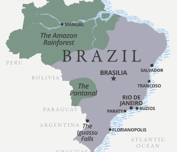
Pantanal
Context
The number of forest fires in the Pantanal has tripled in 2020.
About Pantanal
- Pantanal is the world’s largest tropical wetland, sprawled across Brazil, Bolivia and Paraguay.
- It is a gently-sloped basin that receives runoff from the upland areas (the Planalto highlands) and slowly releases the water through the Paraguay River and tributaries.
- The vegetation of the Pantanal, often referred to as the "Pantanal complex", is a mixture of plant communities typical of a variety of surrounding biome regions. These include:
- moist tropical Amazonian rainforest plants,
- semi-arid woodland plants typical of northeast Brazil,
- Brazilian cerrado savanna plants and
- plants of the Chaco savannas of Bolivia and Paraguay.
- Among the many other benefits that the region offers is its function as a huge area for water purification and for groundwater discharge and recharge and as a source of water.
- In 2000, the Pantanal Conservation Complex - a cluster of four protected areas at the southwest corner of the state of Mato Grosso - was inscribed as a protected UNESCO World Heritage natural site.
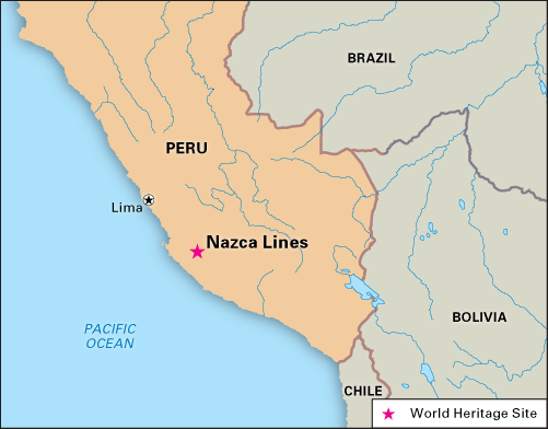
Nazca Lines, Peru
Context
Recently, a giant cat geoglyph was discovered on a hill at the famous Nazca Lines site in Peru.
About Nazca Lines
- Nazca Lines are groups of geoglyphs i.e. the large line drawings that appear, from a distance, to be etched into the Earth’s surface. These are located on the arid Pampa Colorada, northwest of the city of Nazca in southern Peru.
- Most of the Nazca Lines were constructed more than 2,000 years ago by the people of the Nazca culture (200 BCE–600 CE), though some clearly predate the Nazca and are considered to be the work of the earlier Paracas culture.
- While the images dated to the Paracas are often humanlike and bear some resemblance to still-earlier petroglyphs in the region, the subjects of the Nazca-made lines are generally plants and animals - such as a monkey, a killer whale, a spider, and various flowers, trees, and other plants as well as geometric shapes like triangles and spirals.
- They were designated in 1994 as a UNESCO World Heritage Site.
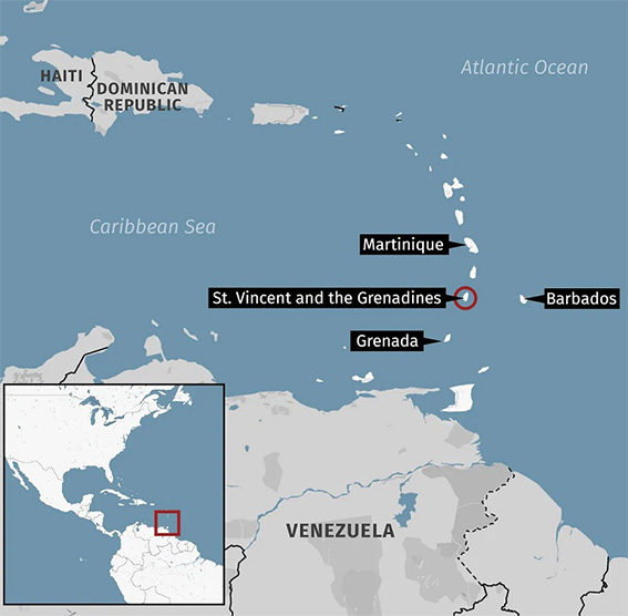
La Soufriere Volcano
Context
The Sulphur Dioxide (SO2) emissions from a volcanic eruption in the Caribbean (La Soufriere Volcano) have reached India, sparking fear of increased pollution levels in the northern parts of the country.
About
- La Soufriere Volcano is an active stratovolcano on the Caribbean island of Saint Vincent in Saint Vincent and the Grenadines.
- Saint Vincent and the Grenadines, located in the southern Caribbean, consists of more than 30 islands and cays, nine of which are inhabited.
- La Soufriere is the highest peak in Saint Vincent and has had five recorded explosive eruptions since 1718, most recently in April 2021.
NOTE: A stratovolcano is a tall, conical volcano composed of one layer of hardened lava, tephra, and volcanic ash. These volcanoes are characterized by a steep profile and periodic, explosive eruptions.
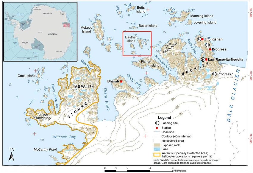
Larsemann Hills
Context
A plant species named Bryum bharatiensis has been discovered by India based scientists in the Larsemann Hills of Antarctica. This is located near Bharati, India’s research station in Antarctica.
About Larsemann Hills
- The Larsemann Hills are a series of low rounded coastal hills along the southeastern shore of Prydz Bay, Antarctica extending for 9 nautical miles (17 km) from Dalk Glacier.
- As an Antarctic oasis, the hills are the home of several Antarctic research stations.
- The abandoned Russian Progress Station.
- The relocated Russian Progress II Station.
- The Chinese Zhongshan station
- The Australian-donated Romanian Law-Racovita Station
- The Indian research station Bharati
- Major geographical features of Antarctica include:
- Vinson Massif (tallest in the region)
- Mount Erebus
- Mount Stephenson
- Vestfold Hills
- McMurdo Dry Valleys
- Bunger Hills
About Bryum bharatiensis
- Plants need nitrogen, along with potassium, phosphorus, sunlight and water to survive. Only 1% of Antarctica is ice-free that could make it difficult for the plant to find a habitable niche.
- The scientists found that Bryum bharatiensis is a moss that mainly grows in areas where penguins breed in large numbers. Penguin poop has nitrogen.
- These plants survive under thick snow during the six winter months with no sunlight and temperatures dropping to as low as -76℃.
- Scientists say it is likely that the moss "dries up to a dormant stage, almost to a seed" at this time, and germinates again during summer in September when they begin getting sunlight again. The dried up moss then absorbs water from the melting snow.
- More than 100 species of moss have been documented from Antartica.
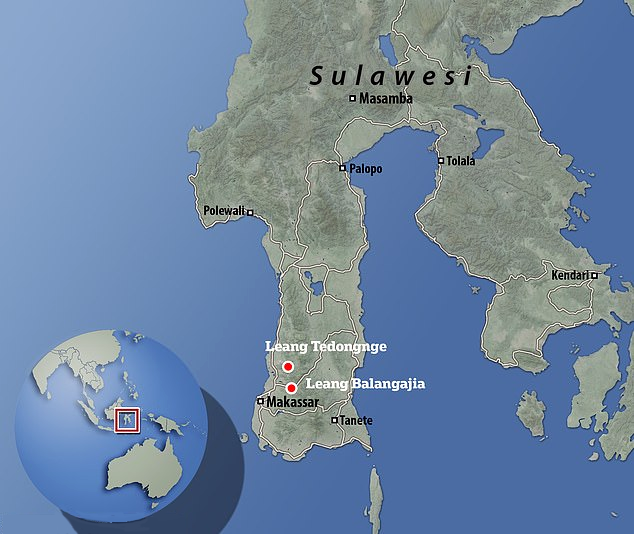
Leang Tedongnge Cave
About Leang Tedongnge Cave
- Archaeologists have discovered the world’s oldest known cave art in Leang Tedongnge cave in Indonesia.
- The cave is in a valley that is enclosed by steep limestone cliffs, and is only accessible by a narrow cave passage in the dry season, as the valley floor is completely flooded in the wet season.
- The cave painting uncovered in South Sulawesi consists of a figurative depiction of a warty pig, a wild boar that is endemic to this Indonesian island.
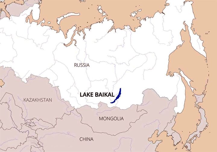
Lake Baikal
Context
Russian scientists recently launched one of the world’s biggest underwater neutrino telescopes called the Baikal-GVD (Gigaton Volume Detector) in the waters of Lake Baikal.
About Lake Baikal
- Lake Baikal is a rift lake located in southern Siberia, Russia. It is the world’s deepest lake.
- It is the oldest existing freshwater lake on Earth (20 million–25 million years old), as well as the deepest continental body of water, having a maximum depth of 5,315 feet (1,620 metres).
- It is also the world’s largest freshwater lake by volume, containing about one-fifth of the freshwater on Earth’s surface.
- Into Lake Baikal flows more than 330 rivers and streams, the largest of which include the Selenga, Barguzin, Upper (Verkhnyaya) Angara, Chikoy, and Uda.
- The only outflow is through the Angara River, a tributary of the Yenisey.
NOTE: Baikal GVD is one of the three largest neutrino detectors in the world along with the IceCube at the South Pole and ANTARES in the Mediterranean Sea.
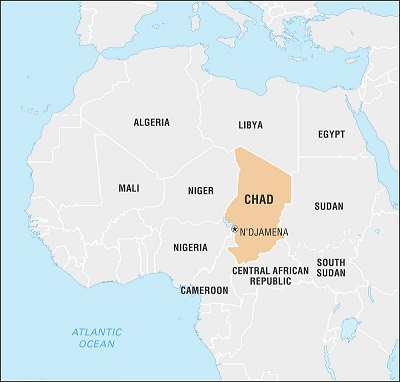
Lake Chad
Context
One of Africa’s largest freshwater bodies, Lake Chad, has shrunk by 90%.
About Lake Chad
- This freshwater lake is located in the Sahelian zone of West-central Africa.
- It is surrounded by four countries - Chad, Cameroon, Niger, and Nigeria.
- It is the largest lake in the Chad Basin. Chad Basin is a vast depression in Central Africa that constitutes the largest inland drainage area on the continent of which Lake Chad forms a part.
- The Chari River, fed by its tributary the Logone, provides over 90% of the lake's water, with a small amount coming from the Yobe River in Nigeria/Niger.
- A 2001 study published in the Journal of Geophysical Research blamed the lake's retreat largely on overgrazing in the area surrounding the lake, causing desertification and a decline in vegetation.
- The United Nations Environment Programme and the Lake Chad Basin Commission concur that at least half of the lake's decrease is attributable to shifting climate patterns.
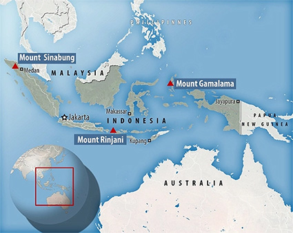
About Semeru volcano
- Recently, Semeru volcano erupted in Indonesia’s East Java province. Semeru - also known as “The Great Mountain” - is the highest volcano in Java and one of the most active.
- Indonesia, with the maximum number of active volcanoes in the world, is prone to seismic upheaval due to its location on the Pacific’s Ring of Fire.
- Semeru volcano is also part of the Island arcs formed by the subduction of the Indo-Australian plate below the Sunda Plate (part of Eurasian Plate). The trench formed here is called Sunda trench whose major section is the Java Trench.
NOTE: The Ring of Fire, also referred to as the Circum-Pacific Belt, is a path along the Pacific Ocean characterized by active volcanoes and frequent earthquakes. Its length is approximately 40,000 kilometers. 75% of Earth's volcanoes - more than 450 volcanoes - are located along the Ring of Fire.