China’s Dams and Their Effect on Brahmaputra in India | 07 Jun 2025
Why in News?
The Brahmaputra River has garnered attention due to concerns over China's hydroelectric projects on the river. With the potential impact of Chinese dams on the river’s flow in India, this issue has raised questions about India’s water security.
How could Chinese Dams Affect the Flow of the Brahmaputra in India?
- Alteration of Water Flow: China has been constructing major hydroelectric projects like the Medog Hydro Project in Medog County (Tibet), near the ‘Great Bend’ where the river makes a U-turn and plunges into a canyon before entering Arunachal Pradesh, potentially affecting Brahmaputra flow and course.
- This intervention could alter water flow into India and Bangladesh, exacerbating potential water scarcity.
- Ecological Disruptions: China's hydroelectric projects in the region have minimal water storage capacity, any major changes in water retention could lead to reduced flow downstream, affecting flood cycles and water availability for irrigation and domestic use.
- Changes in the water flow could also affect the river's ecosystems in India, including vital wildlife habitats.
- The Brahmaputra supports rich biodiversity, including protected areas like Kaziranga National Park, home to the one-horned rhinoceros. Altered water flow might disrupt fish migration patterns and the natural habitat of other species.
Note: The planned Medog project is expected to have a generation capacity three times that of the Three Gorges Dam on the Yangtze, currently the world’s largest hydropower station.
What are the Key Facts About the Brahmaputra River System?
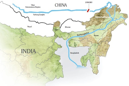
- Origin and Course: The Brahmaputra River originates from the Chemayungdung Glacier in the Kailash range near Mansarovar Lake, where it is known as the Yarlung Tsangpo in Tibet. Upon entering India through Arunachal Pradesh, it is called the Siang or Dihang.
- Drainage: The Brahmaputra basin spans Tibet (China), Bhutan, India, and Bangladesh.
- It enters India west of Sadiya town in Arunachal Pradesh, with its catchment area across Arunachal Pradesh, Assam, West Bengal, Meghalaya, Nagaland, and Sikkim.
- In India Brahmaputra is bounded by the Himalayas (north and west), Patkari hills (east), and Assam hills (south).
- Brahmaputra River is known as the Jamuna River after it is joined by the Teesta River. From there, it flows south and eventually joins the Ganges (which is known as the Padma in Bangladesh) near Goalundo Ghat (Bangladesh), creating a combined stream called the Padma.
- The Padma eventually joins the Meghna River, and flows into the Bay of Bengal.
- The Sunderbans Delta is primarily formed by the combined sediment deposition of the Ganges and Brahmaputra rivers, along with contributions from the Meghna River
- The Brahmaputra is 2,900 km long, with only 916 km flowing through India. (The Ganges is the longest river entirely within India).
- Tributaries:
- Right Bank Tributaries: Lohit, Dibang, Subansiri, Jiabharali, Dhansiri,Manas, Torsa, Sankosh and the Teesta.
- Left Bank Tributaries: Burhidihing, Desang, Dikhow, Dhansiri and the Kopili.
- Geographical and Ecological Significance: Brahmaputra holds over 30% of India’s total water resource potential and it contributes 41% of India’s hydropower potential.
- Unique Features: Majuli, the world’s largest river island, is located in the Brahmaputra in Assam.
- Umananda, the smallest river island in the world, is also in the Brahmaputra in Assam.
- India’s Monitoring Efforts Along Brahmaputra: India covers about 34% of the Brahmaputra basin but contributes over 80% of its water due to heavy rainfall (2,371 mm) and snowmelt, unlike the dry Tibetan Plateau (low rainfall ~300 mm annually).
- Tributaries within India further boost the river’s flow. The basin holds 30% of India’s water resources and 41% of its hydropower potential, with Arunachal Pradesh leading development despite challenges.
- The proposed river-linking projects Manas-Sankosh-Teesta-Ganga Link, joining the Manas, a tributary of the Brahmaputra, to the Ganga via the Sankosh and Teesta; and the Jogighopa-Teesta-Farakka Link, joining the Brahmaputra at the planned Jogighopa Barrage to the Ganga at the Farakka Barrage aim to transfer surplus water to dry areas and are unlikely to be affected by Chinese upstream activities.
- Hydro Electric Projects in Brahmaputra Basin (India):
|
Name |
State |
River |
|
Chuzachen Hydroelectric Project |
Sikkim |
Rangpo & Rongli |
|
Doyang Hydroelectric Project |
Nagaland |
Doyang |
|
Karbi Langpi Hydroelectric Project |
Assam |
Borpani |
|
Kopili Hydroelectric Project |
Assam |
Kopili |
|
Myntdu Leshka Stage-I |
Meghalaya |
Myntdu |
|
Pagladia (Kamrup) |
Assam |
Pagladia |
|
Ranganadi Hydroelectric Project |
Arunachal Pradesh |
Ranganadi |
|
Rangit - III Hydroelectric Project |
Sikkim |
Greater Rangit |
|
Subansiri Lower Hydroelectric Project |
Assam |
Subansiri |
|
Teesta - V Hydroelectric Project |
Sikkim |
Teesta |
|
Teesta Low Dam III Hydroelectric Project |
West Bengal |
Teesta |
|
Teesta Low Dam IV Hydroelectric Project |
West Bengal |
Teesta |
|
Umiam Hydroelectric Project |
Meghalaya |
Umiam |
|
Umiam-Umtru Hydroelectric Project |
Meghalaya |
Umtru |
|
Umtru Hydroelectric Project |
Meghalaya |
Umtru |
UPSC Civil Services Examination Previous Year Question (PYQ)
Prelims
Q. With reference to river Teesta, consider the following statements: (2017)
- The source of river Teesta is the same as that of Brahmaputra but it flows through Sikkim.
- River Rangeet originates in Sikkim and it is a tributary of river Teesta.
- River Teesta flows into Bay of Bengal on the border of India and Bangladesh.
Which of the statements given above is/are correct?
(a) 1 and 3 only
(b) 2 only
(c) 2 and 3 only
(d) 1, 2 and 3
Ans: (b)