Draft Regional Plan 2041: NCR | 14 Oct 2021
Why in News
The National Capital Region Planning Board (NCRPB) has recently approved the 'Draft Regional Plan 2041' according to which the National Capital Region (NCR) is likely to reduce in size.
- NCRPB was set up in 1985, to promote balanced development of the NCR and to avoid haphazard development.
Key Points
- About
- New Boundary
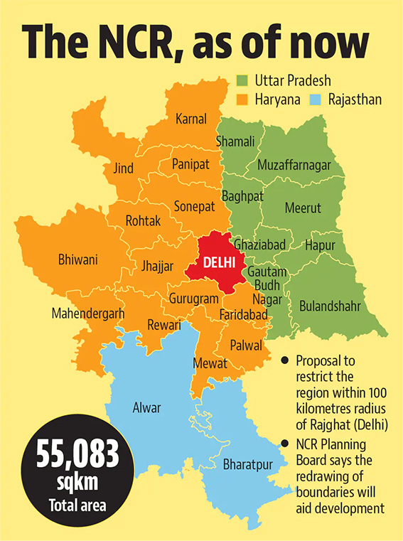
- The geographical size of the region will be a contiguous circular region of 100km radius from Rajghat (Delhi). The area in the 100km radius can be developed as a core area.
- NCR is a region envisaged in 1985 for coordinated urban development in and around Delhi.
- Beyond 100 km radius and up to the existing NCR boundary, all notified cities/towns along with a corridor of one km on either side of connecting expressways/national highways/state highways/Regional Rapid Transit System will be included.
- Currently, the NCR consists of 24 districts in Uttar Pradesh, Haryana and Rajasthan and entire Delhi, spread across an area of 55,083 square kilometres.
- The geographical size of the region will be a contiguous circular region of 100km radius from Rajghat (Delhi). The area in the 100km radius can be developed as a core area.
- Name of Natural Conservation Zones
- The name of natural conservation zones, as introduced in the Regional Plan-2021 will be changed to “natural zones” in the upcoming Regional Plan-2041.
- Empowering States
- States will be empowered to decide whether tehsils that fall partly inside the NCR boundary should remain in it or not.
- Slum-free NCR
- The DRP 2041 Plan will pave the way for a future-ready, slum-free National Capital Region with an air ambulance facility and high-speed connectivity through helitaxis, road, rail, and inland waterways.
- Improved Rail Connectivity
- The Plan proposes to explore the feasibility of a 30-minute Mass Transit Rail System (MTRS) from the nearest NCR boundaries to Delhi.
- New Boundary
- Implications of the Move
- If implemented, parts of Panipat in Haryana and Muzaffarnagar in Uttar Pradesh will be dropped from the new NCR map.
- The idea is to have a compact area so that the development can be planned in a better manner.
- It will benefit the rural areas, as the state governments can plan for their development in a better manner.
- Issues Involved
- The NCR currently spans around 150-175 kilometres, covering entire districts and their rural areas. But with the approval of Regional Plan 2041, areas beyond 100 km are not likely to be the main part of the NCR.
- Lack of access to basic services of water and sanitation and other facilities in the region.
- Other issues included legality of some of the properties, narrow access roads, congestion, conflicts between commercial and residential uses, quality of drinking water and water logging.
- Vulnerability and risks related to disasters such as fire, earthquakes, etc.
- Lack of coordination between multiplicity of agencies like DDA, Delhi Jal Board, Flood and Irrigation Department, and various municipal corporations.
Way Forward
- The challenge of multiplicity of agencies needs to be dealt with by the government. This will increase coordination and cooperation among these agencies.
- There must be a strict adherence to plans for cleaning of water bodies and drains which has been a challenge for agencies in Delhi for years. Dumping of waste in the Yamuna river also needs to be strictly regulated.